April 22 Basingstoke Canal (Odiham to Greywell)

Odiham Castle

Our plan for the day was to walk along the Basingstoke Canal from Odiham to Greywell Tunnel, find a couple more caches in the village of Greywell before returning to Odiham via North Warnborough. We hoped to arrive back in Odiham before the forecasted heavy rain arrived.

The Basingstoke Canal ran from Basingstoke to Weybridge (where it connected to the River Thames). Like many other canals it fell derelict in the 1950s.  Much restoration has taken place, but sadly the full route cannot be reopened as the Greywell Tunnel has collapsed.

We walked this section of the canal in 2011, as it formed part of the ‘Three Castles Path‘; a route linking Windsor Castle, Odiham Castle and Winchester.  It apparently forms the route that King John took prior to signing the Magna Carta.

We should have parked in the car park next to the canal, but our memory suggested it was only for users of the John Pinkerton, a canal boat trip company. We parked in the road, and just we were about to join the towpath we were asked whether we were with a ramblers group. Apparently a group from Staines-Upon-Thames were meeting at the car park at the same time we were starting our walk.

We joined the towpath and looked for the first cache. In fairness we knew we weren’t going to find it, as it needed some sort of boat/canoe/inflatable to reach the far bank. As we couldn’t even see the cache from our side of the canal, we didn’t try to commandeer a boat from a passer-by. There was much going on, the John Pinkerton was about to leave with a 50th birthday party on board, a couple of ‘travellers’ were lighting fires, and were having fun with their horse-and-carts.

We strode away, anxious to keep ahead of the other rambling group. They had caught us by our first genuine cache attempt of the day. Several trees and ivy to search and sadly a did-not-find for us. A bad start.

Our next cache was an adventure lab cache. We had 5 waypoints along the canal and a question to answer at each. The first was a little distance away at a swingbridge, the second at Odiham Castle. The castle is a ‘ruin’ anyway, but clearly there have been some incidents recently with the brickwork as scaffolding surrounded the castle. We had to do some counting in the castle, and it wasn’t easy. Inside were fences protecting the castle walls from people’s hands. We had to count the green upright fence poles all the way round. These poles were 4-6 inches apart and it took us some time…and then we disagreed on an answer. Mrs Hg137 counted again, while Mr Hg1307 set about the investigation work for an earthcache based on the geology found in and around the castle walls. Mrs Hg137 put her number into the adventure lab… another failure. Mr Hg137 counted and he managed to get the correct answer. To give you some idea the final number is in the 250-350 range!

After getting the answer correct, and completed the earthcache questions, we paused for coffee. About this time the John Pinkerton arrived, and some of the attendees of the 50th birthday left the boat to admire the castle.

John Pinkerton

Just beyond the castle is the  ‘head of navigation’ and the boat turned round while some of the partygoers stayed onboard, as the other half went round the castle.

We resumed our walk, and almost immediately had another adventure lab question to answer, this time to do with the River Whitewater which went UNDER the canal. It is very unusual for this happen, and we were not aware of this feature when we walked the Three Castles Path previously.

The path on a Saturday was quite busy, cyclists, dog walkers all out and about before the forecasted afternoon rain arrived. About a mile after the Whitewater we arrived at Greywell Tunnel, which is now a renowned bat roost with several species of bat roosting there. This was our final question for the ad lab, and we successfully answered it. This gave us the coordinates for a final, bonus cache…some distance back along the canal, probably near the castle. Sadly for us.. not part of our planned route.

Greywell Tunnel

We were in the village of Greywell, and we had a couple of caches to find. The first, hidden in the roots of a tree. Sadly for us, and like many cachers before us, we took the wrong footpath to the cache and ended up the wrong side of barbed wire fence.

After some retracing, we found the cache quite easily.

Unlike our next cache.

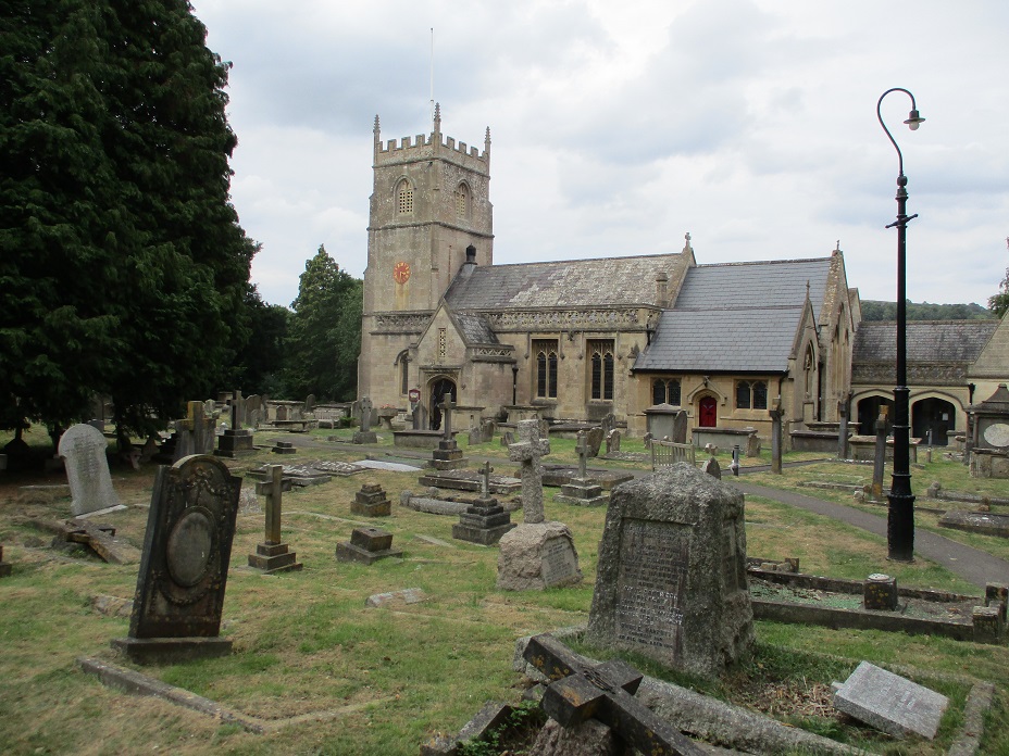
Part of the ‘bat’ series around the Odiham area. Hidden unusually in the porch area of a church.

Gardeners were leaving the churchyard as we approached and the porch area was full of flower-filled jam jars  – presumably removed from various graves. We weren’t interested in the flowers, but a small ‘bat’. We couldn’t find the bat – we searched high (trying not to knock over the jam jars) and low, all to no avail. We decided to give up and collect numbers for the Church micro multi cache. We visited a grave, collected numbers and ascertained the final was some distance away. We ate lunch back at the porch. There really were few places to hide a cache. We decided to give ourselves 5 more minutes as we supped a coffee. Mrs Hg137 finished hers, and just as Mr Hg137 was finishing his…he spotted the cache. Suffice to say the jam jars were the problem and had prevented a full scale search of a particular area.

We went batty looking for this cache!

We signed the log, and then went to collect the Church Micro multi-cache. As were signing the log… the heavens opened and the afternoon rain (which we were expecting about 3pm, arrived at 130! )

Ugh! We still had some way to go and several caches to find!

We decided to return to the canal (via another cache – this time by the beautiful river Whitewater) and walk back the way we came. Not exciting, but we could hurry if the rain got harder and not think about navigation. It also gave us a change to collect the adventure lab bonus cache. Even this was tricky, as a group of people loitered next to its location for far too long, which prevented us from searching.

We returned the car, damp and slightly disillusioned that we had to abandon our route.. but on the bright side we can always come back another day!

March 17 : Frimley Lodge Park, Surrey

Hello, Mrs Hg137 here.

On a warm, sunny Friday afternoon in March, with spring in the air, we were out for some geocaching in and around Frimley Lodge Park.

We weren’t far from the car park when we came upon our first cache. It was easy to see – a bit too easy – part of it was in plain view – and we retrieved it and signed the log while no-one noticed (we hope). Fortunately, most attention was elsewhere as Frimley Lodge Cafe was being reopened after refurbishment, and people were enjoying the official ceremony.  It was also fortunate that we weren’t here on Saturday morning at 9:00, as Frimley parkrun starts from here, and over 400 runners would have been rushing past us – it would have been much harder to be unnoticed then!

We walked across the park to the miniature railway.   No trains were running today (that’s mostly at weekends), but all was neat and tidy, ready for the coming season.   There’s a cache near here, from the Sidetracked series (based on train stations – large, small, or miniature – overground or underground).  We worked out the coordinates for the caches quickly, then set off to find it.  So far so good; but we made a terrible mess of getting there, with the GPS consistently pointing to somewhere we couldn’t reach. After one-and-a-half large circuits of the railway, frustrated and fed up, we reached a place we’d already passed by (once? twice?) and eventually finding what we sought.

Round the park we went again, passing rabbits brazenly grazing on the football fields in broad daylight, then made our way to the towpath of the Basingstoke Canal and along it to an aqueduct where the canal passes over the railway.  We had a good look down at the railway: there are quite a lot of trains!  Of course, we were here to look for a (very new) cache, which we found after more searching than strictly needed.

On our return leg back to the car park, our final cache was to be a 17-year old example placed in 2006 (ancient in geocaching terms!).  We needed to locate some numbers and use them to generate coordinates.   Our efforts were mixed: we found two different answers for one of the numbers, totally failed to find another, and got another one after thought, angst, and a lot of studying of miniature railwayana.   Educated guesses gave us a series of plausible coordinates and we set about visiting each in turn.  One guess took us to the centre of a car park, one nearly took us to the centre of the canal, and the third was correct. We knew we were there when we spotted something that matched information in the cache description. And that was it: a great cache, the promise of spring ahead, and a lovely park, with something for everyone.

Here are some of the caches we found:

September 3 : Kennet and Avon Canal : Avoncliff to Bath

Hello, Mrs Hg137 here.

This was it: the final section of our walk along the Kennet and Avon canal from Reading to Bath.  We had about eight miles of towpath walking, snaking along the Avon valley, to take us from Avoncliff aqueduct to the junction of the canal with the River Avon in central Bath.

We were staying nearby, and our plan was to catch the train from Trowbridge to Avoncliff station, walk to Bath, then catch the train back.  All started well; tickets bought, boots on, and we had time for a short wander to a ‘Sidetracked’ geocache close to Trowbridge station.  (As the name suggests, this series of caches are all located at or close to existing or former stations.)

Avoncliff station - short platfroms!
Avoncliff station – short platforms!

But … plans do go wrong …   Avoncliff station *should* have been easy to reach. But we didn’t realise that the platforms are very short indeed at this station, and we were in the wrong part of the train at the crucial moment. We couldn’t get off!  We had to go to Bath, wait an hour, then catch the return train. Ho hum, we reached Avoncliff, much later and much more stressed than intended.

Leaving the station, we had another ‘Sidetracked’ cache to find.  While standing there, puzzled, a dog-walking muggle couple went by, saying to each other “geocachers, I reckon” as we examined a fence. We admitted guilt.

Hire boat (clear roof)
Residential boat (not so clear roof!)

Off we went along the towpath.  It was wide and well surfaced, and had a fair few moored boats, many of which look to be residential.  (Tip: hire boats have mostly empty roofs, there is little stored on them.  Live-aboard boats typically have all sorts of stuff stored on the roof – bicycles, wood, plants, buckets, wellies, sacks of coal … )

About a mile along the canal we reached Murhill wharf, the remains of a tramway which brought stone from nearby quarries down to the canal for transport.  There was a cache here, and on our return trip we were hailed by two muggle walkers on the towpath (the other side of the canal) who asked us if we had turned back because the path was impassable. We explained the reason for going part way (a cache) and reassured them that the path is fine both sides of the canal at this point – they were planning to incorporate it into a circular walk.

We now had a couple of miles of cache-free walking.   It was all very tranquil and pleasant; the canal clung to the sides of the valley above the River Avon.  For the most part we were walking through trees, though there were occasional views out across the valley.   The canal crossed back across the Avon at the Dundas aqueduct, and stopped to talk to the owner of a working boat which supplies coal and diesel to the boats along this stretch.   Crossing the aqueduct, we (unknowingly) also crossed counties, left Wiltshire, and were now in Somerset.  We were only two miles away from the point where the canal joins the river in central Bath, just over the hill, but over five miles walking along the towpath.

After a while we emerged onto a flatter area of ground, skirted some playing fields, and arrived at Bathampton.  We stopped for a couple of lovely icecreams from the Café on the Barge, then crossed the road to the village church, St. Nicholas.  Several notable people are buried in and around the church, including the first Governor of New South Wales and Walter Sickert, the artist.  We had a quick look but didn’t spot any of their graves: we’d ‘lost’ an hour with all the train hassle earlier on, so couldn’t linger.   We found the Church Micro cache nearby, then returned to the towpath.

St Nicholas Church, Bathampton

There were no nearby geocaches for us to find until we reached central Bath, so we just walked and watched as the city came closer and the terraces of Bath Stone houses lined the valley. We passed Undercliff urban farm, and were then among houses.

Some short tunnels, no longer than wide bridges, took us under Cleveland House, originally the offices of the canal company and past Sydney gardens.  We reached the start of the flight of six locks that drop the canal down to the river.  There used to be seven locks, but two were combined into one, Bath Deep Lock, when work was being done on the A36.  It’s the second deepest lock in the country, 19 feet 5 inches (5.92 metres) drop, and it looked scarily deep to me!  (FYI: the average lock is about 8-9 feet drop.)

Bath Deep Lock
Bath Deep Lock

And then the canal emerges onto the river with little ceremony, through a small opening almost opposite the railway station, a not terribly auspicious spot.  The Kennet and Avon goes on to Bristol, but we’d chosen to end our walk here.   After some obligatory high-fives and photos, we crossed the river and headed for the station, with just time for another ‘Sidetracked’ cache to round off the day. Maybe we’ll return and finish the remaining twenty-five miles to Bristol, but, for this year at least, time had got ahead of us.

It had been a great walk: we started just before Easter, as the days lengthened in spring and the weather warmed.  One of our first sections coincided with the Devizes-Westminster canoe race, the world’s longest non-stop canoe race (125 miles).  As the countryside bloomed into spring and then glorious early summer, we followed the Kennet up to Newbury and Hungerford, and onto the canal section.   By the end of June we’d reached the summit level, just past Crofton, where we’d seen the beam engines working away, pumping water to the top.   Then the weather turned hot … very hot … and our resolve to go walking melted away for a few weeks.    By mid-August we’d reached Devizes and walked down the massive flight of locks at Caen Hill.   The days were shortening now, and though still warm, summer was nearly over, so we needed to get on, and walked the last section, from Caen Hill into Bath over three days in late August/early September.   Seventy-five miles of great walking with lots and lots to see.  

Here are some of the (not very many) caches we found:

August 29 : Kennet and Avon Canal : Hilperton to Avoncliff

Bradford-on-Avon

Unusually for us, we were walking for two consecutive days on the Kennet and Avon Canal.

The car journeys to and from the canal had become quite long, so we decided to stay in a hotel overnight giving us an earlier than normal start for our second day.

We started at Hilperton, and set off on a shortish, and relatively cacheless, section of the canal to Avoncliff. Our first cache, part of the Little Bridge series of caches, was a short diversion away from the canal about a mile or so from Hilperton.

We wandered through a narrow path surrounded by blackberry bushes. We passed a young lad as the path widened, we wondered if he was a cacher, but no – he was just walking from the nearby houses to the canal.

Here’s the little bridge, now where’s the cache ?

A rickety-looking iron bridge stood over a stream, and we had various trees to search – but we didn’t find the cache. We suspect the cache was under a fallen tree, surrounded by brambles and nettles, but after yesterday’s ‘bloody’ adventure we were perhaps a bit too circumspect.

We’ve not had a good run of finding the first cache of the day. This was our third successive trip where we had failed at the first.

Back on the canal, the towpath had also become National Cycleway 4. The cycleway starts in West London and heads Westwards through England and Wales to Fishguard. The canal towpath had shared the route with the cycleway before, but today being a bank holiday Monday, there were more cyclists than we used to. Many of the cycles were without bells, and gave little warning for us stand aside. (In fact, the cyclists should have given way to us…but none of them did)

Cyclists weren’t the only busy people we saw. Many of the boat owners viewed the Bank Holiday as ‘one of the last days of summer’. Many were busy sawing tree branches into logs for winter fuel. Other were clearly making their boats ‘winterproof’.

Bradford-on-Avon Marina

Our first geocaching find of the day, and the only cache near to the canal, was opposite Bradford-on-Avon Marina. A gate/stile led into a field, and while Mrs Hg137 searched the gate (Hint “by gate post under stone”), Mr Hg137 walked further into the undergrowth with the GPS. It led to another gate, this one covered in bushes, and by the side a stone covered the cache! Always trust the GPS !

Just a few yards further on a road crossed the canal. We walked along the road a short way to a cache called ‘beehive’. The cache was named after a local waterside pub called ‘The Beehive’ which closed in 2017. A quick find, once we understood the hint.

We are getting closer to Bath !

Opposite the cache was another road called Moulton Road which ran parallel to the canal for some distance. We would cross or walk by Moulton Road a couple more times as we left the canal in search of caches.

The first time we left the canal was to undertake a multi. We collected the appropriate numbers from various street signs, and then walked through various alleys and cut-throughs arriving at a less-than-inspiring ground zero. A lamppost, with a bit of scruffy vegetation at its base. The sort of location our canine friends like to use. Fortunately, the cache was ok, but this was definitely one of those caches we regretted undertaking.

Our next cache was part of the ‘Supermarket Sweep’ set of caches. Again, placed some distance from the canal (a short walk along Moulton Road before crossing the canal). The Supermarket Sweep series of caches seems to have become less prevalent. Most were placed over 5 years ago – this one was placed in Sainsbury’s Car Park. This should have been an easy find, as it was hidden in the armco perimeter of the car park. We looked for about 10 minutes, until Mrs Hg137 just glimpsed the cache well tucked away.

It was late morning, and the trip to Sainsbury’s reminded us it was approaching lunchtime. We vowed that the next seat would be lunch. That seat, as it turned out, was quite a few minutes walk away, near the Bradford-on-Avon canal lock.

Why is it -there is never a seat when you want one ?

People were thronging around the canal lock, boats were jostling for mooring spots, everyone was enjoying the Bank Holiday sunshine. And as we approached, a seat became free! Amazing !

We sat and ate our lunch. Then we looked at the GPS… we were within 10 feet of another cache. Mrs Hg137 walked behind the seat and found it in the undergrowth. Mr Hg137 did his best to ‘protect’ the seat so we had a space to sign the log. Log signed and cache replaced, we finished our lunch with a quick cup of coffee. As we did so, we were aware of an elderly couple with two dogs. They stood a few yards away, feeding their dogs ‘doggy ice cream’ they had purchased from a nearby shop. Both dogs looked plaintively up every few seconds and were rewarded with the ice cream treat. As we left, the couple and dogs headed for the seat to continue the ice cream eating. We thought it a good idea too, and went to the same ice cream parlour and bought ‘human’ ice cream for ourselves. We discovered the ice cream shop had been opened by Prince Charles!

We walked on, beyond the canal lock, and the towpath was even busier. Here many of the boats were ‘trade boats’ and members of the public were buying items from the ‘floating shops’. The ‘record boat shop’ was very popular.

Just as were leaving Bradford-on-Avon we noticed below us, another waterway, The Avon. (The clue of course is in the town name). For the rest of our route to Bath, would have the Avon at our side.

The Willow Maze

We had no more caches to find, but we did take one more diversion – to a willow maze close to the Avon. Time was pressing and we didn’t want to spend too much time getting lost in a maze, so we advanced a few yards and retired quite quickly. It didn’t look that impressive at ground level, but many of the maps we have seen, has it as quite a large maze.

Avoncliff

About half a mile later the canal took a 90 degree turn at Avoncliff, and the termination of our walk. Our last 2 days had seen us walk about 13 miles from the base of Caen Hill. The weather had been fine on both days, which had brought many people out enjoying the canal.

Caches found :

August 28 :  Kennet and Avon Canal : Caen Hill to Hilperton : blood, dredging and snakes

Hello, Mrs Hg137 here.

Barge Inn, Seend
Barge Inn, Seend

Our walks along the Kennet and Avon have all been interesting, but there have not always been many geocaches to find along or close to our route.   Today promised to be different: just over twenty caches to attempt.

It started poorly: we had another try at the last cache of the previous walk.  Once again we couldn’t find it.   Oh well, never mind.  We passed the last few locks of the Caen Hill flight.  Just there, a disused railway line crosses the canal, leaving the pillars of the old bridge in mid-channel.  A cache marks the spot: ‘Over The Canal – Devizes Branch Railway ‘ so we thought we’d go and find it.   Umm, not to be.   An extract from our cache log describes what went on:

…” We hoped this was to be the first find of many in the day.  But it all went badly, horribly wrong.  First of all, we nearly got flattened by a macho cyclist on the towpath. Then it took us an age to find the path that led to the cache. We started to search among the sharp brambles. Worse followed … I got snagged by an especially fierce bramble. I put my hand down to the damp patch on my walking trousers – and it came away red. There was blood, rather a lot of it, soaking a trouser leg, sock, and both hands. The long thorn had nicked a vein.  The flow was staunched with a hanky and a spare Covid mask (second time we’ve used one for this, they work well), but not before talk of tourniquets, A&E, and abandoning the walk. The trousers, leg, and hanky were washed off under a water tap later and all seems to be well.  But we’d abandoned the cache by this time. It really hadn’t gone well.  “…

... scene of the disaster ...
… scene of the disaster …

We went on, and my trousers gradually went stiff as the blood dried.  I was an object of great interest and sniffs for every passing dog for the rest of the day; I must have smelt like dinner!   (FYI – the trousers are black so the bloodstains didn’t show.  Fortunately.)

There were fewer locks now, as the canal descended gently towards Bath, but plenty of swing bridges to slow down the boaters.   We watched, and marvelled, at some of the methods used to moor boats by the bridges (we don’t think you ram the bank either nose or stern first to moor … do you?). Several bridges had caches hidden nearby, which gave us an excuse to linger, and sometimes help with opening the bridges.  And, at one bridge, we spotted something else, a small slow-worm or snake, swimming along the edge of the canal.  Other wildlife is well catered for too: at Sells Green, part of the canal was permanently leaky, flooding adjacent fields.   The solution was to manage the flooding and turn the boggy area into a lake for wildlife.

We passed the Barge Inn at Seend and reached our first geocache series of the day, ‘Full English Breakfast’.   This series had lots of favourites on the cache logs and we were looking forward to seeing what was there.   We weren’t disappointed, they were great.  The caches all had names relating to breakfast – ‘Sunny side up’ – ‘Fried and seek’ – ‘A little shaken’ – ‘Absolute Banger’ – and each was hidden in a suitable container – a salt pot, fake egg, or plastic sausage.   Mr Hg137 found the sausage very exciting and did some extremely non-PC commenting and posing … ‘would you like to sign my’ … ‘shall I wave my … in the air’ … you get the idea!

Absolute banger!
Absolute banger!

We crossed the busy A350 on an aqueduct to reach Semington village, which is much quieter now that the main road goes elsewhere.  Just before the road bridge, there is the bricked-up entrance to the (currently derelict) Wilts and Berks Canal; like many old canals, this is under restoration, but this one has been unused for a century, there is quite some way to go.

Wilts & Berks canal entrance

Our second cache series of the day was based around dinosaurs, with a Jurassic creature attached to each of the cache containers.  Most were hidden in out of the way places, which gave Mr Hg137 the chance to re-use his ‘I wonder if they SAURUS…’ joke (several times, he has a selection of tried and tested [old] jokes, but many fewer original ones!).  A young couple were doing some bicycle repairs near one of the caches. We explained what we were doing (lest they thought we were going to steal their bikes) and showed them the cache when we had found it – great chuckles all round, they liked the container a lot.

There had been recent canal maintenance with bank clearance and reinforcement, dredging, plus attention to the brickwork around locks. I’d thought that this mostly takes place ‘out of season’ but clearly there is always work to be done, we’d passed a number of other areas being repaired along out past route.

One more cache series – based around animals (photos may well appear in our end-of-year roundup) – brought us to the end of our walk for the day, at Hilperton, on the northern edge of Trowbridge. At the end of the day we got back to our hotel in Trowbridge; this was a walking weekend, we were going out again the next day.   I had a shower and thought I would rinse out my blood-soaked, stiff walking trousers.   A good idea … but the shower did resemble a famous scene from the file Psycho

And here are just a few of the other caches we found:

August 20 : Kennet & Avon Canal : Horton to Caen Hill

The intense heat of the Summer had abated, and we returned to the Kennet and Avon Canal for a 6 mile stretch starting a couple of miles East of Devizes and finishing a couple of miles beyond Devizes.

Devizes Pond

Our start point was a small layby by the canal near Horton. We parked the car, and descended a slight slope down to the canal. As we did so, we passed a man setting up a camera and tripod. He wasn’t taking a picture of the canal, but of a WWII tank-trap by the roadside. He was apparently undertaking a ‘photography project’ of WWII architecture in the area. We wished well him and set off.

Taking photos of WWII structures

Unusually this section of the canal had two canalside geocaches. Or at least should have had two canalside geocaches. The first one, we couldn’t find at all. Its recent logs gave a chequered history of ‘did not finds’, ‘found on the floor’, ‘found without a lid’, more ‘did not finds’. This cache either is hard to spot, or poorly maintained. We suspect the latter, and after 10 minutes gave up our search.

The second cache, much easier to find, was exactly where the hint said it would be. Shortly after this find, we took a diversion into the town on Devizes. There were a couple of caches, relatively close to the canal, worth finding. Or so we thought.

The first was close to, and indeed on, church property. (We are not sure how permission was granted, as we thought this wasn’t allowed). The churchyard is very beautiful, with an avenue of trees leading away and Devizes Pond nearby. But the hiding place for the cache was disappointing. We had to move several wheelie-bins, before locating the cache attached to a drainpipe. A beautiful opportunity wasted by a weak hiding place.

The pond nearby hosted an Earthcache. Over the years the pond has become a focal point for the town. Its recent history is celebrated by town twinning celebrations. Earlier history tells of ‘moonraking’ at the pond. The ‘moonraking’ episode is described on the http://www.geocaching.com thus :

The legend of the moonrakers was that smugglers detected an approaching Exciseman (revenue agent) on a bright moonlit night. In order to waylay suspicion the smugglers dumped the contraband (usually barrels or kegs of French brandy) into a nearby pond. When the Exciseman had gone they began to fish out the barrels with hay rakes. However, the Exciseman came back and asked them what they were doing. They told him it was surely obvious, they were raking out the cheese they could see in the water. The Exciseman laughed at them for being so stupid and rode off. The “moonrakers” left off raking the moon, laughed at the Exciseman’s naivety and continued to recover their kegs.

The Earthcache involved studying various stones marking the Devizes events, and answering various geological questions about the stones. Fortunately not too difficult.

Examine the stones, and answer some questions

We returned to the canal, and here unusually the towpath was elevated above the canal. This section didn’t last long as soon arrived at the Kennet and Avon Canal Museum (sadly shut on Saturdays, due to lack of volunteers). This location is also the start of the Devizes to Westminster Canoe Race held every Easter. It was eerily quiet as we arrived, and it was hard to visualise the hustle and bustle of hundreds of canoeists as they set out on their 125 mile journey.

The first 19 miles of the canoeists Eastward journey is lock-less, so they have plenty of time to get a paddling momentum. However, if they travelled West, their canal journey would soon encounter the Caen Hill locks.

Officially there are 29 Caen Hill locks, causing the canal to rise (or fall) 237 feet over a 2 mile stretch of towpath. The highlight is the ‘staircase of 16’, but before the main flight is reached, there are 6 other, more spaced out, locks.

At one of these locks we deviated away from the canal to find two more caches. The first, part of the National series celebrating ‘tollhouses’ (in fact this was number 1 in the series!) was an easy find, but did involve crossing a fast road to reach GZ. Nearby in a woodland path was another cache. Or should have been. Under a large-rooted stump, well protected from the elements, was a log book. No cache container, no protective bag, just a log book.

A former toll-house, now a hiding place for a geocache!

At another lock, we spent an hour chasing our tails, as we had two caches to find. The first was a multi, and we had to collect information at or near the lock gates. One piece of information was so hard to spot, we could only see when the lock gates were opening to let a boat through. We calculated the final coordinates, making a navigational error heading to the cache, trying to walk through a shop car park rather than a nearby footpath. At GZ, the cache was tucked behind stinging nettles. Mrs Hg137 gingerly approached the cache, hooking it with the geopole suffering only a couple of stings.

We spent far too long looking for numbers at this relatively featureless lock

Our second cache was back over the canal at the same lock gates. We wandered down a cul-de-sac leading to a refuse dump. (Apparently the cache site celebrated the former Devizes railway line, all very laudable, but placing a cache next to a refuse dump is a new one on us!) The dump was closed, which should have meant an easy search, but while we stood, assessing options three vehicles came by, turned round and drove back – so much for a quiet search.

A short way further on, and we arrived at the Caen Hill flight of locks. We were surprised to see a queue of about 4 or 5 boats, tied up. Were they queuing ? Yes, they were, but because of lack of rainfall, the canal was short of water, and the Caen Flight was only open between 10-1 each day. It was mid-afternoon and the boating crews had an 18 hour wait. It unfortunately meant we wouldn’t witness the manual effort of opening and closing 16 locks, as well as the movement of boats going up and down the flight.

Our disappointment was allayed by attempting a multi-cache. We extracted some numbers from a noticeboard at the top of the flight, and set off down the hill heading towards the final hiding place. It was some way from the locks – quite useful as the footpath by the locks was busy with people enjoying the Summer sunshine. We took a few minutes to find the cache – we knew it was an ammo can, and there weren’t many places to hide one. We eventually checked a large bush. Mr Hg137 spotted something, and discovered a brand new yoga mat in the bush. A yard deeper in the bush was the cache!

Many of the locks in the flight had been ‘named’ – presumably by sponsors when the canal was rebuilt in the 1980s/1990s. Eventually we reached the bottom of the ‘flight of 16’ with the aim of finding another cache. This one, like our first cache of the day, eluded us. We weren’t too worried as our next stage along the canal would start at the base of Caen Hill, and we could re-attempt the canal then.

Caen Hill Flight

So a pleasant walk along the canal, marred slightly by the closure of the Caen Hill flight. With the exception of the ammo can and the earthcache, the caches in Devizes did not inspire (sorry) – the caches were container-less, hidden behind dustbins or next to a scrapyard. Hardly inspirational.

July 30 : Trackable : Cruising the Canals

Hello, Mrs Hg137 here.

Cruising the Canals

A brand new trackable!  And accompanied by a brand new Pathtag.  We were the first to pick both out of the cache where the owners placed them earlier in the month.  The  mission of the trackable:

…”To cruise the canals of the United Kingdom.
Please keep me moving, we would love to see photos of its travels.”…

We’ll carry it round with us for a little while, then return it to the Kennet & Avon Canal as we make our way along it.

There’s not much to say about the journeys of the trackable, since it hasn’t done any journeying yet, so what about the owners, Thallams?    I can’t say for certain, but an inspection of the Geocaching website suggests that they may be based around north-east London / south-west Essex, judging by where most of their caches are placed.  And, from photos they have posted, there may be a caching couple.  Again, from the geocache series they have placed, they like/own dogs (and also like Spongebob Squarepants). 

They’ve travelled all over the UK – north, south, east and west, up mountains,  and by the sea.   And they’ve also cached further afield – Europe and the Americas.  They only started caching around August 2020, and have been very active since then, notching up 4,500 caches in two years – we have done less than that and it has taken us nearly ten years!

July 23 : Kennet and Avon Canal : Wootton Rivers to Alton Barnes

Hello, Mrs Hg137 here.

Four weeks had gone by since our last visit to the Kennet and Avon canal.   It had been so hot … we had spent our time on short local caching trips, early or late when it was less hot, or cooling off at home.

Today’s walk was from Wootton Rivers, along the canal towpath to Honeystreet, then about half a mile north to Alton Barnes, a small village which merges into the equally small village of Alton Priors (combined population ~250).   There are very few geocaches along this part of the route, and they are all concentrated around Alton Barnes and Honeystreet. 

Having parked one geocar at Alton Barnes, we decided to attempt the caches there first; quite a few of them were multicaches and, if the final location for any of them was along the canal, we could collect the cache during the walk.

Our first cache was the Church Micro at Alton Priors, a short distance away across fields.   Having done a bit of research beforehand, we knew that we should find the cache on our way.  And so it was; the cache was out in the open in a field, a few feet from where it should have been hidden, and we almost trod on it by mistake.   Then we visited Alton Priors church.   It became a redundant church in 1972 but it is not abandoned.   When we visited, a Bach ensemble were preparing for a concert that evening – ‘Music for Awhile‘. It looked like the audience of 84 were going to have a good time (we counted the seats).   It was also interesting to see how a harpsichord is assembled!

From here, a short walk brought us to the village postbox where we found another cache, before returning to Alton Barnes church, and another Church Micro cache.   This Saxon church is smaller and older than its nearby counterpart but it is the one still in use – the practical reason may be that it’s by a minor road, with space to park, while the other church is surrounded by fields.  We didn’t search for the cache information when we first arrived, as someone was tending a grave in the churchyard, and we didn’t wish to disturb them or be disrespectful.  Returning when the churchyard was empty, we could easily find the information we needed and soon found the cache.

During World War II, there was an RAF Flying School at Alton Barnes.   Not all training flights were perfect and there were several accidents. ‘Two Memorials’, our final cache of the day, commemorates two of those incidents.   From earlier research, we thought the final cache location might be near our walk, but visited both waypoints regardless.  The memorials take a little finding and gave us some minutes of solemn reflection.   

That was all the cache research and finding done for the day, so we travelled to Wootton Rivers to start our walk down the canal.  By now it was lunchtime and we sat on a lock gate to eat our picnic lunch.   The lock gates weren’t as watertight as they could have been!   But that was the last lock we would see that day.  The fifteen mile section of canal between Wootton Rivers and Devizes is known as the “Long Pound” because it has no locks.   We were walking about half of it, stopping at Honeystreet.    (Canal locks are known as pound locks because they impound the stretch of water in between, which is known as a … canal pound.)

Leaky lock gate at Wooton Rivers

After lunch, we set off along the grassy towpath.   There were very few boats moving, but many moored-up boats which are the homes of live-aboard canal boaters.   It was quiet: in the sections where there were no boats it was very quiet indeed.  About half-way we reached Pewsey Wharf, just north of the village, where there is a pub, a slipway, water point, car park; in this short stretch we saw more activity than in the rest of the seven miles.

Ladies Bridge
Ladies Bridge

Beyond Pewsey Wharf, the canal widens into a small lake.   This is Wilcot Wide Water, a natural pond which was incorporated into the canal and enlarged.   When the canal was built, the owners of Wilcot Manor would only allow access to their land if they were given a lake and an ornamental bridge, Ladies Bridge, a little further along the canal.    Today, the section of the lake which isn’t part of the canal route doesn’t look to be very deep.   We saw a heron standing up in the middle of it!    Here, also, the towpath was joined by the White Horse Trail, a long-distance path which meanders between the eight white horses in Wiltshire.  There’s one on the hill above Alton Barnes.  

We were nearing Honystreet, and hoped we were approaching the cache container for ‘Two Memorials’.   We arrived at the likely location.   Our path was blocked by newish barbed wire.   Oh dear.   We found a way that didn’t involve barbed wire, but did involve climbing through hedges and branches. On arrival – oh dear again – the base of a cache container greeted us, empty and lidless, some little way from its likely location. We searched around and found the lid out in a nearby field, and the logbook a few yards from the box; the red logbook cover was a giveaway, we wouldn’t have spotted it otherwise. The cache was dry and so was the logbook (it hasn’t rained much recently) but the logbook has obviously been very wet and some pages were stuck together.  We reassembled everything we could find – box, lid, log – and replaced it in a place that matched the cache description.   (The cache owners have since visited, done some maintenance, and changed the location slightly.)

From the bridge at Honeystreet, it was a short walk north to find the geocar parked near the church where we had started out.   A good day’s walking, but we wish the caches had been spread more evenly!

And here are some of the caches we found:

June 25 : : Kennet and Avon Canal : Great Bedwyn to Wootton Rivers – and Crofton

Hello, Mrs Hg137 here.

After a break of four weeks, we returned to our walk along the Kennet and Avon canal.   Our original plan was to walk to Pewsey, but we’d found that today was a “steaming” day at Crofton, so we decided on a shorter walk to Wootton Rivers, plus a visit to the beam engines.

We set off from Great Bedwyn.   Even though there was a rail strike, and NO trains, there was one man waiting forlornly on the platform for a train.   He said he’d checked the website … we didn’t see a single train all day … he might have had a very long wait.

Just before reaching the towpath, we stopped to find a geocache, called ‘What is a Brail anyway?’   (FYI it seems to be an area of woodland as there are two woods called ‘brails’ nearby.)    That done, we set off along the towpath, stopping to look for another four caches as we went (finding three); each of these caches took us away from the canal and onto paths or tracks leading into the countryside – which was very pretty indeed.  Summer had advanced since we were here last, and the vegetation has grown – a lot.   

After a walk of about a mile and three-quarters along the towpath – further for us with all those diversions – we’d reached Crofton.   Across the canal was Crofton Pumping Station, with a gentle wisp of smoke coming from the chimney, and behind us was Wilton Water, not a lake but a long, thin reservoir, the source of water for the pumping station.   Sadly, the canal-side gate to the pumping station is closed (Covid?), the only way in is to go further on and to walk back along the road.

Once there, we had a jolly good look round, climbed the stairs, questioned the volunteers, watched the boilers being stoked, the engines starting, stopping, pumping, and took loads and loads of photos.   After 90 minutes or so, we emerged, and ate our picnic lunch on the seats overlooking the canal, reservoir, and railway line – no, we didn’t see a single train!

Returning to the canal, we had a cache to find, ‘Crofton Beam Engines (Wilts)’ – we’d questioned the volunteers and had all the information we needed.  We worked out some plausible coordinate, passed items that others had mentioned in their logs, and arrived at a place that just ‘had’ to be the location. But we simply couldn’t find the cache, though we looked all around and widened our search too.   What a shame, we’d really wanted to find that one, it tied in with our walk.

We walked on up the remainder of the Crofton lock flight.   We passed bridge number 100; Mr Hg137 felt this to be a milestone moment, got excited, and took a photo.   At the top lock, we’d reached the summit level of the canal.   Water from the pumping station is released here and is used to supply the canal which descends on both sides.  The water arrives at the canal via an insignificant looking inlet just above the top lock. 

Bridge 100
Bridge 100

We were told that the pumping station can supply enough water to fill a lock in 15 minutes (electric pumps are used when the steam engines aren’t working).   We didn’t see many boats (and no trains at all), but it must be quite a task to keep the water level topped up.    FYI: at the time of writing, there are opening restrictions on the locks on either side of the summit because there isn’t enough water, the locks are only available for use between 08:30 and 16:30 each day.   Mr Hg137 asked how the locks could be closed:  I’ve seen it done in the past simply by fixing the lock gates shut with a padlock and chain.

For the next two and a quarter miles we walked along the lockless (and cacheless) summit level, gradually descending into a deep cutting.    About a quarter of a mile of the canal is underground, inside Bruce Tunnel, the only tunnel on the canal.   It was very quiet indeed – no boats, cars or people (and definitely no trains).    We climbed up a track and walked across the top of the tunnel.   And then we started to meet people, in groups: specifically, groups of 6-8 teenagers carrying maps and enormous rucksacks.   It wasn’t so quiet anymore.  Aha – DofE participants!   

Emerging from the cutting and a mile or so further on, we reached the Wootton Rivers flight of locks, where the waterway starts its descent towards Bath.    At the bottom of the flight of four locks we reached the road where our geocar was parked, close to the former lock-keeper’s cottage.   Those with a (very) long memory may remember it as the main location for the BBC series “The River” back in the 1980s.

Wootton Rivers
Wootton Rivers

We found our final cache of the day here, making seven caches found out of nine attempted.   We’ve been surprised that there aren’t more caches in the area, since it’s lovely countryside, well served by footpaths, interesting locations, hidey-holes a-plenty.   It would be a great place for a geocache series (or two, or three).   If only we lived closer – we could place some caches here ourselves!

PS We wonder how long that lone traveller waited for a non-existent train? There were NO trains!

And here are some of the not-so-many caches we found:

June 6 : Skipton and Gargrave

Hello, Mrs Hg137 here.

Today was our ‘day off’, part way through a walking holiday based near Malham at Newfield Hall.    Geocaching doesn’t mix well with being on a guided walk (it holds everyone up when we disappear into bushes!) so we reserved our geocaching for the day when we didn’t have a walk planned for us.

Off we went to Skipton, about six miles away.   It had been a while since we visited, so we had a look round, wandered up the wide High Street to Skipton Castle, visited the market, and reacquainted ourselves.  We also fancied a boat trip on the canal, so took ourselves off to sit canalside and watch the boats go by while we waited for the first trip of the day at 10:30. And, while doing this, we espied the statue of Fiery Fred Trueman and thought ‘aha, there’s a cache hereabouts’!   So we worked out some coordinates, and tootled off to a place not so far away (22 yards?  Not quite, but not so far off!) where we soon found the cache.  (FYI: Fred Trueman lived in the nearby village of Flasby and is buried at Bolton Priory, also close by.)

Fred Trueman statue
Fred Trueman statue

Narrowboat ‘Leo’ was now ready for the first boat trip of the day and we spent 40 minutes or so getting an entirely different view of Skipton on a beautiful, quiet, smooth trip along the Leeds and Liverpool canal, then a short trip along the Springs Branch which runs behind the castle.  It’s a different, calmer view of the world from the water …

Having seen Skipton, we moved on to Gargrave.  We had both visited the village a couple of days before, but were part way through a day’s walk and didn’t have time to stop and look for caches.   Today was different.   We started off with a cache near the Village Hall, then crossed the River Aire and walked up to St Andrews Church.  A Church Micro cache starts here; we spent a little while hunting for the waypoints. They are all there, somewhere, but the grass has been (deliberately) allowed to grow in places and that made some things hard to spot.  We ate our picnic lunch in the sunshine while assembling the coordinates.

We spent the afternoon wandering around part of the ‘Gargrave South’ geocache series, which heads south-west out of Gargrave along the Pennine Way, then returns along the Leeds and Liverpool canal.    We ascended gently out of the village, finding caches as we went, and crossing over the railway line that leads from Skipton, to Settle, then on to Carlisle.   As we crossed the railway bridge, a lady came walking towards us, wearing walking boots, carrying a large rucksack.  We asked her if she was walking the Pennine Way.   She replied that, no, she was walking from Lands End to John O’Groats (LeJog), doing 18 miles a day, with no rest days, and was about 41 days into an 83 day walk.   Eek!  That is serious walking and put the paltry amount we had been walking daily – 9 to 14 miles – to shame.  Good luck Rachel Douglas from New Zealand, and ‘may the road rise up to meet you’!

LeJog - Rachel Douglas (New Zealand)
LeJog – Rachel Douglas (New Zealand)

After a few miles, and a few caches, we made our way down to the Leeds and Liverpool canal, reaching the towpath by the locks at Bank Newton.   We walked back towards Gargrave, along the most northerly section of the whole canal.   There were a fair few boats, slowly working their way up the locks; there are 91 locks on the 127 miles of the canal, so they get lots of practice!  

Twelve out of thirteen caches from the ‘Gargrave South’ series later, plus six locks, an aqueduct, and several bridges (foot, road, and rail), we were back at our start point.  But first … there was a very new cache hidden close to our geocar.   It would be churlish not to look for it.   The only snag – it was called ‘Across the Beck’ and that was exactly where it was.  Mr Hg137 climbed down and teetered around on stones in the beck while clutching a handy piece of rope, dangling from a tree.  Miraculously, he didn’t get wet … but he didn’t find the cache. Never mind: we’d had a grand day out in and around the edge of the Yorkshire Dales.

And here are a very few of the caches we found: