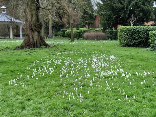
We’d decided on a morning’s geocaching in Basingstoke, a place we’ve rarely visited; and so we found ourselves in War Memorial Park. Even on a chilly weekday morning, the park was busy with joggers, lots of dog walkers and folk out braving the cold air and fresh breeze. The park contains football pitches, a skate park, a play area, an aviary and lots of open space. At 9am on Saturday there is a parkrun and can get very busy (anywhere that hosts a parkrun gets very busy at 9am on Saturdays!). We planned to find a mixture of physical caches, some in the park, some nearby, and an AdLab cache, too, which would mostly take us around the park. (FYI: AdLabs require you to visit several locations and answer a question at each.)
Our initial action was to collect the first stage of a multicache – this gave us coordinates for the second, and final stage, which we’d complete later as our last cache of the morning; some cachers think this stage is actually the final, and sign the coordinate sheet – we didn’t check how many then move on to the other location!
Now, on to the Adlab. We reached one of 6 stone plaques set into the path: this one contains a quote from Ode to Evening by William Collins. A bit further on, we came to an aviary containing cockatiels and budgies, all chirping away merrily. They all seemed warm and happy, but the cold was seeping in and our fingers and toes were a bit numb.
All Saints Church, Basingstoke
We emerged into the streets by the park and made our way to our next geocache, a Church Micro cache at Basingstoke All Saints, an imposing building about a hundred years old; the original tin church was moved around the corner and is now the church hall. Having worked out the coordinates to the cache, we scooted off to find it, then huddled in the church porch, out of the howling north wind, for a warming cup of coffee.
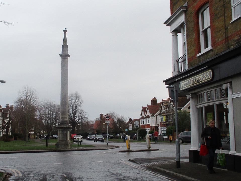
Marginally warmer, we moved on to the Top of the Town, the old town centre, before Basingstoke expanded in the 1960s. The pedestrianised street widened into the Market Place, close to the museum and complete with an almost life-size statue of Jane Austen; or maybe she was very small? Further on, we left the car-free area and reached the northern entrance to the park. Here stands the War Memorial that gives its name to the park.
Once there, we looked for – and failed to find – a couple of caches in the shrubbery; we felt we’d failed at the time, but neither has been found since, and one has been archived; so it wasn’t just us, they simply weren’t there! And finally, we completed that cache we had started right back at the beginning of the morning. The GPS led us on a merry spiral, and we gradually moved inwards – we were pleased when the centre of our spiral was where the cache was located, nice and dry. And that completed our caching; we’d intended to stay longer, and find more caches, but we’d got really, really cold, and drove home to warm up.
And what did we think of Basingstoke – the bit of it we’d walked through? The park was great, and clearly appreciated by the many people using it, even on a cold, grey day. And, having always thought of Basingstoke as a ‘new’ town, the Top of the Town, and the area around, showed us a side of the town we’d not realised was there. An interesting morning – but COLD!
At last, a few days without rain! Off we went to Weybridge, on the south-western edge of London, for some geocaching with firm, dry paths underfoot. After finding some free street parking, we made our way towards the town centre, and the parish church, St James: we needed to count some objects in the churchyard and then to use them to derive coordinates giving us the location of the Church Micro cache nearby.
While in the churchyard, gazing at an impressive tomb, musing, we were approached by a passer-by, who stopped to give an enlightening talk about the town and its history, which gave us information we would use for the rest of the day. The tomb is that of Princess Frederica Charlotte of Prussia – Duchess of York. A monument was erected to her – we’d visit that later, there’s another cache close by there.
Monument Green & original column top
Anyway, we worked out some coordinates for the Church Micro cache, a little way away, and decided to return to them later. We walked out of the busy town centre and through quiet residential streets, collecting some caches as we went. Looping back towards the town, we reached Monument Green. The monument commemorates the Duchess of York, whose grave we’d seen earlier. It was originally topped by a sundial which came from Seven Dials, in central London. This proved a bit top heavy, so it was removed and is now on display by the library; we saw it later, and it was waaay too heavy for that slender column. The adjacent cache was a milestone cache for us – 4500 finds !!! – and it’s a good location, an interesting place we wouldn’t have visited otherwise.
Fancy entrance to Portmore Park
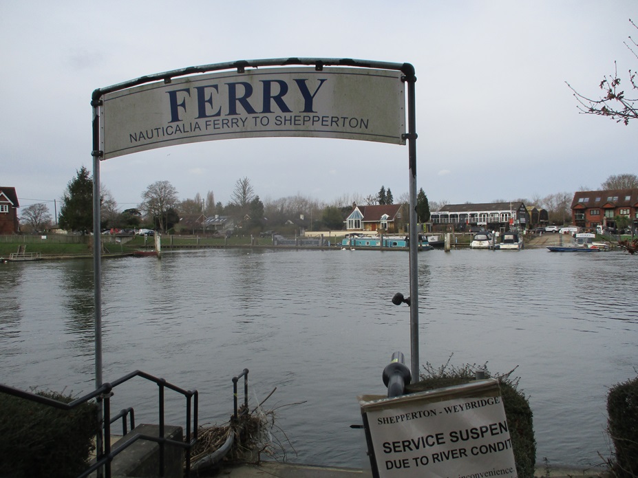
From the green, we headed north, passing some impressive pillars which used to lead to Portmore Park (it’s now a housing estate). We soon reached the river, at the confluence of the rivers Wey and Thames. Both rivers were high, just within their banks, and flowing fast. Just downstream was the Shepperton Ferry. This place brings back memories – back from 2015 when we walked the Thames Path (it’s the only ferry crossing on the whole, nearly 200-mile path). Actually, our main memory was of hanging around on the far side of the Thames for about 25 minutes, waiting while the ferryman finished his lunch (or whatever he was doing!). As the river was much, much higher and faster today, the ferry wasn’t running, but still a great spot and much reminiscing.
Passing D’Oyly Carte Island, we turned away from the river and followed wooded paths and fields back into the town. Once there, we realised we’d missed out one of the caches on our list (doh!), so back we went, to look for ‘Orinoco’s Favourite space’. We were expecting something to do with litter and Wombles, but, no, it was much-loved by the cache owner’s dog. While searching, we were hailed by a dog-walking muggle (non-cacher), wanting to know if we were doing ‘a survey’. Sort of, we said, and Mr Hg137 explained geocaching to him while Mrs Hg137 found the cache container.
D’Oyly Carte Island
Also, once here, we realised we were very close to the location of Oatlands Palace, now a housing estate, once home to Princess Frederica. We asked directions from a passing local and soon found ourselves at the surviving walls and archways of the palace. Very interesting, we wouldn’t have come here but for the local historian we’d met in the churchyard earlier.
Back to the church, to find the Church Micro we’d calculated the coordinates for at the very start of the day. Those coordinates (oh dear): we made not one, but two, howling errors, while working out the numbers, and spent some while searching an entirely wrong place, not once, but twice. We eventually started again, read the description properly and came up with some correct numbers which finally, finally led us to the cache. (One of us has a degree in ‘hard sums’: we should have done better!)
Close to the church is a park and allotments (unusual to have such a big open space so close to a town centre). while walking across the park towards a geocache, Mr Hg137 suddenly slowed, saying … ‘watch that man’ … he was just ahead of us, heading for a spot oh-so-close to where we were going, too. He bent down and picked something up; we walked up to him. Aha! a cacher caught red-handed! Good to meet you, Flyingfox76 ! Also good to meet you, mummycherub, who appeared very soon to ask to be added to the log. We swapped tales of caching, then went on our separate caching ways.
mummycherub and Flyingfox76
Our caching was nearly done now: we followed peaceful suburban streets to the south of the town centre, finding our last few caches, and returning to the geocar. We enjoyed Weybridge: it had far more to see than we were expecting, lots of history, attractive corners, rivers, parks, and glimpses of the past. A good place for a winter walk!
West Horsley is a village partway between Guildford and Leatherhead. It has about 1000 houses, a church and a school but its most famous building is West Horsley Place.
Around the roads and paths of West Horsley and West Horsley Place are various caches. These were our targets for today’s walk.
Our research, didn’t show too many parking spaces in the village, so we parked a little outside just off the main road. Our first cache involved crossing the road to a drinking fountain. This was part of the National series of Drinking Fountain caches.
There were lots of hiding places, but it was only after reading many of the logs did we realise the cache was hidden some way behind a large bramble bush. We couldn’t see it at all, and it was only after Mr Hg137 climbed over a fence (tsk, tsk) that we located the cache, signed the log, and replaced the cache in a slightly more favourable position for the next cacher.
We had one other village outlier cache and we headed there. This again took longer than expected as the ‘magnetic’ cache was no longer a magnet and was hidden deep in grass vegetation. The hiding place was adjacent to a field of sheep, and throughout our searching we were aware of being stared at!
Onto the village, and its retail hub : two shops, a letter box and a phone box being used as a library. The village shop, a charcuterie, was bulging with all sorts of Christmas fare. A constant stream of people were arriving at the shop. The letter box and the phone box were our targets, as the numbers on them were used to derive the final coordinates for a cache in the ‘Fine Pair’ series. We were disappointed to see we couldn’t access the book portion of the phone box, as we needed a key and a book to swap!
The Fine Pair cache was a little walk away, hidden on a road junction sign. Our easiest find of the morning. We then picked up a footpath which skirted the North of the village, until we arrived at a cache called ‘Perfect Vision’. We weren’t quite sure what to find here, and a combination lock cache wasn’t high on our list. This was a standard cache, so we hadn’t had to solve a puzzle, or work out coordinates from elsewhere. We just had a lock to open…but we didn’t know the code. Or did we ? The cache title gave us a very strong clue.
As we walked further away from the village, the dirt track gave way to a muddy footpath. West Horsley is situated between the North and South Downs, in an area known as the Wield. This gets very muddy after heavy rain, and today was no exception.
Close to where 4 footpaths met, was another cache – an easy find in a tree bole. We just finishing putting the cache away when a lady dog walker appeared. We chatted, and her 14-year old dog decided it was rest time. Despite the lady’s best efforts, the dog remained still. We chatted some more, and she pointed out that the footpath we required was temporarily closed because there were sheep in the field. We decided to adjust our cache route, and set off. This was great encouragement for her dog, and the dog and owner slowly followed.
The path led us close to the outer boundaries of West Horsley Place – a mediaeval house rebuilt at various times during the 16th and 18th centuries. The house is striking, and since 2014 has become more well known. The Duchess of Roxburghe owned the house until her death in 2014. With no offspring, the building was passed to her half-sister’s grandson, University Challenge’s Bamber Gascoigne. He had no idea about the house or why he was the sole beneficiary of the house, given that other grandchildren existed. He developed plans to develop into an arts centre, and work is well underway building an opera house at the rear of the building.
The building though has become much famous as a TV and film location. It has appeared in The Crown, Enola Holmes, and My Cousin Rachel. But it was as Button House in BBC’s Ghosts, where fiction and life have become entwined. In the first episode of Ghosts one of the characters, Alison, inherits the house from an unknown relative (like Bamber Gascoigne). Unlike Bamber Gascoigne, Alison suffers a near death experience and is able to see the ghosts of previous people that died there. The series ran from 2019 until 2023.
There are caches on the paths which surround West Horsley Place and we attempted “West Horsley Place” first. Although the cache had been found a few days before our visit, we couldn’t find it. This was disappointing as it was placed with the best view of the house. We concluded that, like the TV series Ghosts, only people with special powers can see the cache.
Rather than locate the remaining three perimeter caches, we took a small diversion to the nearby church (St Mary’s, West Horsley). Here there was an easily found church micro cache (and annoyingly some plentiful parking). Churches, and their churchyards have seats, and we paused for lunch before returning the West Horsley Place.
A one-way system directs cars into West Horsley Place’s car park – and we noted free to access. There were lots of people going in. We discovered that the Place runs Ghosts tours, as well as standard historical tours. Today though was ‘Meet Father Christmas Day’ and young children were appearing at regular intervals armed with balloons and small gifts.
The three caches around the perimeter were easy to find. All reasonable sizes, and we were able place two trackables in the caches, and retrieve another, Gin Tonic Rabbit. We saw the building works of the Opera House. Indeed one cache as placed nearby and the cache owner requested a picture be taken of the cache and opera house to show the ongoing progress. We did this, but in trying to find the best spot for the photo we forgot to undertake one very important task….
The last cache we found was on a different side from the main buildings, hidden in a small root hole. We then arrived back at the “West Horsley Place” cache and had a second look for the cache. This particular footpath was relatively busy and quite exposed, and after a while searching became quite difficult so we recorded it as a Did Not Find.
We headed back to the car, mainly on pavements avoiding the worst of Wielden Mud. We arrived at the car, took our walking boots off, and as we put our walking notes in the car… we saw the log book from the ‘Opera House’ cache! We took the photo as requested by the cache owner, but failed to replace the log book! We had no other option but to drive to West Horsley Place, park up, boot up and walk back to the cache.
A slightly frustrating end to a great day’s caching.
After a cold, wet start to the month, Friday dawned bright and sunny. We headed off to Aldershot for a morning’s caching on dry (we hoped) pavements.
We found a parking space in a quiet suburban road, and strolled along to our first cache, hidden close to St. Mary’s, the first of four Church Micro caches we would attempt today (Church Micro, or CM geocaches are hidden near churches / chapels / cathedrals, active or redundant. There are just over 15000 in the series, making it the largest geocache series in the world.)
From there, we made our way down the hill towards Aldershot Town FC, catching a brief glimpse of the hallowed turf as we went. In front of the entrance we assembled coordinates to find the cache associated with the club. (Editor’s question: why is turf hallowed, especially football turf?)
Aldershot Town FC
Next it was time for a walk in the park and another cache, in Manor Park. What a popular and busy place on a sparkling morning! Dog walkers, runners, mothers and small children, and folk simply taking the air. After a coffee break, watching the ducks and seagulls going about their lives in the pond, we moved on to visit a curry house – not literally, as Mr Hg137 isn’t a curry fan (but I am!) – but instead, to work out the coordinates for yet another cache. This one is part of the Curry Micro series, which started in Brighton and is now spreading across the South of England and beyond.
Incy Wincy Spider, hiding in a hole
We moved on to the most inventive cache of the day, named Incy Wincy Spider. Part way there, we read the cache description and realised we hadn’t got the correct equipment, for this one required us to pour water into a container to make the cache float to the top, and we had no water with us … oops. Fortuitously, we passed an abandoned, half-drunk bottle of water, and took it with us. It turned out not to be enough water … oops again. Plan B – a thin stick – was deployed, and the cache extracted. It was a fun few minutes of problem-solving; luckily we were tucked away along a quiet path between hedges and no-one was watching our efforts.
We circled suburban southern Aldershot, completing the morning’s walk with three more Church Micro caches. Two of the churches supplied us with the coordinates for geocaches, but the third didn’t (it hadn’t been found for a while and is now awaiting attention from the owner). And by now, it was nearly lunchtime and we’d made our way back to the geocar in the sunshine, having visited many a place to pass the time – football grounds, parks, restaurants, and a goodly selection of places of worship – something to satisfy both body and soul!
Kingsclere : as described by a local resident and fellow geocacher, TadleyTrailblazers:
Kingsclere has a Post Office, three pubs, two local stores, a library, hairdresser, butchers, and art gallery, everything a small community could want in this north Hampshire village. A bustling parish with strong community ties and a unique, friendly atmosphere, Kingsclere is a fantastic place to sample the surrounding views and neighbouring villages. This area inspired the novelist Richard Adams to create the world-famous story of Watership Down. ‘Clere’ is thought to have derived from the Saxon and may possibly mean ‘bright’ or ‘clearing’; there is evidence to suggest that Kingsclere belonged to King Alfred between the years of 872 to 888 with the full name being referenced in a chart.
We began our visit to the village with an AdLab cache, which gave us a guided tour of the highlights of the older part of the village. We inspected the Old House (once an impressive solicitor’s office), then, closer to the village centre, two locations linked with brewing, the Malt House, and Popes Mill, and two more associated with drinking, the Golden Falcon and the Crown Inn (all, except the last, are now private houses).
A few doors from the pub was a Methodist chapel, and opposite was the village church, St Mary’s. Crossing the road, we passed toilets, a coffee shop, a convenience store and the local butchers, then went into the churchyard, musing to ourselves that almost all of our spiritual and physical needs were provided for in this small area! Our thoughts were interrupted as it began to rain, hard and cold – this hadn’t been in the weather forecast! We took refuge in the church, had a warming cup of coffee, then headed outside again, where it was no longer raining, but noticeably colder.
A short walk took us past yet another, now unused church, so now we had coordinates for three Church Micro caches to find later on. Next we followed a track uphill to the Recreation Ground, which has a hilltop view over the village, and towards Watership Down in the other direction. After finding two geocaches around the edges of the field, we descended a steep flight of steps to Hollowshot Lane, a straight track running roughly east-west. We had quickly gone from village to countryside, and the sunshine was returning.
Here we had a dilemma: a geoache lay some hundreds of yards away to the east, off our route, so an out-and-back diversion would be needed. AND – said cache hadn’t been found for 5 months, so we could have a long detour for something that was no longer there. After consideration, we decided to try to find it anyway. Once there, we spent some while peering around fruitlessly, then leant on a nearby gate to read previous logs … looking down … we spotted something lying out in the open. Aha! Found it at last. That made the return trip much happier.
Park House Stables gallops
Reaching the road at the end of the track, we made our way back towards the village. We had more detours and diversions to make, this time to look for the cache containers associated with those churches we had passed earlier. In no particular order – one was along a woodland path, one tucked into a concrete post, and the third was in a delightful spot along a stream running through the village.
Park House Stables and their immaculate gallops lay to our left – no racehorses visible today: wrong time of year, wrong time of day.
Our walk concluded along the same clear chalk stream. The rain was gone now, and we finished the day in clear, cold sunshine.
PS And the butchers , which we passed earlier … we went back, went in and bought some lovely venison sausages. Not cheap, but delicious!
Watlington is an ancient Oxfordshire market town; the Ridgeway long-distance path – which we’re walking – passes about a mile to the east of the town. The name suggests a Saxon origin (‘town of the people of Waecal’). The original medieval village was a little west of the present High Street, closer to where the parish church of St. Lawrence stands today. During the Civil War (1642-49), Watlington was occupied by Royalist troops although the king later moved the garrison to nearby Oxford, possibly sparing the town from siege damage.
So why were we in Watlington?
We’d both driven through many times, and sat in a traffic jam in the narrow old streets in the middle many times, but had never stopped. It looked to be an interesting place (though not good for cars).
A more nerdy reason was geocaching – we’d found a ‘challenge’ geocache on our last sortie along the Ridgeway and we thought we could qualify for the challenge by finding some Church Micro caches in Watlington.
The challenge: find 21 Church Micro caches, at least 7 denominations, across 7 counties. In each county, you must find 3 caches of different church denominations. … And we were one county short …
We decided to start by finding three Church Micro caches to complete our challenge. The first, quick and easy, was near the modern Catholic church tucked away in a side street. Next, we set off towards the Methodist church, walking along one of the town’s main streets, and pausing now and then to admire the old buildings and to find information for a later Adlab cache. An elderly muggle (non-geocacher) asked if we were lost … we said we were fine. At the Methodist church, we sat down on a handy bench to work out the cache coordinates. A church official congratulated us on being the first to use his new seat, installed only a week ago … then asked us if we wanted to attend the free Friday lunch … we said we were fine, we had a picnic with us. Time to escape! We crossed the road. Another elderly muggle asked us if we were looking for the free Friday lunch … we said we were fine, he said he was late. And finally, as we searched the several likely places for the cache, a steady stream of folk passed us, all heading for the same place. Right place … maybe the wrong time!
CatholicMethodistChurch of England
Having attracted way too much attention there, we made our way away from the town centre towards the parish church of St Leonards. Once away from the centre, it was much quieter, though the narrow old streets of the town centre are really not suited to large motor vehicles! Many of the places we passed looked oddly familiar: the town is a recurring backdrop to the TV series Midsomer Murders and,coincidentally, our caching route almost exactly followed the walking tour of the town which passes many of the locations.
After two attempts (the first involved a ford), we arrived at the church – another TV location – and stopped for our picnic. After that, we returned our start point via the Adlab cache, and I asked Mr Hg137 what he has thought of Watlington? ‘Less bland than I was expecting!’ came the reply … we’d been (serially) asked if we were lost, each and every time we stopped, invited to a free church lunch, watched a delivery lorry almost get stuck in the narrow side streets, and nearly had to ford a stream. We decided to try for a final cache, in the car park almost next to the geocar. It went wrong. Part of the car park is currently dug up so there’s a big pile of gravel over what may well be the information needed to find the coordinates. We did some hopeful sums and came up with a location not too far away. But on arrival, it was fairly clear that we weren’t in the right place. Oh well, a tiny anticlimax to end a quirky day out.
It had been over a month since our last walk along the Ridgeway.
Streatley marks the half-way point of the Ridgeway, and a complete change of scenery. Gone are expansive views from chalk hills, instead a more urban, riverside walk.
Geocaching walks should really score highly on at least one of the following criteria :
beautiful or historic scenery
large quantity of caches
quality of cache containers or hiding places
Sadly this walk didn’t really score high on any of these indices.
We should have realised our day wouldn’t score highly as we parked our ‘destination’ car in North Stoke. There was a fine pair multi to solve. ‘A fine pair’ relates to a red telephone box and red post box in close proximity. Numbers are extracted from each structure and a set of final coordinates calculated. We decided to do this before driving the ‘start’ car to Streatley. That way if the final hiding place was on our route into North Stoke we wouldn’t have to walk back to it. Sadly for us, the numbers we had to find from the post box didn’t make sense. We had to subtract one number from another… but this gave us a negative number. Hmm. Something wrong. And a strong portent for our caching trip.
As we arrived in Streatley, we drove into the same cul-de-sac we used some weeks previously. We noticed two ladies with two cars doing some odd manoeuvring . Actually it wasn’t odd, they were replicating our actions of some weeks earlier. Parking one car, and driving another to the start. We wished them well on their walk from Wantage to Streatley.
We set off, heading through Streatley’s town centre, and headed East, crossing the River Thames into Oxfordshire. The bridge hosts two long distance paths, the Thames Path (cross the bridge and turn South), and the Ridgeway (cross the bridge and turn North).
Before we turned North, we checked out two more multicaches. One based on the village hall, the other based on the village sign. We sat on a seat on the village green and calculated the final coordinates for both caches. We were in luck, they were both sort-of-ish on our route. We paused for coffee (calculating, quite correctly we wouldn’t see a bench or seat for some time).
Invigorated, we headed North away from Streatley. One of the multi-caches, was close to an estate of houses. Of course we followed the GPS religiously as it pointed left, right, in alleyways, behind garages. It was only when we were at GZ, signing the cache, did we see a less complex route back to the Ridgeway.
Not the most scenic part of the Ridgeway
For about half a mile (seemed longer), we were hemmed in by buildings and trees on the left, and building and gardens on the right. A narrow pathway between. At end of the pathway was the hiding place for the second multi.
The pathway opened out after the cache, to a slightly wider track, with less houses and more trees. We were running parallel to the river, but the trees and occasional house obscured our view. Our next cache was named ‘Cleeve Lock View’, but we couldn’t really see the lock at all! We couldn’t see the cache either. Apparently hidden in a stump or bush, but we couldn’t find it having searched many likely hosts.
Somewhere down there is a lock!
There was only one host to check at the next cache ‘Triangle’. There was only one triangle, a road sign…but no sign of the cache in the sign or at its foot.
We continued on, dispiritedly with consecutive DNFs. We arrived at the large village of South Stoke. Here there was plenty to find. Firstly a 5 stage ad lab. We had to visit several waypoints in the village, and using wireless connectivity answer a simple question. At the first waypoints we were examining a noticeboard with different local numbered walks centered around the village. We entered the answer into the phone… nothing. No response at all. We moved to another waypoint, this time at the local pub. The phone beeped the waypoint question as us… we keyed in the answer… nothing. We had internet connectivity to see the question, but not to enter the answer. Hmm.
Never mind, there is also a Church Micro in South Stoke. It required finding a particular grave to ascertain some numbers. The cache owner had not supplied a waypoint for the grave, so we bumbled our way around the graveyard for some time before alighting on the required information.
It was lunchtime, so we sat and ate, and calculated the final for the church micro. A little distance away, but broadly on our route. But what to do with the ad lab ? We knew the correct answers, but couldn’t get the software to accept them. Now both of us have IT training, and we decided to apply the golden rule. ‘Turn it off, and turn it back on again‘.
We turned the phone off, waited a few minutes and turned it back on. We revisited one the waypoints, and miraculously the number was accepted. We hastily looked for the other ad lab questions – one based in a very well laid out play park, with a Jubilee beacon, fire pit and community orchard. As we answered each ad lab question, we were unusually presented with another. These answer to these questions combined together to give us the final location for a bonus cache. After zigzagging our way around the village we answered all the waypoint questions, assembled the coordinates, and surprisingly found the cache quite quickly.
The church micro was was a little distance from the Ridgeway, and we were grateful for an easy find.
Leaving South Stoke, the Ridgeway dropped down to the River, and for a mile or so, we were in the open countryside which had been missing from our earlier miles. The Reading-Oxford railway line follows the river, and at Cholsey (or more accurately Moulsford), a large brick bridge takes the railway over the river.
We had seen a distant view of the bridge from the other bank when we walked the Thames Path, but this time we were much closer. This bridge is one of two brick bridges build by Isambard Kingdom Brunel over the Thames (the other being at Maidenhead). We hadn’t appreciated that this bridge not only has curved ‘arches’ but the legs of the arch also curve.
There were no caches on this section so we had little to find, until we reached North Stoke. We had done the groundwork on one multi (sort of), but we needed to collect numbers for another Church Micro. Some to and froing around the churchyard, and we discovered the final was some yards back along the Ridgeway.
Or at least should have been. The area had been cleared of vegetation, and new fence panels erected. There really was nowhere for a cache to be hidden. Oh dear.
The cache should have been hidden here… but with all this work…its gone!
All we had to do was attempt the ‘fine pair’ multi, guessing at a replacement digit for the ‘negative’ digit we had calculated earlier. Of course, given our high number of DNFs we had collected on our walk, we added another.
A day of few outstanding views, and even less caches. Fingers crossed the next section will yield more.
We were in Cornwall on a guided walking holiday. We had visited many of the bays, coves and villages that Cornwall is famous for, but not done any geocaching. We have tried over the years to geocache on a guided walk, but it is near-impossible – so we now don’t try.
Our base for the week was St Ives, and on the ‘rest day’ from guided walking we set about finding some of the caches in St Ives.
We had 3 church micros (all multis), another multi based on the lifeboat station, a virtual cache where we had to email some answers to a couple of questions, a 5 stage adventure lab, an earthcache and two standard caches. We were in for quite a day!
Most of the caches were attempting were close to the seafront and we decided to start at the Eastern end (closer to our hotel) and head West. As it turned out, this was a big mistake as all but one of the muti-caches sent us in an Eastward direction retracing our steps. St Ives has many bays and beaches with the town centre about 20-30 feet higher. We descended from the hotel via some steep pavements, and some granite steps (which we would see a lot of later) and walked Eastwards to our first cache. At the far end of the town beach, the promenade zigzags up and away from the town. Having descended a lot of height from the hotel, we were disappointed we had to climb so quickly afterwards.
First cache of the day
The cache, one of only two standard caches we were to find all day, was tucked in a bush in the tight bend of a zigzag. A fairly easy find, and as we signed the log on a nearby seat – a robin came and checked what we were doing. The cache was big enough to leave the trackable Muh-Kuh. Good luck on your future journey.
We walked back down the zigzag path, and arrived the beach promenade. We had only been about 15 minutes at the cache site, and in those 15 minutes the beach had ‘woken up’ . There was more hustle and bustle about the beachside emporia, the smell of all-day breakfasts permeated the air. Children were running to the beach.
St Ives Station brings ¾ million people a year to the town and the station was the first part of the adventure lab. All we had to do was find when the station was opened (and it was over 150 years ago!). Part 1 of the ad lab complete we returned to the set of granite steps we walked down earlier.
Can you see the sparkly granite ?
These steps link the beach to the main town centre, and were quite busy. An earthcache had been set based on the granite in the steps and surrounding walls. We had to measure granite stones, compare granularity, and explain any differences in granularity all while families were struggling down the steps with buckets, spades and other beach paraphernalia.
How many clock faces ?
We walked on to the first of the Church Micro Multis. Like many such caches we had to count objects, write down dates to derive coordinates. One of the more interesting questions was ‘how many faces does the church clock have’. Is the answer four (a face on each side) or one ? Or neither!
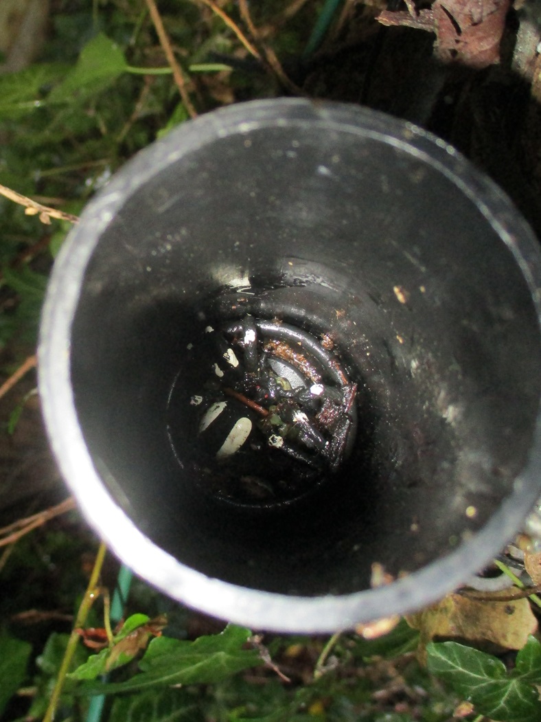
We sat in a small garden of remembrance, calculated coordinates and realised we had to head East… back to the Granite Steps. We were looking for a magnetic cache. At GZ there was only one metal object – a rather smelly drippy drainpipe. We both shoved our hands up, in, and around the drainpipe to no avail. Remember this was next to the Granite Steps, where people are busily going up and down.
Then we remembered – geocaching coordinates are great in 2 dimensions, but NOT in 3. If we climbed the steps our coordinates would still be same, just higher. Here indeed there were more metallic objects, and after a few minutes the cache was found. It took us a lot longer to remove the rancid drainpipe smell from our hands.
Dotted along the seafront, are various plaques giving details of various tragedies at sea. On a hot benign day in June, it is hard to imagine – but on a wild winter’s night the sea needs a lot more respect.
St Ives Lifeboat Station – the start point for 3 geocaches!
This was evident at the Lifeboat station – where various plaques told us of previous rescues. It was here, that three geocaches collided. We had another ad lab question, a virtual cache question to answer, and some numbers to collect for another multi. It was possible to stand in one position and find all the answers. Having completed the virtual and ad lab, we calculated the coordinates for the multi. Back in the Easterly direction – far beyond the Granite Steps we had already spent too much time at. We decided to park this cache, until the end of the day, when we were heading back to the hotel.
We were entering the tourist/working quarter of St Ives bay. Holidaymakers were out in force, buying coffees, ice creams. There was a constant throb of diesel engines in the bay. We were grateful we didn’t have a physical cache in this stretch, as it was very busy. It was also very busy outside the Sloop Inn where we answered another ad lab question. The Sloop Inn has a webcam, which rotates between the lifeboat station, its own serving tables, the pavement, the sea front and the town quay (Smeaton’s Quay)
St Leonards Church
Our next ad lab question was at St Leonards Chapel, at the entrance to Smeaton’s Quay. St Leonards is also known as the fisherman’s church. The ad lab question was quickly answered, as was collecting some numbers for our second church micro. Unusually for us, the final was in a westward direction so at least we didn’t have to backtrack along the busy seafront. We did though walk the length of Smeaton’s Quay, as there was a small, standard cache hidden at the far end. This took us a but too long to find, as the coordinates were a little off, and the hint didn’t provide an obvious clue. The end of the quay was quite busy, so we ambled around, casually looking at potential hosts, as well as admiring the boats in the bay. Eventually we stumbled across the host and discovered the cache wasn’t even hidden – just lying in broad daylight. We decided to replace as per the hint.
We headed West, passing through a maze of old-town houses and cottages. This is where St Ives fishermen lived many years ago (and may do so now).
It is also the artists quarter, and many of the small shops were selling paintings, pottery and the like. St Ives had an artist’s movement in the first part of the 20th Century and today boasts the Tate St Ives gallery. On our walk around town we saw a Barbara Hepworth statue, and artists of tomorrow learning their craft.
After traversing the old town we arrived at a small cove. Above the cove, hidden in the rocks was the St Leonards Church cache. A surprisingly tricky find. We sat on the rocks and had lunch watching swimmers, and snorkellers in the bay below.
Two more of St Ives’ bays
Rising beyond the bay is a small hill. Atop the hill is yet another church – and of course its associate Church micro cache. On the way there, we found our last ‘standard cache’ of the day, well hidden on a slightly-too-steep-a-slope for comfort. One slip of the wet grass… and it needed good shoes to prevent some sliding towards the sea. It was here, as were checking our best means of approach to this cache, we saw one of our walking leaders of the week, we had a chat… and then continued our search. Well hidden, and our reward was a heart-shaped trackable.
The last Church of the Day, high on a hill
Our searching of the last church micro cache was hampered as a couple were ‘canoodling’ right next to where we wanted to search. We found a seat, had a quick coffee, and waited.. The couple had moved on, and we found the cache quite easily. (It would have been more appropriate if the had found the heart trackable in this cache of course!).
So our westward journey was complete, all we had to do was wander back along the seafront, through the throng of tourists, passing the granite steps, heading almost back to where we found our first cache of the day, to locate the ‘Lifeboat multi’ we had parked from earlier. Hidden in a bush, behind a seat, it didn’t take too much rummaging to find.
An interesting fact… but why did they do it ?
So a great day’s caching several multis, an earth cache, a virtual, some standard caches and a 5 stage ad lab. And given the number of times we passed the Granite Steps… we know that like the back of our hand!
We were booked on a week’s guided walking holiday in St Ives, and rather than drive the full distance in one go, we opted for an overnight stay in Liskeard.
Driving down on the A303 – The Gateway to the Sun – we paused for lunch. We had sandwiches with us, and decided – on a whim – to turn off the A303 and head to Ilchester. Ideally we were looking for a nice park, perhaps with a picturesque view of the village, and a seat on which we could eat.
Sorry Ilchester, we never found a beautiful park, but this bus stop was great for lunch
We drove through the village looking, scouring, for a park, to no avail. Eventually we settled on a layby, behind a bus stop, on the road out of Ilchester. We left the car and sat on the bus stop seat.
We decided partway through our sandwiches to check for caches. Was there a ‘bus stop bedlam’ geoecache under the seat ? No.. but there was a church micro yards away. The church was tucked away from the road, and we drove right by it. We finished our sandwiches and went searching. Ugh!
A slightly grotty pole, surrounded by stinging nettles, and our geopole was in the car. Gingerly we grabbed the cache and signed the log.
We drove onto Liskeard, thinking maybe pulling off to a village – on a whim – doesn’t always work well.
We had stayed in Liskeard in 2016, and cached much of the town. Since our previous visit, a new cache had appeared. Set near our hotel it was part of the UK Toll House Series.
The Toll House was part of series of Turnpikes on the A38 from 1761. Now the A38 is a fast dual carriageway … with no tolls to pay! The Toll House is now a private residence.
A short walk from the hotel, we found the cache quite quickly before driving off into the far reaches of Cornwall.
Part two of our 2023 Ridgeway walk was from Hackpen White Horse (or more correctly the car park!) to the hamlet of Southend just south of Ogbourne St George.
The day was murky, and low cloud greeted us as we set off. We didn’t have too many caches to find on our 7 mile route and the first was some distance away at Barbury Castle.
On our way to the castle we passed several walkers, including three Duke of Edinburgh groups, each with a varied level of competence.
Barbury Castle, is an ancient hillfort dating back over 2500 years ago. It is an enormous circle surrounded by steep defensive ditches. Our path took us straight through the centre of the castle (now a grassy area). Many visitors walk above the circumference of the castle on the banks above ditches.
Our first cache was a multi, based on a noticeboard at the top of the slope near the castle entrance. Information extracted, we realised the final coordinates were back down the hill. We had a brief discussion as to whether to descend the hill, find the cache and re-climb the hill or pass the cache by. With only a handful of caches to find on our day’s walk, we opted for the extra exercise of descending and reascending the hill. We found the cache, wedged under a hawthorn bush and beside a stream was an ammo can – a great find and an old cache too – it was placed way back in 2004.
The ammo can also contained two trackables, placed there by a local caching team to us in Sandhurst, EL-JO. We took the trackables, and decided not to take them to Berkshire where EL-JO has brought them from!
Barbury Castle was quite busy, and we soon realised why. About half a mile beyond the castle is a large car park. The car park was so large there was a geocache at either end of it. (And as caches have to be 1/10 th of a mile apart this gives some indication of the car park size)
The first car park cache was exactly what a cache should be (with one notable exception).
Firstly, the reason for placing the cache. There was a great view from GZ. In fact the view was so good, there was even a toposcope telling us what we could see (or rather what we couldn’t see due to the low cloud). (As an aside, the word ‘toposcope’ neither appears in the online dictionary for this blog nor a printed version, so clearly its not called a ‘toposcope’ – wonder what it is called?)
What is this called if it is not a ‘toposcope?’
The second reason we liked the cache was the hint. Rather than ‘behind post’ or ‘behind tree’ , the hint related to the ‘toposcope’. The cache was hidden ‘in the direction of’ a place on the plaque – very clever.
Thirdly the container, Well hidden, dry and well protected.
Too well protected – as it was surrounded by stinging nettles (its only detrimental point). As Mr Hg137 has found the previous cache in hawthorn astride a ditch… Mrs Hg137 took on the stinging nettle challenge… and won!
At the far end of the car park was another cache. We went the wrong side of a fence line initially, but after a few minutes we corrected our error and quickly found the cache.
Finding this second car park cache caused us to lose our bearings a little from the Ridgeway path, and it took some time to realise the path bypassed the car park, and our caching exploits had taken us 100 yards from our intended route. Whoops!
The section of the Ridgway leading away from Barbury Castle to the village of Ogbourne St George is delightful. A gently grassy slope known as Smeathe’s Ridge. Most of the Ridgeway path we had encountered was stony and flinty and the smooth grass was a delight to walk on.
We admired the views as we descended, a point to point course to our right, horse gallops to our left. Indeed we were overtaken by a horse rider, who we saw later as she rode back up the slope.
Eventually the village of Ogbourne St George came into view and we took a detour to find the Church Micro geocache. There were 2 waypoints we had to visit, and because we were entering via the back entrance to the graveyard, we undertook the waypoints in reverse. Some dates extracted from a gravestone, then we went to the front of the churchyard, to find the remaining numbers. A lady sat on a seat near the lych gate. Her dog, Millie, growled and barked as we approached. We sidled around, found our numbers, and sidled back. All under the growling watchful gaze of Millie.
We found a seat and calculated the final coordinates – fortunately for us, back towards the Ridgeway. We stood up, and Millie had one more growling moment before we disappeared.
The cache should have been here!
Sadly our cache locating skills were remiss. The previous ‘finder’ had noted the Ground Zero was being re-fenced, and our hint item (45 degree upright) made no sense with the now vertical posts. We sent a picture of the groundworks the cache owner, who allowed us a ‘find’ as we were clearly in the correct place, but the area has been redeveloped.
We left the church area, returned to the Ridgeway, and skirted around the village of Ogbourne St George. (The river Og flows through the village, and the church named after St George).
Most of the day’s walk had been on the high Ridgeway, but now we were at the valley floor, nearer the river and the paths were muddier. Fortunately our car was parked in the picturesque hamlet of Southend, a mile of so further on so had only a short ‘mud’ walk!
A delightful 7 mile walk – with only the paucity of caches letting it down!