June 9 : The Ridgeway : Bury Down (A34) to Streatley : the halfway point

Hello, Mrs Hg137 here.

We’re walking (and geocaching) the Ridgeway, west to east, from Avebury to Ivinghoe Beacon.  Today was the seventh leg of our walk along the Ridgeway, from Bury Down, under the A34, then on to Streatley, the half-way point along the Ridgeway. It promised to be another sunny day, but, as we set off, it was warm with a pleasant cool breeze.  It would be hotter later …

A few minutes stroll along the wide, grassy track brought us to the A34.   It’s a very, very busy dual carriageway, and we were glad of the underpass.   Having walked underneath, we paused briefly to view the spot where one of our guidebooks says ‘you can cross the road here as an alternative to the underpass’ – no way whatsoever we would do that!

Under the A34

We’d found a geocache just to the west of the underpass, and there were two a little way to the east.   The first of these was some way in the air and required a little ingenuity to retrieve

Up there!

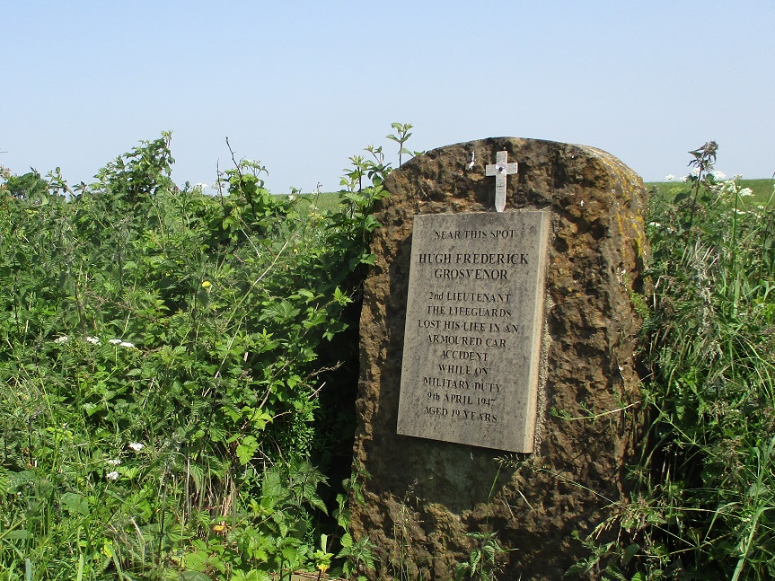
while the second was based around (but not located by) a memorial stone at the side of the Ridgeway.   It’s placed in memory of Lieutenant Hugh Frederick Grosvenor, who died here in an armoured car accident in April 1947.   He was very young …  

Gallops were now visible to either side of the path, and two racehorses passed us.  This area is horse-racing country, not far from the Lambourn valley.  The landscape was spacious and open, but with occasional trees and hedges; some of those held hidden caches, including one tree climb (not really something you’d expect on the bare chalk downs).   We were increasingly glad of the shade from any tree; the cool breeze of earlier was gone and it was getting rather hot.   This would turn out to be the hottest day of 2023 so far, reaching 27°C, and we were feeling it, with the sun blazing down from a clear blue sky and the heat reflecting up from the chalk.

We stopped for lunch, in the shade of a tree, and suddenly weren’t alone.   A van (?) came by, then two lady walkers, then a group of three male walkers.   And then we were alone again.  Very odd.

This was the last part of the exposed section of the Ridgway.  Shortly after lunch, the landscape began to change, slowly and gently.   After crossing an abandoned railway, the snappily titled Didcot, Newbury and Southampton Junction Railway, it was a hot, dusty climb up a hill to Streatley Summit, before starting our descent into the Thames valley.   Once again, we were delighted to be able to dive into the shady undergrowth to find another three caches, including some trackables (to be blogged about soon).

Abandoned railway

Starting a long, long descent into Streatley, the track became more even, then turned to tarmac; it was all very firm and unforgiving underfoot after the grassy track in the morning.   We started to pass houses, then the clubhouse of Goring and Streatley Golf Club.  It was the time of year when private gardens are opened for charity.

Eventually we emerged onto the main road leading into the village. But we had time for one more cache before we stopped: one from the Tiny Libraries series, a new series of caches based on small community book exchanges often found in old telephone boxes, bus stops and other similar structures.   This one was in a telephone box: to be more nerdy, it was an old K6 type telephone box, where the “St Edward’s” style crown cast into the box above the door shows that it was made some time after 1953. I had to be forcibly dragged away, back to the geocar, before I grabbed too many books!

Here are some of the caches we found:

August 28 :  Kennet and Avon Canal : Caen Hill to Hilperton : blood, dredging and snakes

Hello, Mrs Hg137 here.

Barge Inn, Seend
Barge Inn, Seend

Our walks along the Kennet and Avon have all been interesting, but there have not always been many geocaches to find along or close to our route.   Today promised to be different: just over twenty caches to attempt.

It started poorly: we had another try at the last cache of the previous walk.  Once again we couldn’t find it.   Oh well, never mind.  We passed the last few locks of the Caen Hill flight.  Just there, a disused railway line crosses the canal, leaving the pillars of the old bridge in mid-channel.  A cache marks the spot: ‘Over The Canal – Devizes Branch Railway ‘ so we thought we’d go and find it.   Umm, not to be.   An extract from our cache log describes what went on:

…” We hoped this was to be the first find of many in the day.  But it all went badly, horribly wrong.  First of all, we nearly got flattened by a macho cyclist on the towpath. Then it took us an age to find the path that led to the cache. We started to search among the sharp brambles. Worse followed … I got snagged by an especially fierce bramble. I put my hand down to the damp patch on my walking trousers – and it came away red. There was blood, rather a lot of it, soaking a trouser leg, sock, and both hands. The long thorn had nicked a vein.  The flow was staunched with a hanky and a spare Covid mask (second time we’ve used one for this, they work well), but not before talk of tourniquets, A&E, and abandoning the walk. The trousers, leg, and hanky were washed off under a water tap later and all seems to be well.  But we’d abandoned the cache by this time. It really hadn’t gone well.  “…

... scene of the disaster ...
… scene of the disaster …

We went on, and my trousers gradually went stiff as the blood dried.  I was an object of great interest and sniffs for every passing dog for the rest of the day; I must have smelt like dinner!   (FYI – the trousers are black so the bloodstains didn’t show.  Fortunately.)

There were fewer locks now, as the canal descended gently towards Bath, but plenty of swing bridges to slow down the boaters.   We watched, and marvelled, at some of the methods used to moor boats by the bridges (we don’t think you ram the bank either nose or stern first to moor … do you?). Several bridges had caches hidden nearby, which gave us an excuse to linger, and sometimes help with opening the bridges.  And, at one bridge, we spotted something else, a small slow-worm or snake, swimming along the edge of the canal.  Other wildlife is well catered for too: at Sells Green, part of the canal was permanently leaky, flooding adjacent fields.   The solution was to manage the flooding and turn the boggy area into a lake for wildlife.

We passed the Barge Inn at Seend and reached our first geocache series of the day, ‘Full English Breakfast’.   This series had lots of favourites on the cache logs and we were looking forward to seeing what was there.   We weren’t disappointed, they were great.  The caches all had names relating to breakfast – ‘Sunny side up’ – ‘Fried and seek’ – ‘A little shaken’ – ‘Absolute Banger’ – and each was hidden in a suitable container – a salt pot, fake egg, or plastic sausage.   Mr Hg137 found the sausage very exciting and did some extremely non-PC commenting and posing … ‘would you like to sign my’ … ‘shall I wave my … in the air’ … you get the idea!

Absolute banger!
Absolute banger!

We crossed the busy A350 on an aqueduct to reach Semington village, which is much quieter now that the main road goes elsewhere.  Just before the road bridge, there is the bricked-up entrance to the (currently derelict) Wilts and Berks Canal; like many old canals, this is under restoration, but this one has been unused for a century, there is quite some way to go.

Wilts & Berks canal entrance

Our second cache series of the day was based around dinosaurs, with a Jurassic creature attached to each of the cache containers.  Most were hidden in out of the way places, which gave Mr Hg137 the chance to re-use his ‘I wonder if they SAURUS…’ joke (several times, he has a selection of tried and tested [old] jokes, but many fewer original ones!).  A young couple were doing some bicycle repairs near one of the caches. We explained what we were doing (lest they thought we were going to steal their bikes) and showed them the cache when we had found it – great chuckles all round, they liked the container a lot.

There had been recent canal maintenance with bank clearance and reinforcement, dredging, plus attention to the brickwork around locks. I’d thought that this mostly takes place ‘out of season’ but clearly there is always work to be done, we’d passed a number of other areas being repaired along out past route.

One more cache series – based around animals (photos may well appear in our end-of-year roundup) – brought us to the end of our walk for the day, at Hilperton, on the northern edge of Trowbridge. At the end of the day we got back to our hotel in Trowbridge; this was a walking weekend, we were going out again the next day.   I had a shower and thought I would rinse out my blood-soaked, stiff walking trousers.   A good idea … but the shower did resemble a famous scene from the file Psycho

And here are just a few of the other caches we found:

March 12 : Oxshott Heath

Hello, Mrs Hg137 here.

Oxshott – a most prosperous place, home of the rich and famous

Oxshott Heath – 200 acres of sandy heath and woods – a magnet for dog walkers.

And today – a destination for us, too, as there’s a geocache series around the heath, plus more in the village.

We started at Sandy Lane car park, on the northern edge of the heath, which was busy with dog walkers and runners.   Our first cache was near a Coal Post; about 200 of them survive, in a ring around London, and they are connected with the historical collection of duties and taxes.   We admired the post, then searched around nearby for the nearby geocache.

Oxshott Heath Sand Pit
Oxshott Heath War Memorial

Once on the heath and away from the road, the character of the area changed.  We were walking through woods, interspersed with open areas of grass or sandy heath.   The cache route was mostly arranged around the fringes of the heath, in the woods, with occasional diversions into the centre to visit points of interest.  We passed a huge depression, a Victorian sand pit (reopened in WW2 for filling sandbags) and took a second detour to the war memorial.  It’s in a prominent position on the edge of a ridge, with a marvellous view.   And all around were people, and dogs … so many happy, excited bouncy dogs!  Near one cache, a man with a dog walked past … and paused … and looked at his phone. Was he a geocacher? We waited: he moved on: no, a passing muggle.

Almost all the caches were in good condition, but at one – oh dear – there was a problem. The plastic bag that should have held the log was nearby, and full of water, the cache container was lidless and full of water, with the log inside which was rather wet. Oops. We took the whole assembly off to a nearby seat for some TLC. The plastic bag was dried out (a spare Covid mask makes a good blotter!), and the log was carefully unrolled and blotted till almost dry.  We carry some spare geocaching ‘bits’ so we replaced the lid of the container and supplied a new dry log. We replaced both new and old logs (separately wrapped) back in the container so all is in better order than we found it.

And, while we were doing this, we were visited by dogs four times.   All were more muddy, or less muddy, and all thought we had food with us.   Well, we did, but it wasn’t in a wet geocache container!  All dogs went away disappointed.

At the edge of the heath, two geocache series met: a cache from the Sidetracked series (near railway stations) had been combined with the series we were doing.   We admired the daffodils at the nearby road junction, then dived in quickly to retrieve the cache during a quiet moment; woo-hoo, our fifty-sixth Sidetracked cache! Our route then took us along a track parallel to the railway tracks, and, after a little way we crossed the railway on a footbridge to take us into the village (for those who are into such things, this is the oldest surviving reinforced concrete footbridge over a railway in the UK and was built in 1910).   

Up there?  Really???
Up there? Really???

Close to the railway line is a cache in a tree.  Some way up the tree. We found the place, we spotted the cache guardian (a plastic pigeon), and we considered the climb. And bottled it. It was a long way up on a tree that was well damp from recent rain, so we decided it was a slippery climb too far.

Further into the village, and past some very expensive houses, we came to the locations of two other caches.   The first was a multicache based on the village sign, which was erected in 2019 and which features a selection of items relating to the village, including that railway bridge and a selection of sports, including tennis (lots of sports people live in Oxshott, Sir Andy Murray amongst them).  

And, just across the road, was St Andrew’s Church, the start point for another multicache … it would have been rude not to do them both, they were so close to each other!   We walked around the church in the spring sunshine to gather information for the cache coordinates, then walked some way up the road to find the cache container, our 158th Church Micro cache.

St Andrew's Church, Oxshott
St Andrew’s Church, Oxshott

Returning to the heath, we passed the tree climb again – and decided again not to climb the tree – then went back over the bridge and back onto the heath.   We had a few more caches to find, all placed around the edges of the heath, and we worked our way steadily around them while climbing gently back to the car park.  

Did we see any of the famous residents on our walk?  No-one we recognised, though we weren’t looking very hard.   We were concentrating on the pleasant walk in the spring sunshine, the views, and finding the caches.   It was a great place for a morning’s walking and caching.

Here are just a few of the caches we found:

January 15 : Ruscombe

Hello, Mrs Hg137 here.

It was a freezing, foggy morning as we parked outside the church in Ruscombe, a small village midway between Reading and Maidenhead in northern Berkshire.   We were here for geocaching, more specifically the ‘Ruscombe Byways’ series, plus three caches from the ‘Counting Vowels’ series.

We decided to start with the Counting Vowels caches. They would take more time, as each had multiple waypoints where we needed to gather information and use it to derive coordinates.   Everything we needed to know to find the first cache could be found on the neat green area, dotted with oak trees, just outside the wall of the churchyard.    We walked around; the waypoints were quickly found, the checksum consulted, and some coordinates calculated. They led to a spot in the middle of the road … hmm, something not right here … a recheck and a recalculate came up with a slightly different answer which led to a wooden object with the cache at its base.

Happy at our success (it sets the tone when start well), we left the church, passed the village pond, and walked down a track into some woods.   Google Maps describes this as ‘Ruscombe Wood nature reserve, bluebells mid-April to late May’ but, given the time of year, what we could mostly see was … mud … and more mud.   While visiting waypoints for the next Counting Vowels, cache, we slithered our way to the first cache in the Ruscombe Byways series, taking far too long to find it; we had read – and misunderstood – the hint that accompanies the cache description, so looked at everything left/right, tall/short, up/down before finding the cache.   The Counting Vowels was also nearby, and we found that, too.   

Mud !!!
Mud !!!

Three caches found, and we were doing OK.  But we had taken some while to find each of those caches, and it was still cold and grey, with the temperature around freezing point, and we were now rather colder that we had been when we set off.  We returned to the geocar and had a lovely hot cup of coffee.

Once warm(er), we set off to find the third Counting Vowels cache of the day, collecting words from the house names and other items dotted about. Mr Hg137 has friends in the village, with a suitably unusual house name, and he was ever so slightly disappointed that it hadn’t been chosen!  All clues assembled, we regrouped a little distance from the last waypoint – so we didn’t look suspicious outside a house – and found that we’d chosen our direction wisely and were stood almost on top of the cache. The remaining caches were ‘traditional’ caches so should be simpler, with a single location to visit to find the cache and sign the log. 

We crossed the railway (a main line from London to the west, with frequent trains) and walked out into the countryside, passing hatcheries full of flocks (is that the correct collective noun?) of pheasants.  It was now late morning and lot of other folk were out for a walk: alone, in pairs, in groups, with dogs.    In short spaces between walkers we found two more caches.  

And then we surveyed the path across the field to the last three caches on our list, and our spirits collectively dropped: it was a sea of mud, with puddles, and muggles wading across it in wellies.    We decided we’d had a good morning’s caching and a fine walk in the open air, but we were now muddy and cold, so we finished abruptly and set off for home.    Those remaining caches in and around Ruscombe can wait for a warmer, drier day.

Here are some of the caches we found:

September 6 : Appledore and Westward Ho!

Our last full day of our stay in North Devon – and a busy one too!

First stop was the Dartington Glass Factory, where for limited times of day, visitors can see glass being blown, shaped, cooled, checked and boxed in the factory. Unsurprisingly the factory was very, very hot and watching the craftsmen work very mesmerising.

There were no caches close to the factory, so we travelled to the village of Appledore. In former times a bustling fishing port and boat-builders. Our first cache was in sight of boat-building yard, Richmond Dock. A nearby wall proudly shows all the boats made there. Appledore has a strong connection to the Isles of Scilly, which we had visited earlier this year. The ferry link between the Cornwall and Scilly, Scillonian III, was built in Appledore, and Appledore also sends teams to the Gig-Racing World Championships on Scilly.

The cache we were looking for was in some railings, and with no-one (apparently) around, save a lady at a bus-stop, we furiously searched around. We consulted the online logs for a glint of extra information, and with it, Mr Hg137 had the ‘Eureka’ moment of knowing where the cache was. But, at that moment, some tourists arrived (we’ve still no idea how or when they arrived) and stood exactly where Mr Hg137 wanted to search. Eventually they moved off, and we moved in. Cache in hand, log signed…the rest of Appledore Harbour awaited.

Appledore was quiet, very quiet. There were people about, predominantly pensioners, presumably on a day’s excursion. Sitting on seats, drinking tea. We walked by – we were heading for the former railway station (closed in 1917) where a cache was hidden. The station and the former railway line was marked by a wonderful sculpture/mural. We initially thought the cache was attached to it, but a closer inspection of a nearby seat yielded our prize.

Then it all went wrong.

We had got hot at the glass factory, and the day was heating up to…frying our brains. (Leastways that is our excuse). Our last cache was a multi. All we had to do was collect a year from a plaque by the Lifeboat Station and undertake some very simple maths to calculate the coordinates for the final cache. One of the numbers meant multiplying 2 by 2. A child of 5 could do this. We didn’t have a child of 5 with us, just slowly frying brains. For some reason…we made the answer 8 ! (To this day, we don’t know why. We both checked it and the answer was 8).

Off we went, up a very steep hill arriving at a field boundary next to a telegraph pole. The hint, alluded to such a pole, but as we still had some way to go (to our erroneous coordinates), we didn’t check the pole. We stared field-ward. The gate was locked, and no poles anywhere to be seen. After some minutes, we moved back to the car and drove to Westward Ho! still wondering what went wrong.

(Postscript : it was late that evening we re-checked the maths, and realised the pole we had stood next to, was the host! We were within feet of the cache and didn’t look! Oh dear!)

Westward Ho!

By contrast to the quiet, sleepy nature of Appledore – Westward Ho! was vibrant, noisy and the average age must have dropped by 70 years. Car parks were full (it took us 5 circuits of a car park to get a space, which tested Mr Hg137’s parking ability to the full – remember he can’t multiply 2 x 2 – so how on earth can he park a car?!)

We walked away from the hustle and bustle to collect 3 caches. Two were puzzles we had solved before leaving home (suffice to say three words had been highlighted in each of the cache descriptions which provided a unique method of location identification). The other cache celebrated a famous author. Surprisingly, not Charles Kingsley (author of Westward Ho!), but Rudyard Kipling who attended the United Services College in the Town Centre. (The cache was called Stalky and Co, named after the book written by Kipling based on his experiences at the college).

We strode back to the sea front, and to the North-East of the main beach is a protective bank of pebbles. This protects the sand-dunes of Northam Burrows from the sea. The bank and the pebbles formed the basis of an Earthcache. We took various readings of heights, stone shapes and provided answers as to how the pebbles moved. (Proving we can do geography exams, but we can’t do maths questions!)

Our main target in Westward Ho! was the swimming pool. A tidal swimming pool. With the tide coming in, the pool would be submerged, and unswimmable in less than 2 hours. We returned to the car, and noticed….Mr Hg137 had left his swimming costume in the hotel ! (Can’t do maths, can’t carry a bag out of the hotel…)

Mrs Hg137 changed into her costume (the awkward car parking space provided surprising privacy). Mr Hg137 hatched a plan. His walking trousers were convertible. A knee-high zip would undo the bottom leg portion. So he could swim after all – in slightly too long shorts.

We arrived at the pool – surprisingly cool, and swam, waded and eventually watched the incoming tide splashing against nearby rocks. These splashes became more frequent and we knew our time in the pool was over.

An exhausting day where we learnt about glass-blowing, tested our geography skills but went to the bottom of the class in Maths !

PS We learnt punctuation too…Westward Ho! is the only place in Britain which contains an exclamation mark!

Caches found :

December 5 : Swinley Forest (South Ascot)

Swinley Forest is a large area of woodland (2,600 acres or 11 km2) stretching from Crowthorne to South Ascot. It is part of the Crown Estate, and is now a working forest of predominantly pine trees.

One of its drawbacks is there are few entry points into the forest, which means much of the woodland is quiet, unless of course you are close to one of the entry points.

We discovered four caches had been placed at the extreme East of the Forest near South Ascot, and with a handy entrance point at the end of a residential road this seemed a good mini-series for a cold December morning,

It was only when we checked the caches on our GPS before leaving home, we discovered these caches were barely a day old, and had already been found by 2 other cachers.

The first cache was at the entry to the Forest. Plenty of people walked by, as we checked the location out, finding the cache quite quickly, but re-hiding it took some time. A little too long, as the location was adjacent to a well-used dog poo bin, and even on a cold morning, the aroma was strong!

Third to find!


As we expected we were the third people to sign the log!

Our second cache was our hardest of the day. It was attached a large metallic gate, and with upright posts, horizontal supports and diagonal pipes to check it took some time. Especially with lots of dog-walkers going by every 2-3 minutes. We had cameras with us, so when a few people approached we wandered away to take an ‘aimless’ photo of tree bark, and avenues of glistening sunlight. Eventually we found the cache, very sneakily hidden.

The cache route took us along a well made up track to a delightful pond (apparently during the summer it can be bone dry) and a very obvious host. The GPS was little off, but with an obvious host.. who cares!

By now the paths were getting busier, and the dog walkers were getting more frequent.

We took a longer walk than necessary to the last cache in the series, and walked adjacent to a railway track. Several times a train went by, sometimes in plain view, other times hidden by the trackside foliage. The sun was getting higher and percolated the leafless trees forming beautiful shafts of light on the ground.

Can you spot the THREE decorations ?


The pine forest continued behind a golf club, and here we passed a pine tree with 2 baubles and a star hanging from it. So seasonal, yet so out of place!

Our last find was relatively easy hidden in some tree roots. And that should have been that. 4 brand new caches attempted, and each one found.

But…

… lurking deep in this part of the forest was a cache with a difference. It was an old cache (placed in 2007) as part of a ‘Stuffagps’ series. Here the cache owner had NOT provided the cache coordinates in latitude/longitude format but as a OS grid reference. Before we left home we had spent a few minutes (Ed : slightly more than a few !) with a well worn OS map, and determined the position of the cache and converting the OS grid reference to a GPS set of coordinates.

Hope we find the cache after all this mud!


We had done so well with the first 4 caches, we walked onto the ‘stuffagps’ cache. As we approached we checked the hint, and determined it would be up a bank away from a path. We jumped a small stream, and clambered up a bank. The GPS got closer and closer. We weren’t expecting to find this cache, given a level of inaccuracy in coordinate conversion…but there, exactly where the GPS pointed, was a container wedged under a fallen branch!

A very old log book !


We felt really happy, we had found 5 caches, 4 very new ones and 1 very old one using good old-fashioned OS coordinates!

A great morning!

A couple of caches we found :

November 28 : Sandhurst and the River Blackwater (revisited)

Hello, Mrs Hg137 here.

Lockdown 2 was still in full swing, but we thought a caching trip from home could be considered ‘daily exercise’, so we inspected the map near us and came up with three caches. Somehow all three had missed our previous caching attempts. Why?

– The first. ‘Return To Sender’, was only three months old, and, though we had passed during quite a few lockdown walks, we’d never had a pen with us.
– The second was ‘Double Celebration’, a cache which we had tried to find, and failed to find, to find just before the start of lockdown.
– The third was a multicache, ‘LKFS 40th Birthday Cache’, planted back in 2012, around the time we started geocaching. At the time we didn’t understand multicaches, left it alone, and somehow we never got round to doing it.

So, on a grey day, we set off from home, bought a weekend newspaper (good camouflage, we thought), and continued to our first target. As mentioned earlier, we’ve passed by this cache many, many times on our lockdown walks, and had even checked it was there once before. Today we were equipped for caching so we paused at GZ, made a quick grab, and signed the log. And surprise – we were not the first finder of the day, even at 10am!

Next, we started on the multicache. A pre-cache inspection of the waypoints on Google showed them all to be places we pass on our daily walks. And we’d already walked past all of them at least twice in the past week. So off we went, making notes of numbers as we passed – odd how you see the world slightly differently when you are searching for a cache! We had six stages to visit, with a number to be collected at each.

Part way through the six waypoints, we broke off to have another look for Double Celebration. This would be our third attempt. (Yes, the third …) Our first try was on November 4th, the day before the start of Lockdown 2, and we had subsequently contrived a daily exercise walk that took us past the cache site and handily gave us another chance for a futile search. By now we were feeling a bit peeved at not finding this pesky cache. A few days later, we noticed that some other cachers HAD found it. Aha! We messaged the finders and soon had a more detailed description on where to look. With additional information, and with confidence that the cache was still there and that we were in the right place, we set off (again) to the likely cache site.

This time we had more idea on what and where to look, but it still took us a good few minutes, and some minute examination, until I happened to look in just the right direction and spot something unusual. And there was the pesky cache! I was sure we had both looked there several times before! It was tiny and hard to extract, but we had succeeded at last.

Crossing back and forth over the river, from county to county, from Berkshire to Hampshire, we returned to the multicache … we resumed our search for numbers, and soon had a full set. We paused by the river to work out the coordinates. One of the waypoints is now very dilapidated and a bit of educated guesswork was needed. We set off towards the likely location, being prepared to do alternate locations if our first guess for the dilapidated waypoint was wrong. But we were correct, and we spotted the camo bag at the first attempt.

A rather dilapidated clue

A rather dilapidated clue


And then, as the cache description suggests, we took the ‘adventurous’ route back across the fields. We often walk this way in the summer when it’s drier. But at this time of year it’s definitely on the soggy side (you’d be OK with walking boots or wellies) and it can be very wet indeed after heavy rain, and you’d need more than wellies then!
Nice and dry today ...

Nice and dry today …


... but rather wet a few weeks ago

… but rather wet a few weeks ago


... right to the top of the wellies

… right to the top of the wellies


We walked back home, well pleased with our efforts. We’d walked about three and a half miles yet, we thought, had stayed within the spirit of lockdown.

Here is a selection of the caches we found:

September 27 : Dorchester on a sunny Sunday afternoon

Hello, Mrs Hg137 here.


What to do on a sunny Sunday afternoon? As we were in Dorchester for the weekend, a walk around the town, interspersed with a bit of geocaching, seemed like the answer. (We tried this, three days earlier, but were beaten back by torrential rain. Everything looks nicer in the sunshine …)

Leaving our hotel, we set off through the Brewery quarter, a new development on the site of the Eldridge Pope brewery and home to restaurants, cinemas, and some fine brewery-related statues. Here’s an article on how one of them was installed

Statue of Drummer the dray horse

Statue of Drummer the dray horse


It wasn’t far to Dorchester West station, where we found our first cache, while snacking on large and delicious late-season blackberries. Then it was off to the western side town to find some Church Micro caches. FYI – if you like caches from either the Church Micro or the Sidetracked series, Dorchester is an excellent caching place to go, it has a good selection of both types!


The first Church Micro was easy, near a large church in an almost deserted street: a nice easy find. The second was more problematic: two muggles were involved in a deep conversation right in front of the church. We ignored them and got on with looking for the numbers, stepping round them as we did so. They were still nattering away when we withdrew a short distance to work out the coordinates. Off we went to the cache location: a muggle was mending his fence, leaning on the final location to do so. Oh dear. We walked a short distance away and waited. After a bit he went away with a piece of fence, presumably to adjust it for size, and we chose that time to rush over, and speedily find, sign, and replace the cache. Phew!

What next? Oh yes, another Church Micro. (I did say there were lots in Dorchester.) We walked through the immaculate /colourful / popular Victorian pleasure gardens , admired a little surviving bit of Dorchester’s Roman wall (the western edge of the Roman town), and arrived at the church. After a bit of counting and recounting of various objects, we had some coordinates, and set off to find the cache nearby.

Dorchester's Roman wall

Dorchester’s Roman wall


And that was the Church Micros done for the day. The rest of our caches for the afternoon were spaced out along the River Frome, which forms the northern boundary of the town, just as it did in Roman times when Dorchester was Durnovaria
River Frome, Dorchester

River Frome, Dorchester


The town stops abruptly at the river, and there’s a super walk along the riverbank, with fields to one side and the town rising on the hillside on the other side. We found three caches along the river. Two of them were from the Little Bridges series, where footbridges cross the river. (Editor’s note: The Little Bridges geocache series started in 2009 to highlight small footbridges in remote parts of Wiltshire. Since then the series has expanded all over the country; to qualify, the bridge must be a footbridge too small for vehicles.) And the third is close to John’s Pond, supposedly where the only prisoner to escape from Dorchester Jail accidentally drowned ( more information here including a splendidly creepy ghost tale).
John's Pond

John’s Pond


By now, the sunny September afternoon was turning to dusk and we walked a short distance uphill to the centre of town, and off to the pub for an evening meal. Goodbye, for now, to Dorchester, it’s been fun!

Here are some of the caches we found:

September 26 : Abbotsbury and the swans

Hello, Mrs Hg137 here.

On a sparkling bright Saturday, we were out to do touristy things in delightful Dorset. There would be a few caches too, of course!

Abbotsbury Swannery opened at 10am, and we were in the village earlier than that, with time for just one cache before opening time, the appropriately named ‘Swans’ – a puzzle cache that we had solved at a few days earlier. There was a cryptic paragraph of text to consider, then some sums, which made little sense at first. An ‘aha’ moment followed, and the equation below made sense:
N50 Young Swan . Cygnet/4 (Mute Swan + 1)
W002 (Mute Swan * 2) . (Young Swan – Eggs – Cygnet/4) (Swan&Cygnet – Cygnet/3)


Then it was off to see some swans. I’ve been to the Swannery before, most recently in the late ‘90s when I helped with the Swan Census. It is just such an extraordinary experience to be handed a live, wild swan. Here’s a video of the swan census

We spent a couple of hours at the Swannery, going around the swan-shaped maze (Covid restrictions have made it into a labyrinth, but it’s still good), then the swannery itself, the duck decoys, and the prototype bouncing bomb recovered from the Fleet.

Socially distanced maze

Socially distanced maze


Bouncing bomb

Bouncing bomb


As we watched the swans, I wondered if I had seen any of them before: wild mute swans can live almost 20 years and where they are looked after (as here) it can be longer. It’s possible that some of the swans here now are children (or grandchildren) of the ones I helped to count. Or … if they were very young at the time of ‘my’ census, and quite old now, swan-wise, some of the very same swans …

Next on our pre-booked list of things to do was the Abbotsbury subtropical gardens , but we had a little while till our timed ticket, so we headed for the beach.

Chesil Beach

Chesil Beach


It was Chesil Beach – where we sat on the shingle, enjoyed a picnic lunch, and watched the sea anglers. And then, just up the road, were the gardens, which were lush and jungly, with a walk out to a superb viewpoint over Chesil Beach, over to Portland to the east, and, in the distance, Start Point in Devon to the west. We went round twice just to make sure we didn’t miss anything.


Next, in mid-afternoon, we made our way back into Abbotsbury for a bit of geocaching. First of all: a Church Micro cache: the church is adjacent to the village car park so it was a very short walk into the churchyard to locate the answers to the coordinate clues, then another very short walk to the final location. Once there, the GPS didn’t seem to point to the correct place, and nothing very close by matched the hint, but widening the search a little and a ‘cacher’s eye’ soon spotted the hiding place. (Editor’s note: as you find more caches you get an idea of the kinds of places that caches might be hidden and tell-tale signs to look out for).
Abbotsbury Church

Abbotsbury Church


Abbotsbury village

Abbotsbury village


Our next cache lay along a disused railway line, the Abbotsbury branch line Who’d have thought it – a disused railway line in Abbotsbury! And we doubted it, too, as we walked up a farm track leading to the cache. Then we turned a corner, and were unmistakeably on an old railway line, flat and straight, a shape of a platform on the right and a railway shed ahead. A short distance further along the old line was the cache, cunningly hidden amongst some old railway items.
Railway shed - where are the trains?

Railway shed – where are the trains?


Our day in Abbotsbury was now done. On our way back to the hotel in Dorchester we climbed Portesham Hill onto the Wessex Ridgeway, topped by the Hardy Monument (Editor’s note: it’s not a monument to Thomas Hardy, the writer, but instead Thomas Masterman Hardy, one of the commanders at the Battle of Trafalgar.)
Hardy Monument, Black Down, Dorset

Hardy Monument, Black Down, Dorset


We had one final cache to find, Blackdown, named after the hill on which the monument stands. We parked a little way away from both monument and cache and walked along the top of the ridge, with wide views to both north and south, and belted Galloway cattle grazing on the heathland. We came upon a structure; at first I thought it was a ruined building, but I was wrong; it’s a new artwork, the Black Down stone circle
Black Down Stone Circle

Black Down Stone Circle


Arriving at the monument, we surveyed the view out to sea, past Weymouth and Portland to the dormant cruise ships parked in Weymouth Bay, and then worked out the coordinates for the cache from items nearby. From here, we set off downhill to the cache (everything is downhill from the monument, so that’s not much of a clue!) Arriving at our calculated position, we located the cache, then slogged back uphill to the road and our geocar.

A grand day out! And here are some caches:

September 24 : Dorchester in the rain

Hello, Mrs Hg137 here.

Our long weekend in Dorset had not started well. Having left home in bright sunshine, we arrived in Dorchester with rain falling and thunder rumbling, then spent some time struggling at the hotel … how to make the lift work? (key card) … food in the hotel restaurant (no, sorry, we’re closed) … how to make the wifi work (sign in using only Internet Explorer!) … how to get into/out of the underground car park (gates / key card / lift) … how to cope with the Covid measures (aarrggh plus face masks!). After an hour or so or that, all was solved but we were both rather grumpy, so we decided to walk into town, see how things were, and maybe find a few caches too.

After a short walk, we arrived at the war memorial, ready to find the cache associated with it. And it began to rain again. Hard. We decided that inspecting the memorial closely during a rainstorm would be no fun, so took shelter outside a nearby coffee shop. The rain eased after a bit, so we continued on our way, collecting some coordinates for a Church Micro as we went (the cache was a little way away, we’d find it later).

We passed a house where the ‘Mayor of Casterbridge’ lived in the eponymous Thomas Hardy book – it’s Barclay’s Bank now. There are Thomas Hardy related items all over Dorchester, you could spend a weekend just doing ‘Hardy stuff’ – there are statues, a school / shopping arcade / pub / his houses – plus the various locations mentioned in the books http://www.dorchesterdorset.com/blog/thomas-hardy/thomas-hardy%E2%80%99s-dorchester

Dorchester High Street in the rain

Dorchester High Street in the rain


We arrived at the High Street to collect more coordinates from another Church Micro, one of many in Dorchester. The heavens opened – again – as we reached the church. We worked out the coordinates on a soggy piece of paper. The rain relented as we walked to the final location, then came down with renewed vigour while we searched for the cache. We took way too long over finding it, getting soaked, but find it we did, before we retreated to a bit of cover to wait for the rain to stop … back at the coffee shop.

This meant we were back at the War Memorial. We didn’t do the cache here before, but it was a bit drier now. We circled the memorial, collecting numbers, did the sums (which matched the checksum – great!) then found a likely hiding place nearby. A feel around, and the cache was located.

Our next cache was at Dorchester South station, so close to our hotel that it’s almost visible in the picture on the cache description. After a few laps of the platforms, bridge, and car park, we had some coordinates, and then the cache. This was the only cache of the afternoon where we didn’t get soaked either while working out the numbers or while collecting the cache, or both!

Maumbury Rings

Maumbury Rings


Just south of the station is Maumbury Rings, a Neolithic / Roman / Civil War earthwork (it’s been re-used several times) https://www.dorchesterdorset.com/maumbury.php The original route for the railway was intended to go straight through it, but was ever so slightly re-routed after a campaign to save it. It’s an impressive place, still used today for outdoor concerts, plays and the like. And a little further on was the final cache of the day – the cache for one of those Church Micros we’d solved earlier on in the rain.
It's stopped raining!
And that was it for the afternoon – we had started off soaked, complaining, under grey skies, and finished in the clear bright sunshine of an autumn afternoon. Apart from the damp pavements, it was as if it had never rained!

Here are a couple of the caches we found: