On a warm, sunny Friday afternoon in March, with spring in the air, we were out for some geocaching in and around Frimley Lodge Park.
We weren’t far from the car park when we came upon our first cache. It was easy to see – a bit too easy – part of it was in plain view – and we retrieved it and signed the log while no-one noticed (we hope). Fortunately, most attention was elsewhere as Frimley Lodge Cafe was being reopened after refurbishment, and people were enjoying the official ceremony. It was also fortunate that we weren’t here on Saturday morning at 9:00, as Frimley parkrun starts from here, and over 400 runners would have been rushing past us – it would have been much harder to be unnoticed then!
We walked across the park to the miniature railway. No trains were running today (that’s mostly at weekends), but all was neat and tidy, ready for the coming season. There’s a cache near here, from the Sidetracked series (based on train stations – large, small, or miniature – overground or underground). We worked out the coordinates for the caches quickly, then set off to find it. So far so good; but we made a terrible mess of getting there, with the GPS consistently pointing to somewhere we couldn’t reach. After one-and-a-half large circuits of the railway, frustrated and fed up, we reached a place we’d already passed by (once? twice?) and eventually finding what we sought.
Round the park we went again, passing rabbits brazenly grazing on the football fields in broad daylight, then made our way to the towpath of the Basingstoke Canal and along it to an aqueduct where the canal passes over the railway. We had a good look down at the railway: there are quite a lot of trains! Of course, we were here to look for a (very new) cache, which we found after more searching than strictly needed.
On our return leg back to the car park, our final cache was to be a 17-year old example placed in 2006 (ancient in geocaching terms!). We needed to locate some numbers and use them to generate coordinates. Our efforts were mixed: we found two different answers for one of the numbers, totally failed to find another, and got another one after thought, angst, and a lot of studying of miniature railwayana. Educated guesses gave us a series of plausible coordinates and we set about visiting each in turn. One guess took us to the centre of a car park, one nearly took us to the centre of the canal, and the third was correct. We knew we were there when we spotted something that matched information in the cache description. And that was it: a great cache, the promise of spring ahead, and a lovely park, with something for everyone.
This was it: the final section of our walk along the Kennet and Avon canal from Reading to Bath. We had about eight miles of towpath walking, snaking along the Avon valley, to take us from Avoncliff aqueduct to the junction of the canal with the River Avon in central Bath.
We were staying nearby, and our plan was to catch the train from Trowbridge to Avoncliff station, walk to Bath, then catch the train back. All started well; tickets bought, boots on, and we had time for a short wander to a ‘Sidetracked’ geocache close to Trowbridge station. (As the name suggests, this series of caches are all located at or close to existing or former stations.)
Avoncliff station – short platforms!
But … plans do go wrong … Avoncliff station *should* have been easy to reach. But we didn’t realise that the platforms are very short indeed at this station, and we were in the wrong part of the train at the crucial moment. We couldn’t get off! We had to go to Bath, wait an hour, then catch the return train. Ho hum, we reached Avoncliff, much later and much more stressed than intended.
Leaving the station, we had another ‘Sidetracked’ cache to find. While standing there, puzzled, a dog-walking muggle couple went by, saying to each other “geocachers, I reckon” as we examined a fence. We admitted guilt.
Hire boat (clear roof)
Residential boat (not so clear roof!)
Off we went along the towpath. It was wide and well surfaced, and had a fair few moored boats, many of which look to be residential. (Tip: hire boats have mostly empty roofs, there is little stored on them. Live-aboard boats typically have all sorts of stuff stored on the roof – bicycles, wood, plants, buckets, wellies, sacks of coal … )
Murhill Wharf
About a mile along the canal we reached Murhill wharf, the remains of a tramway which brought stone from nearby quarries down to the canal for transport. There was a cache here, and on our return trip we were hailed by two muggle walkers on the towpath (the other side of the canal) who asked us if we had turned back because the path was impassable. We explained the reason for going part way (a cache) and reassured them that the path is fine both sides of the canal at this point – they were planning to incorporate it into a circular walk.
We now had a couple of miles of cache-free walking. It was all very tranquil and pleasant; the canal clung to the sides of the valley above the River Avon. For the most part we were walking through trees, though there were occasional views out across the valley. The canal crossed back across the Avon at the Dundas aqueduct, and stopped to talk to the owner of a working boat which supplies coal and diesel to the boats along this stretch. Crossing the aqueduct, we (unknowingly) also crossed counties, left Wiltshire, and were now in Somerset. We were only two miles away from the point where the canal joins the river in central Bath, just over the hill, but over five miles walking along the towpath.
Coal/diesel delivery boatDundas aqueductCrossing the aqueduct
After a while we emerged onto a flatter area of ground, skirted some playing fields, and arrived at Bathampton. We stopped for a couple of lovely icecreams from the Café on the Barge, then crossed the road to the village church, St. Nicholas. Several notable people are buried in and around the church, including the first Governor of New South Wales and Walter Sickert, the artist. We had a quick look but didn’t spot any of their graves: we’d ‘lost’ an hour with all the train hassle earlier on, so couldn’t linger. We found the Church Micro cache nearby, then returned to the towpath.
St Nicholas Church, Bathampton
There were no nearby geocaches for us to find until we reached central Bath, so we just walked and watched as the city came closer and the terraces of Bath Stone houses lined the valley. We passed Undercliff urban farm, and were then among houses.
Cleveland House
Some short tunnels, no longer than wide bridges, took us under Cleveland House, originally the offices of the canal company and past Sydney gardens. We reached the start of the flight of six locks that drop the canal down to the river. There used to be seven locks, but two were combined into one, Bath Deep Lock, when work was being done on the A36. It’s the second deepest lock in the country, 19 feet 5 inches (5.92 metres) drop, and it looked scarily deep to me! (FYI: the average lock is about 8-9 feet drop.)
Bath Deep Lock
And then the canal emerges onto the river with little ceremony, through a small opening almost opposite the railway station, a not terribly auspicious spot. The Kennet and Avon goes on to Bristol, but we’d chosen to end our walk here. After some obligatory high-fives and photos, we crossed the river and headed for the station, with just time for another ‘Sidetracked’ cache to round off the day. Maybe we’ll return and finish the remaining twenty-five miles to Bristol, but, for this year at least, time had got ahead of us.
Canal meets river
It had been a great walk: we started just before Easter, as the days lengthened in spring and the weather warmed. One of our first sections coincided with the Devizes-Westminster canoe race, the world’s longest non-stop canoe race (125 miles). As the countryside bloomed into spring and then glorious early summer, we followed the Kennet up to Newbury and Hungerford, and onto the canal section. By the end of June we’d reached the summit level, just past Crofton, where we’d seen the beam engines working away, pumping water to the top. Then the weather turned hot … very hot … and our resolve to go walking melted away for a few weeks. By mid-August we’d reached Devizes and walked down the massive flight of locks at Caen Hill. The days were shortening now, and though still warm, summer was nearly over, so we needed to get on, and walked the last section, from Caen Hill into Bath over three days in late August/early September. Seventy-five miles of great walking with lots and lots to see.
Here are some of the (not very many) caches we found:
Easter Saturday is a special day on the Kennet & Avon Canal as it hosts the Annual Devizes to Westminster canoe race.
We have seen the canoeists on the Thames before, but we had not seen them on the canal.
Westminster here we come!
There are two distinct competitions. The first is over 4 days with overnight stops, the second is a 24 hour race. We hoped to see competitors in each race.
The 4-dayer had started from Devizes on Good Friday (15th April) and the canoeists had paddled 37+ miles to Newbury. Today, after a night’s rest, the canoeists were paddling from Newbury to Marlow, a distance of another 38 miles.
As is customary with our linear walks, we drove two cars to our destination (Woolhampton), parked one car up and before we drove the other car to our start (Sheffield Bottom, Theale). We checked the canal. Canoeists were coming through ! Some of them had already completed 7 miles of their 38 ! We took some photos and hurried to Sheffield Bottom.
Here the car park was heaving with support crew for the canoeists , and we suspect no canoeist had come through. We squeezed our car into a space and started our walk.
Our first cache was a multi we had calculated the previous week. As we walked towards Woolhampton, the swing bridge at Sheffield Bottom opened (holding up traffic!) to let a canal boat through.
Within yards we saw the first of the canoeists, sometimes paddling as the sole visible boat, other times a group came down together. Whether they were racing each other, or keeping each other company we didn’t know.
We were so transfixed we missed the small turn away from the canal to the cache. Eventually we realised our mistake, turned round and walked away from the canal. The cache, an old one placed in 2006, was an ammo can. Lots of goodies inside, and we left a few Lego cards.
We returned to the canal and watched as more and more canoeists went by.
The canoeists have to get out at each lock, lifting their canoe/kayak out of the water, carry it around the lock and then re-float the boat the other side of the lock. This portage system is also needed at some of the low spanning bridges. Some bridges are high enough that the canoeists can duck and pass underneath. At one such bridge we watched three crews successfully duck under… but the fourth…hit the underside of the bridge with a loud ‘thud’. Fortunately, or it appeared to us, no major incident other than a sore head.
That ‘ouch’ moment !
The swing bridge led to a gated area where a cache was hidden. We searched, and failed to find. We thought we tried all possible hiding places, but gave up. Fortunately this was part of a a series of gated caches, so we recrossed the bridge to walk to another cache in the series.
As we did so, a canal boat wanted to use the bridge. We assisted in the opening of the swing bridge and its closing. Far easier to do than we were expecting.
On the way to the second ‘gate’ cache
As we arrived at the second gated cache, we found the cache almost immediately and realised how our previous DNF could be found. We returned, and of course found the cache within seconds. Doh!
There is a definite paucity of caches on the Kennet & Avon. We had over a mile to walk to our next cache, and this was some distance from the canal. A quick easy find on an historic bridge over a tributary of the Kennet.
As we arrived back canal-side we were advised by the race marshals that the last of the 4-day canoeists had just gone through, and it would be some tine before the 24 hour paddlers would appear.
Farewell canoeists !
We soon realised how much ‘action’ the canoeists produced, as the canal went very quiet. An occasional canal boat went by, and the resident wildlife (herons.swans) decided it was calm enough to return to the canal.
Have the canoeists all gone now ?
We paused for lunch at a disused lock. When the canal was rebuilt in the late 1980s, the lock at Ufton Nervet had a drop of just 18 inches. Rather than rebuild an expensive lock, changes were made to the locks nearby to add/subtract 9 inches at each weir to make the Ufton Nervet lock redundant.
Generally the locks and swing bridges work well on the canal, but shortly after lunch, we spotted a problem. The hydraulically controlled road swing bridge had failed at Padworth. No traffic could cross the road, and no boats could pass under. A Kennet & Avon Engineer was hard at work, testing and checking the various hydraulics. As we left the bridge, we imparted what information we knew to the half-dozen or so boats arriving at the back of the queue. (The lead boat, had been there an hour, the crew had even had lunch awaiting the engineer).
Closed for road traffic……and for boats…for 2-3 hours!
Shortly after, we arrived at Aldermaston Wharf. Here there should have been a visitor centre, describing the history of the canal. It was now a tea room/restaurant. We headed on, toward the station, finding at cache near the station (part of the National Sidetracked series of caches), before returning for an ice cream. The day was hot, and we thought we deserved it!
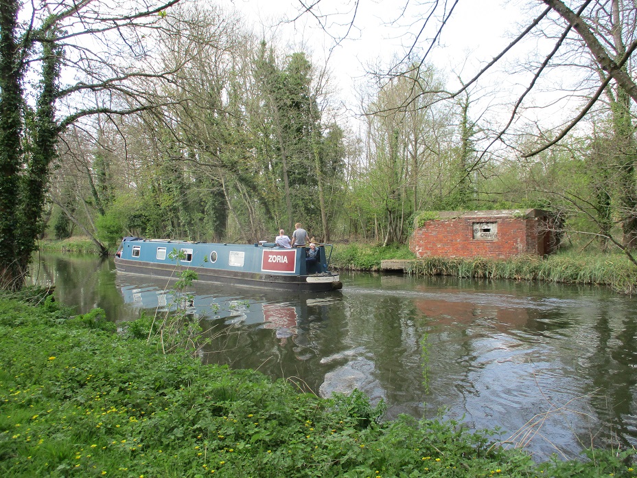
We crossed over the canal and passed by Aldermaston Lock. Inside was a boat, Zoria, we last saw in the swing bridge queue. It had decided to turn round and head West not East. We had a brief conversation with them – we discovered the swing bridge would be closed for another 2 hours !
We had a couple of cacheless miles to Woolhampton. Zoria trundled at about 2.5-3 miles an hour, we trundled at about the same speed. Sometimes we overtook it, other times, it overtook us. Partway along we were joined by a family of paddleboarders. They too went at about 2.5-3 miles an hour – so for two miles we played cat and mouse with Zoria, and cat and mouse with some paddleboarders!
We arrived at Woolhampton, and the Rowbarge pub was doing a roaring trade. This was the paddleboarders destination, but the Zoria was held up the another road bridge and lock. Nothing wrong with either, just a queue. We waited for them to leave the lock, bade them farewell and headed for home.
We had hoped to see the 24 hour canoeists pass through, but we were a about 30 minutes early for that, but we were grateful for the 6 caches found and the plethora of canoeists we did see. Three of the caches we found are shown below.
The town of Egham nestles between three major roads, the A30, M3, and M25. It is also close to the River Thames. It hosts a number of geocaches and our plan was to attempt 6 of them.
St John’s, Egham
Perhaps, undertaking urban caches one week before Christmas wasn’t a good idea. Supermarkets would be busy, and townsfolk would be rushing around trying to complete as many pre-Christmas tasks as they could, in the shortest possible time.
We decided to park in a side street a short distance away from the town centre, and avoid the crowds (and car parking fees!). Our first target was ‘Sidetracked Egham’ part of the nationwide series of caches placed near railway stations. This cache met the brief admirably as the station, and its railway crossing was visible from the cache site. We made a slight error here, as the hint alluded to ‘behind’. This should have been taken in context, ie coming from the railway station. We approached from the opposite direction and of course the hint meant nothing. Despite this we found the clever cache quite quickly.
Egham Station
Our next cache was as close to the Town Centre as we got. The cache was hidden in a churchyard. Quite how permission was granted, we don’t know, but this was our second graveyard cache in 2 months. Our problem was the exposed nature of the host, a glorious yew tree.
The church was open, and a nativity play was being rehearsed, and angels and shepherds sat glumly awaiting their moment. The yew tree was close to an intersection of paths used by shoppers and nearby, in plain sight of the cache, were volunteers tidying the graveyard. We grabbed the cache, walked on a few yards, signed the log, and replaced with almost indecent haste.
On the way to the third cache
Our third cache was a puzzle cache based on Shakespearean quotes. Some of the answers were homonyms of numbers e.g ‘WhereFOUR art thou Romeo’. We solved the puzzled relatively quickly by thumbing through our Complete Works of Shakespeare.
A noisy place for a DNF !
To find the cache we retraced our steps to the railway, and headed closer to the M3. We spotted the host quite quickly, but sadly didn’t find the cache. The previous cacher had also DNF’ed the cache, but other finders had remarked on its ‘sneaky’ container. Too sneaky for us.
Our spirits fell even further at the next cache – a tree climb. We were expecting a fairly simple tree climb, as the terrain level for the cache was a 2. Most tree climbs we’ve seen have been 3, 3.5 or higher. We were expecting to climb perhaps 2 branches, reach and grab the cache and move on. This cache though was 15 feet high. The first 2 branches were easy-ish to ascend, but to get to branches 3-6, a slim sylph-like body was needed to squeeze between 2 upright branches. This is easy for a thin, skinny teenager wearing a T shirt in summer, but Mr Hg137’s middle-aged frame combined with several winter layers, made this impossible. Mr Hg137 opted out after the third attempt.
Up there ? Really ?
Our last 2 caches were much closer to the car. The first was odd for a couple of reasons. Many people had struggled with the cache, but in midwinter after leaf-fall the cache was very, very visible. What was also odd, was the location – behind a seat. The seat had no purpose. No view, no bus stop, and the road it was next to didn’t lead to many houses so no need to a halfway-breather-stop-seat.
A seat…but its not clear why its there !
Our final cache was hanging in some street furniture. We arrived at the ‘furniture’ at the same time as another family so Mr Hg137 simulated a phone call as we let them pass. Once they had gone by, we pulled a piece of string to acquire the cache. These caches frequently give us pleasure, as we never know how long the string is, or what the final container will be. We were disappointed at this cache. Waterlogged, dirty and the type of container that gives geocaching a bad impression.
Six caches attempted, four found but a feeling of disappointment as the quality of hides and containers of the last two caches won’t inspire us to return. Sorry Egham.
Hello, Mrs Hg137 here.
For once, we had a non-exercise, valid reason to be out of the house. For the first time ever, we’d both been offered flu vaccinations (we thought we were too young to qualify, but never turn down a good offer…) so we went off and got jabbed. So there we were, in central Sandhurst at 9am. It seemed a good idea to do our daily walk from here, so we could go on a different route, as we’ve walked everywhere near our house many times by now. Coincidentally, a GPS had found its way into Mr Hg137’s pocket, loaded with a nearby, unfound geocache. How fortunate!
We followed the arrow suggested by the GPS, which – of course – directed our daily walk past the location for this cache. And, equally coincidentally, we’d done a little research beforehand. We don’t know why, but we often struggle to find the caches set by these cachers (VR7)’s caches, so we had read every word of the cache description, had memorised the hint, read all the logs, looked at any pictures, and were as prepared as possible before we approached the area.
Our GPS tried to point us onto the railway tracks, but we knew from the cache description that it wasn’t on railway land – and we weren’t planning to climb any fences or embankments today. We watched a train stop at the station, then a careful look round showed us a location which could be correct, and further investigation confirmed it. Soon we were holding the cache in our hands. Brilliant! And, though were not showing any pictures, it was a cunningly disguised and well hidden cache; muggles must walk by here daily, with the cache hiding place in full view, and simply not spot it.
Having signed the log and replaced the cache container in its hiding place, we continued on our walk, round some bits of Sandhurst we haven’t visited recently, then back along the main road to the geocar. An hour’s exercise well spent!
What to do on a sunny Sunday afternoon? As we were in Dorchester for the weekend, a walk around the town, interspersed with a bit of geocaching, seemed like the answer. (We tried this, three days earlier, but were beaten back by torrential rain. Everything looks nicer in the sunshine …)
Leaving our hotel, we set off through the Brewery quarter, a new development on the site of the Eldridge Pope brewery and home to restaurants, cinemas, and some fine brewery-related statues. Here’s an article on how one of them was installed
Statue of Drummer the dray horse
It wasn’t far to Dorchester West station, where we found our first cache, while snacking on large and delicious late-season blackberries. Then it was off to the western side town to find some Church Micro caches. FYI – if you like caches from either the Church Micro or the Sidetracked series, Dorchester is an excellent caching place to go, it has a good selection of both types!
The first Church Micro was easy, near a large church in an almost deserted street: a nice easy find. The second was more problematic: two muggles were involved in a deep conversation right in front of the church. We ignored them and got on with looking for the numbers, stepping round them as we did so. They were still nattering away when we withdrew a short distance to work out the coordinates. Off we went to the cache location: a muggle was mending his fence, leaning on the final location to do so. Oh dear. We walked a short distance away and waited. After a bit he went away with a piece of fence, presumably to adjust it for size, and we chose that time to rush over, and speedily find, sign, and replace the cache. Phew!
What next? Oh yes, another Church Micro. (I did say there were lots in Dorchester.) We walked through the immaculate /colourful / popular Victorian pleasure gardens , admired a little surviving bit of Dorchester’s Roman wall (the western edge of the Roman town), and arrived at the church. After a bit of counting and recounting of various objects, we had some coordinates, and set off to find the cache nearby.
Dorchester’s Roman wall
And that was the Church Micros done for the day. The rest of our caches for the afternoon were spaced out along the River Frome, which forms the northern boundary of the town, just as it did in Roman times when Dorchester was Durnovaria
River Frome, Dorchester
The town stops abruptly at the river, and there’s a super walk along the riverbank, with fields to one side and the town rising on the hillside on the other side. We found three caches along the river. Two of them were from the Little Bridges series, where footbridges cross the river. (Editor’s note: The Little Bridges geocache series started in 2009 to highlight small footbridges in remote parts of Wiltshire. Since then the series has expanded all over the country; to qualify, the bridge must be a footbridge too small for vehicles.) And the third is close to John’s Pond, supposedly where the only prisoner to escape from Dorchester Jail accidentally drowned ( more information here including a splendidly creepy ghost tale).
John’s Pond
By now, the sunny September afternoon was turning to dusk and we walked a short distance uphill to the centre of town, and off to the pub for an evening meal. Goodbye, for now, to Dorchester, it’s been fun!
Hello, Mrs Hg137 here.
Our long weekend in Dorset had not started well. Having left home in bright sunshine, we arrived in Dorchester with rain falling and thunder rumbling, then spent some time struggling at the hotel … how to make the lift work? (key card) … food in the hotel restaurant (no, sorry, we’re closed) … how to make the wifi work (sign in using only Internet Explorer!) … how to get into/out of the underground car park (gates / key card / lift) … how to cope with the Covid measures (aarrggh plus face masks!). After an hour or so or that, all was solved but we were both rather grumpy, so we decided to walk into town, see how things were, and maybe find a few caches too.
After a short walk, we arrived at the war memorial, ready to find the cache associated with it. And it began to rain again. Hard. We decided that inspecting the memorial closely during a rainstorm would be no fun, so took shelter outside a nearby coffee shop. The rain eased after a bit, so we continued on our way, collecting some coordinates for a Church Micro as we went (the cache was a little way away, we’d find it later).
We passed a house where the ‘Mayor of Casterbridge’ lived in the eponymous Thomas Hardy book – it’s Barclay’s Bank now. There are Thomas Hardy related items all over Dorchester, you could spend a weekend just doing ‘Hardy stuff’ – there are statues, a school / shopping arcade / pub / his houses – plus the various locations mentioned in the books http://www.dorchesterdorset.com/blog/thomas-hardy/thomas-hardy%E2%80%99s-dorchester
Dorchester High Street in the rain
We arrived at the High Street to collect more coordinates from another Church Micro, one of many in Dorchester. The heavens opened – again – as we reached the church. We worked out the coordinates on a soggy piece of paper. The rain relented as we walked to the final location, then came down with renewed vigour while we searched for the cache. We took way too long over finding it, getting soaked, but find it we did, before we retreated to a bit of cover to wait for the rain to stop … back at the coffee shop.
This meant we were back at the War Memorial. We didn’t do the cache here before, but it was a bit drier now. We circled the memorial, collecting numbers, did the sums (which matched the checksum – great!) then found a likely hiding place nearby. A feel around, and the cache was located.
Our next cache was at Dorchester South station, so close to our hotel that it’s almost visible in the picture on the cache description. After a few laps of the platforms, bridge, and car park, we had some coordinates, and then the cache. This was the only cache of the afternoon where we didn’t get soaked either while working out the numbers or while collecting the cache, or both!
Maumbury Rings
Just south of the station is Maumbury Rings, a Neolithic / Roman / Civil War earthwork (it’s been re-used several times) https://www.dorchesterdorset.com/maumbury.php The original route for the railway was intended to go straight through it, but was ever so slightly re-routed after a campaign to save it. It’s an impressive place, still used today for outdoor concerts, plays and the like. And a little further on was the final cache of the day – the cache for one of those Church Micros we’d solved earlier on in the rain.
And that was it for the afternoon – we had started off soaked, complaining, under grey skies, and finished in the clear bright sunshine of an autumn afternoon. Apart from the damp pavements, it was as if it had never rained!
Our South Downs adventure continued with a short, and relatively cacheless section between Bignor and Amberley.
We had a mini-break planned staying at the HF Holidays property in Abingworth, 6 miles North of Amberley and we planned to use Friday/Saturday/Sunday/Monday to progress our long distance walk.
Nice, gentle start to the day
Bignor car park mid-morning on a Friday was quiet. We were grateful for this as there is a steep, winding road to the top from the village of Bignor in the valley. We took in the slightly misty view and set off. Bignor car park is just 50 feet from the top of Bignor Hill, and so after 15 minutes we had reached our high point of the day! Downhill the rest of the walk (… probably)!
Murky view of the Weald
Near the top is a mounting block, known on all maps, as Toby’s Stone. It is in memory of James Wentworth-Fitzwilliam, a former secretary of the local hunt. There is often a fine view here, but the day’s mist shortened the visibility considerably.
Toby’s Stone
The South Downs Way continued with open views over the Weald to the North, the Southern views were hampered by the large area of woodland known as Houghton Forest. We descended down a steep, sharply turning, rutted path, and as we tottered downhill, a couple of cyclists zoomed by. We then had another hill to climb (so much for downhill all the way, hope Mrs Hg137 doesn’t notice). Our first cache of the day was at the far end of Houghton Forest. What a contrast to the airy views…the dark forest. Being woodland our GPS wouldn’t settle, and we wandered on forest tracks for a few minutes trying to get the GPS lower than 20 feet.
Houghton Forest
We couldn’t! But as we looked around in exasperation, we saw a tell-tale pile of flint, and the cache underneath.
We returned back to the South Downs Way, and after a short distance crossed the A29 to oversee the town of Amberley. Amberley is exactly half-way on the 100 mile footpath, so it is a welcome sight. (Or it would be, in better weather!)
Somewhere..down in the valley .. is Amberley
Amberley lies on the tidal river Arun and we had to drop all the way down to the river. Fortunately the path zigzags in places, alleviating much of the slope. We crossed the river at large metal bridge, under which was our second cache of the day. There are lots of nooks and crannies in bridges, and we searched a few, before finding the cache. The mist was now turning to rain, so we hurried to Amberley. This was a shame, as the Arun river is pleasant to watch – an egret was picking through the mud as the tide swept in, a family of young coots bobbled from reed to reed.
Bridge over the Arun
Our destination, sheltering from the rain, was Amberley station. It was covered, had seats, and was ideal for lunch. The station mural and other station furniture provided clues to a side-tracked cache (we had solved the co-ordinates when we parked in the Amberley car park earlier). We knew the cache was nearby, so we found it, once the rain stopped.
Amberley Station
There was also another cache to find… in the ‘Fine Pair’ series (a red letter box, and red phone box near each other). It was marked as a ‘letter box’ cache, meaning there was a stamp inside for people to use. Sadly the ‘letter box’ designation meant we didn’t spot it was a multi-cache. Had we realised this earlier, we would have calculated the co-ordinates when we parked our destination car in Amberley car park. Instead we performed the calculation and discovered the cache was … back on the lower section of the South Downs Way. We had walked past the cache earlier in the day! Grr! Grr ! Grr !
The start of Amberley’s Fine Pair
We had finished in Amberley, and so drove back to Bignor using slightly different roads to the one we had planned. We managed to find a layby, close to the South Downs Way, and after a short walk, retrieved the letterbox ‘Fine Pair’ cache. However the stamp and, in particular its ink, had leaked. The inside of the cache was stained blue, the log sheet was blue, and after only a few seconds of handling the cache, Mr Hg137’s fingers were blue too! Yuk!
So four caches found between Bignor and Amberley, but we had two more caches on our radar.
Between Bignor and Amberley are two car parks. Both of these yielded caches – one a simple, straightforward find. The other required the solving of a puzzle and a short woodland walk.
On route to our final cache of the day
We finished our day with 6 cache finds, wet from the rain and covered in blue ink. Our spirits were lifted when we drove to our holiday base just in time for a very welcome, and warming, cream tea.
After a gap of four weeks, we returned to our epic walk from Sandhurst (Gloucestershire) home to Sandhurst (Berkshire). This section was quite a short one, between Fairford and Lechlade, mostly through the Cotswold Water Park.
Parking one geocar in a layby near Lechlade, we stopped just long enough to find a cache there, then drove to Fairford in the other geocar. There’s a superb free car park close to the church, so we parked there and started our journey by crossing the road to visit St Mary’s Church. It’s a big church, funded by the wool trade, with superb medieval stained glass windows, the only complete set in the country https://en.wikipedia.org/wiki/Fairford_stained_glass Our plan was to collect information needed to solve the Church Micro cache associated with the church, have a quick look at the glass, find the cache, and be on our way. It didn’t quite work out like that …
Entering the church, a steward handed us an audio guide which detailed all sorts of things about the windows and the church. It would take well over an hour to see everything – there are 28 windows, and other things. But we needed to get on, and get walking. We compromised and looked at a few selected windows, found the information and left. (Editor’s note: we didn’t have time to do justice to this church interior but it is very well worth visiting and spending a while just looking at the windows; each one contains a wealth of detail and symbolism well covered in the audio guide.)
Leaving the church, we went to look for the cache, which was located very close to where the car was parked. Or should have been. Some nettle stings later, we abandoned our search, and finally set off. Oh dear, it was rather later in the day than we had intended. We walked through the town, skirted some building work, and set out along the track of an abandoned railway, now a path http://www.fairfordbranch.co.uk/Fairford.htm There’s a cache along here too, one from the ‘Sidetracked’ series. (Editor’s note: geocaches really do help with finding a route, we would have struggled to find this path without that location to guide us.)
After a bit, we reached the water park and followed a selection of paths leading round the lakes. Once again, it didn’t go to plan … the lakes are still being dug out, so the map doesn’t match what is on the ground … and we couldn’t find several of the caches we were looking for. They were part of a series planted by a local Scout troop to get their geocaching badge, but we suspect that the interest wanes a bit once the badge is achieved, and the caches aren’t maintained as well as they could have been.
Some day soon, this will be houses …
After some bumbling about we arrived at the edge of a housing development in progress, https://www.thelakesbyyoo.com There was a footpath somewhere, but we couldn’t spot it, and there were forbidding signs warning of dire consequences for any trangression. We approached a Gurkha security officer, asked the way, and were efficiently, promptly, and politely given a map (maybe we weren’t the first to ask). Emboldened, we set off, talked our way past some burly security guards, using the map as a talisman, clambered through a live building area, close to a digger, waving the map as a pass, and found our way onto a road leading through the already-built bit of the estate. There were some very large and very expensive houses here, but it didn’t do it for me: some of the lakes were a rather strange colour, and the buildings were a bit “Thames Valley Park” meets “Center Parcs”. I was glad when we emerged onto the Thames and Severn Way, leading us towards Lechlade.
Strange water colour?
Almost immediately we were finding caches from another series, the SSS / Seven Stile Stroll, which led us nicely into Lechlade, with only one failure among the five we attempted. Part way along the path we stopped for a welcome coffee break – we couldn’t stop in the building site/housing estate – and watched a small number of escaped sheep frolicking at the other side of the field. They spotted us, became embarrassed, and sheepishly slunk back to their field …
Lechlade
The path ended at the edge of Lechlade and we were soon in the town centre, it’s not a huge place. There are some quirky things to be seen – an all-year round Christmas shop, and a five foot high blue fibreglass hare being just two of them. A large blue hare? Why? Dunno. We went to the church, had a quick look inside – very pleasant, but not on the scale of Fairford – then worked out the answer for the Lechlade Church Micro which was, of course, a place that we had passed as we walked into the town. Then it was just a short walk along a tree-lined path out of town and we were back at the geocar; we’d been here before in March 2015 when we were walking the Thames Path.
It’s Christmas all year in Lechlade….
… and giant blue hares live in Lechalade too…
We drove back to Fairford to collect the other geocar. We were, once again, very close to the first cache of the day, which we didn’t find earlier. Once again, we braved the nettles. And this time we found a cache! (Editor’s note: when logging the cache, we found that it had been replaced, during the day, with the cache owner’s permission, so we hadn’t missed it on our first visit.)
And here, as ever, are some of the caches we found:
Our last day on the Isle of Wight and a very, very cold one. The “Beast from the East”, a cold Easterly wind, blew all day and although there was no rain or snow, the temperature was very low indeed. Lovely late winter sunshine but bitterly cold.
All Saints, Ryde
There are many caches in Ryde. Our plan was to spend the morning on the outer edges of the town away from the sea. Here, we hoped, and indeed it proved, Ryde’s buildings would protect us from the wind.
The afternoon we cached along the sea-front walking East (and into the wind) and when we got too cold to go on we would head back Westwards to warm up.
With hindsight, our first cache of the day should have been our last, as it was inside.
Inside a church.
We were undertaking a Church Micro Multi based inside All Saints Church Ryde. Frequently with church micros the questions (if there are any at all) are based on exterior noticeboards or gravestones. Here all but one of the answers could be found inside the church. And what a church!
Affectionately known as “The Cathedral of the Island”, the church was designed by Sir Gilbert Scott (who also designed many London landmarks). The foundation stone was laid by one of Queen Victoria’s daughters. The multi took us around various key locations in the church – the font, a beautiful stained glass window, various side chapels, the sanctuary and pulpit. At each location there was information to count or find, and after 40 minutes studying the church in detail we had the co-ordinates of the location for the cache. Here we had a quick find – but our memory will be the sumptuous interior of a wonderful church which many visitors to the Isle of Wight probably never know exists.
Our second cache of the day, another church micro was closer to Ryde Centre.
No clues to find this time, just a simple cache hidden in neighbouring street furniture.
Near to this cache was another multi, with clues set, we thought, IN a garden of Remembrance.
However the garden gates were locked so we couldn’t enter. We’ve subsequently discovered we could have found the cache information without entering the garden – doh!
We walked away from the Town Centre for our next two caches. The first was near a Victorian Water Trough. Now Grade II listed, the lamp-post/trough sits close to a road junction with lots of street signage capable of hiding a cache. The cache was hidden behind one such sign, but right in front of a garden with a loud barking dog. We escaped very quickly once the cache had been found!
Our last find in the morning was at one of Ryde’s three Railway stations. The Isle of Wight Railway line runs between Ryde and Shanklin using (old) London Tube Trains as its rolling stock. We found the ‘Sidetracked’ cache quite easily and then waited a few minutes for a train to arrive!
Here comes the train!
Our last cache of the morning we couldn’t attempt. The cache was hidden behind a seat. However the seat was occupied. We waited as inconspicuously as we could for 10 minutes (sheltering from the cold). But no joy, the person didn’t move! Even worse they were joined by a friend as well as a local caretaker! A Did Not Attempt does sound better than a Did Not Find !
A couple of our morning caches :
We adjourned to the sea front and our first two caches were two more ‘Sidetracked’ caches based on two different Ryde Stations. The first, Ryde Esplanade, was a multi. We had to count items from a plaque to a former, and world renowned, Isle of Wight resident. It was a good job there were two of us counting as we frequently ended up with two different numbers. Eventually we agreed on the numbers, and hence coordinates, and marched towards GZ. Here we searched for some time and failed to find the cache. We double checked our findings again from the plaque and discovered we were in the correct place.. just without the cache!
Our next ‘Sidetracked’ cache was also fruitless. This was at Ryde Pier Head, and is at the end of a half mile walk along the pier. Ryde Pier is one of Britain’s longest piers, but probably the only one which allows road traffic as well as rail traffic. Ryde Pier Head is the disembarkation point for the Portsmouth – Ryde catamaran, and the cars and rail link save the island visitors a half mile walk into Ryde. As we walked along the pier the hovercraft also left from Ryde… this pier is real transport hub!
Catamaran Arriving
Hovercraft Leaving
And so to the cache.
A bolt hidden 2 metres high.
Easy ! Nope!
We looked at every object looking for a bolt, all to no avail.
An interesting, but cacheless walk along the pier!
It was lunchtime.
We hadn’t found a cache for some time and the wind was just beginning to bite. The bus station (again next to Ryde Pier), provided shelter and a bit of warmth (Ed : by ‘a bit of warmth’, we mean ‘less cold’).
Lots of space on the beach!
Suitably refreshed, we found several caches in quick succession as we headed East along the sea front.
Sometimes the caches were attached magnetically, sometimes in flower borders.
Is there a cache here ?
The sea front was busy as despite the bracing wind, people were bravely playing on the beach, dogs were being exercised, kites were being flown. The boating lake was though devoid of people and it was here we had our next failure. The GPS bounced around, and the hint didn’t help much either – and so our rapid finding spree was at an end.
We had arrived on the outskirts of a park where two caches were hidden. One was a puzzle cache we had solved quite quickly at home (It took us longer to find the cache than solve the puzzle!). The other cache was near a small stream, which had to be crossed. Mr Hg137 jumped across, found the cache, but couldn’t open it. He threw it to Mrs Hg137 to try. Our cold, numb hands couldn’t turn the lid. Eventually we opened it, and the contents fell into the stream. We then spent a few minutes ‘fishing’ the items out of the cold water ! An easy find, but 15 minutes to open the cache and replace contents!
Can you open this ?
These should have been our last caches of the day. We wandered back to Ryde – now with the wind at our backs – and re-searched our DNFs. Still no caches to be found. We drove out of Ryde, following an odd one-way system and discovered we were driving along a road we had cached along earlier. Look ! There’s the seat! The one with cache we didn’t attempt! Mrs Hg137 was pushed out of the car, while Mr Hg137 found a car park space. Cache found, log signed ! Phew!
Last cache of the day!
So a mixed day’s caching in Ryde – three DNFs, ten straightforward finds, and a magnificent Church multi. (And two very cold cachers!)