March 17 : Frimley Lodge Park, Surrey

Hello, Mrs Hg137 here.

On a warm, sunny Friday afternoon in March, with spring in the air, we were out for some geocaching in and around Frimley Lodge Park.

We weren’t far from the car park when we came upon our first cache. It was easy to see – a bit too easy – part of it was in plain view – and we retrieved it and signed the log while no-one noticed (we hope). Fortunately, most attention was elsewhere as Frimley Lodge Cafe was being reopened after refurbishment, and people were enjoying the official ceremony.  It was also fortunate that we weren’t here on Saturday morning at 9:00, as Frimley parkrun starts from here, and over 400 runners would have been rushing past us – it would have been much harder to be unnoticed then!

We walked across the park to the miniature railway.   No trains were running today (that’s mostly at weekends), but all was neat and tidy, ready for the coming season.   There’s a cache near here, from the Sidetracked series (based on train stations – large, small, or miniature – overground or underground).  We worked out the coordinates for the caches quickly, then set off to find it.  So far so good; but we made a terrible mess of getting there, with the GPS consistently pointing to somewhere we couldn’t reach. After one-and-a-half large circuits of the railway, frustrated and fed up, we reached a place we’d already passed by (once? twice?) and eventually finding what we sought.

Round the park we went again, passing rabbits brazenly grazing on the football fields in broad daylight, then made our way to the towpath of the Basingstoke Canal and along it to an aqueduct where the canal passes over the railway.  We had a good look down at the railway: there are quite a lot of trains!  Of course, we were here to look for a (very new) cache, which we found after more searching than strictly needed.

On our return leg back to the car park, our final cache was to be a 17-year old example placed in 2006 (ancient in geocaching terms!).  We needed to locate some numbers and use them to generate coordinates.   Our efforts were mixed: we found two different answers for one of the numbers, totally failed to find another, and got another one after thought, angst, and a lot of studying of miniature railwayana.   Educated guesses gave us a series of plausible coordinates and we set about visiting each in turn.  One guess took us to the centre of a car park, one nearly took us to the centre of the canal, and the third was correct. We knew we were there when we spotted something that matched information in the cache description. And that was it: a great cache, the promise of spring ahead, and a lovely park, with something for everyone.

Here are some of the caches we found:

December 18 : Egham

The town of Egham nestles between three major roads, the A30, M3, and M25. It is also close to the River Thames. It hosts a number of geocaches and our plan was to attempt 6 of them.

St John’s, Egham

Perhaps, undertaking urban caches one week before Christmas wasn’t a good idea. Supermarkets would be busy, and townsfolk would be rushing around trying to complete as many pre-Christmas tasks as they could, in the shortest possible time.

We decided to park in a side street a short distance away from the town centre, and avoid the crowds (and car parking fees!). Our first target was ‘Sidetracked Egham’ part of the nationwide series of caches placed near railway stations. This cache met the brief admirably as the station, and its railway crossing was visible from the cache site. We made a slight error here, as the hint alluded to ‘behind’. This should have been taken in context, ie coming from the railway station. We approached from the opposite direction and of course the hint meant nothing. Despite this we found the clever cache quite quickly.

Egham Station

Our next cache was as close to the Town Centre as we got. The cache was hidden in a churchyard. Quite how permission was granted, we don’t know, but this was our second graveyard cache in 2 months. Our problem was the exposed nature of the host, a glorious yew tree.

The church was open, and a nativity play was being rehearsed, and angels and shepherds sat glumly awaiting their moment. The yew tree was close to an intersection of paths used by shoppers and nearby, in plain sight of the cache, were volunteers tidying the graveyard. We grabbed the cache, walked on a few yards, signed the log, and replaced with almost indecent haste.

On the way to the third cache

Our third cache was a puzzle cache based on Shakespearean quotes. Some of the answers were homonyms of numbers e.g ‘WhereFOUR art thou Romeo’. We solved the puzzled relatively quickly by thumbing through our Complete Works of Shakespeare.

A noisy place for a DNF !

To find the cache we retraced our steps to the railway, and headed closer to the M3. We spotted the host quite quickly, but sadly didn’t find the cache. The previous cacher had also DNF’ed the cache, but other finders had remarked on its ‘sneaky’ container. Too sneaky for us.

Our spirits fell even further at the next cache – a tree climb. We were expecting a fairly simple tree climb, as the terrain level for the cache was a 2. Most tree climbs we’ve seen have been 3, 3.5 or higher. We were expecting to climb perhaps 2 branches, reach and grab the cache and move on. This cache though was 15 feet high. The first 2 branches were easy-ish to ascend, but to get to branches 3-6, a slim sylph-like body was needed to squeeze between 2 upright branches. This is easy for a thin, skinny teenager wearing a T shirt in summer, but Mr Hg137’s middle-aged frame combined with several winter layers, made this impossible. Mr Hg137 opted out after the third attempt.

Up there ? Really ?

Our last 2 caches were much closer to the car. The first was odd for a couple of reasons. Many people had struggled with the cache, but in midwinter after leaf-fall the cache was very, very visible. What was also odd, was the location – behind a seat. The seat had no purpose. No view, no bus stop, and the road it was next to didn’t lead to many houses so no need to a halfway-breather-stop-seat.

A seat…but its not clear why its there !

Our final cache was hanging in some street furniture. We arrived at the ‘furniture’ at the same time as another family so Mr Hg137 simulated a phone call as we let them pass. Once they had gone by, we pulled a piece of string to acquire the cache. These caches frequently give us pleasure, as we never know how long the string is, or what the final container will be. We were disappointed at this cache. Waterlogged, dirty and the type of container that gives geocaching a bad impression.

Six caches attempted, four found but a feeling of disappointment as the quality of hides and containers of the last two caches won’t inspire us to return. Sorry Egham.

February 4 : Sandhurst

Hello, Mrs Hg137 here.

For once, we had a non-exercise, valid reason to be out of the house. For the first time ever, we’d both been offered flu vaccinations (we thought we were too young to qualify, but never turn down a good offer…) so we went off and got jabbed. So there we were, in central Sandhurst at 9am. It seemed a good idea to do our daily walk from here, so we could go on a different route, as we’ve walked everywhere near our house many times by now. Coincidentally, a GPS had found its way into Mr Hg137’s pocket, loaded with a nearby, unfound geocache. How fortunate!


We followed the arrow suggested by the GPS, which – of course – directed our daily walk past the location for this cache. And, equally coincidentally, we’d done a little research beforehand. We don’t know why, but we often struggle to find the caches set by these cachers (VR7)’s caches, so we had read every word of the cache description, had memorised the hint, read all the logs, looked at any pictures, and were as prepared as possible before we approached the area.


Our GPS tried to point us onto the railway tracks, but we knew from the cache description that it wasn’t on railway land – and we weren’t planning to climb any fences or embankments today. We watched a train stop at the station, then a careful look round showed us a location which could be correct, and further investigation confirmed it. Soon we were holding the cache in our hands. Brilliant! And, though were not showing any pictures, it was a cunningly disguised and well hidden cache; muggles must walk by here daily, with the cache hiding place in full view, and simply not spot it.

Having signed the log and replaced the cache container in its hiding place, we continued on our walk, round some bits of Sandhurst we haven’t visited recently, then back along the main road to the geocar. An hour’s exercise well spent!

July 20 : Penarth to Cardiff – plus an encounter with the RNLI

Hello, Mrs Hg137 here.

It was Saturday 20th July, the first full day of our weekend break in Cardiff. We caught the train to Penarth, planning to walk back to Cardiff, see the bay and the barrage, take in the city centre, and find a cache or two along the way.

After a short walk downhill from the station through pleasant parkland (they like their topiary and flowerbeds here!) we arrived at the promenade. It was high tide, with no beach visible, so we set out along the pier https://piers.org.uk/pier/penarth/ The pier is great and there’s lots to say about it:

Penarth pier

Penarth pier


– We saw the Penarth All Stars netball team in pre-season training on the pier https://www.penarthtimes.co.uk/sport/17757201.national-success-penarth-allstars-netball-club/ and a few years ago, Gareth Bale was spotted playing football there https://www.bbc.co.uk/news/uk-wales-south-east-wales-28029379 And there’s a plaque commemorating a lady from Penarth who swam across the Bristol Channel to Weston-super-Mare http://www.dai-sport.com/91-years-ago-woman-porthcawl-made-swimming-history/

– It’s 658 feet long; it can’t be longer, or it would protrude into the shipping channel for Cardiff Bay. Paddle steamers – the Waverley and Balmoral – still dock at the pier.

– It was ‘Pier of the Year’ in 2014.

– There used to be another pier at the other end of the esplanade but that was destroyed by fire.

– When there are especially high spring tides, the water is almost up to the decking on the pier.

Having lingered on the pier, we started on the caching. The first cache we attempted was a multicache, ‘Penarth Prom’. To find it, we needed to collect and count numbers from signs and plaques from various places along the seafront. Having done that, the coordinates we derived led us to a plausible place and to a spot which matched the hint (and which looks correct now we have viewed other photos). But could we find the cache? NO! Not a good start. At this time there was sudden activity at the far end of the promenade; the road closed, briefly, as the Penarth lifeboat was launched and went zooming out to sea; more about this later.

Penarth lifeboat

Penarth lifeboat


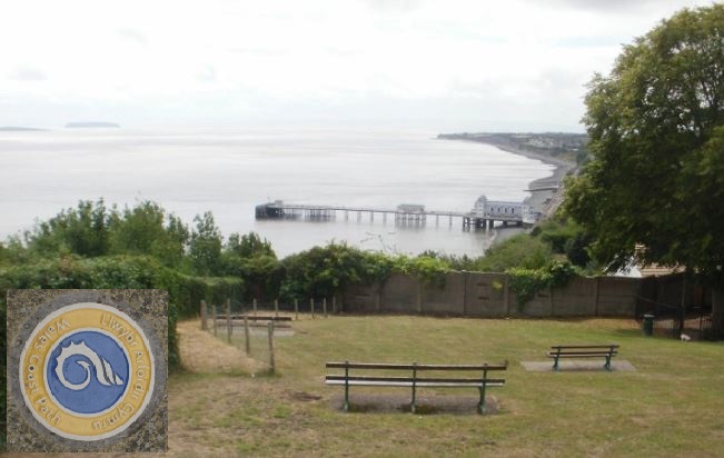
We gave up on the unfound cache and began to walk back to Cardiff, arriving at a viewpoint at the top of the cliffs with a big view back to the pier and beyond to Flat Holm and Steep Holm islands. The boundary between Wales and England runs between the islands; Steep Holm, the farthest one, is English, while Flat Holm is Welsh. Here, also, is a cache, newly placed, somewhere around a wall at the lower end of the viewpoint. That gives littles away as the concrete wall has various lumps, bumps, cracks, and fixings, and ivy trailing over and through it. We had ample time to consider all of those as we searched up and back and along the wall, sticking our fingers in myriad places, and we were just getting downhearted when I spotted something ever so slightly different, which was the cache. Hooray, a find to get us going.

There was a short, winding descent and we emerged at the locks at one end of the barrage. After crossing the three locks, each with their own lift bridge, we were about to walk away when we saw “boats” approaching the locks. Ooh – a chance to see the locks work and the bridge lift! We went back to the locks to see what would happen. And “boats” was a yacht roped to a RNLI lifeboat. Another yacht roped to another lifeboat soon followed, and then a smaller lifeboat, keeping watch. The two pairs of yachts/lifeboats manoeuvered into the lock, leaving the littlest lifeboat outside. What was going on, and why do many lifeboats? As the lock filled, the lock-keeper told us that a yacht had broken down in the Bristol Channel and was taken in tow by the Weston lifeboat. The Penarth lifeboat, which we saw leaving earlier, went to collect it to return it to Cardiff, but was called to another broken-down yacht on the way. All yachts and lifeboats then returned to Cardiff and made their way into the bay, with a bit of RNLI crew swapping as the Weston RNLI crew weren’t familiar with the locks. What excitement! Read all about it here: https://www.thewestonmercury.co.uk/news/weston-rnli-tow-yacht-to-cardiff-1-6174628

Once across the locks, we were in Cardiff. Croeso i Caerdydd! We stopped almost immediately to find the Southernmost Point of Cardiff cache, hidden on the end of the breakwater; this one was hard to find, with fingertip searches of every likely hiding place. Then followed a cacheless walk of about a mile along the barrage and the shores of Cardiff Bay. It was now warm, but quite windy, and the waves in the bay were sparkling, though doubtless the water was cold.

Total Wipeout, Cardiff-style

Total Wipeout, Cardiff-style


Part way along, we came to a floating assault course – think “Total Wipeout”! – and we watched a party of exhausted participants drag themselves from the water while the next group rushed excitedly in https://www.aquaparkgroup.co.uk/cardiff/
Norwegian Church, Cardiff

Norwegian Church, Cardiff


We passed the Norwegian Church (Roald Dahl was baptised here), and next reached outer space – the “Doctor Who Experience” had been located here until recently, and our next pair of caches had Whovian themes – “Bigger on the Inside” and “Don’t Blink”. Passing Britannia Quay, we found two more caches (at last, the total was beginning to build now, after a slow start to the day). We’d reached the Senedd, the National Assembly for Wales http://www.assembly.wales/en/visiting/senedd/Pages/senedd.aspx and decided on a quick look inside. Mistake! We had to go through security: Mr Hg137 almost had to disrobe (??!?), while I had to hand in my weapons (a Swiss Army knife and a torch): we had a look around but we didn’t feel especially welcome.
Senedd, Cardiff, outside ...

Senedd, Cardiff, outside …

... Senedd, Cardiff, inside

… Senedd, Cardiff, inside

Weapons reclaimed, we returned to the shores of the bay to look for “Goldfinger Revisited”. We weren’t quite sure what this was going to be, and were surprised to arrive at a large sculpture, the Celtic Ring http://harveyhood.blogspot.com/2011/11/celtic-ring-cardiff-bay.html The other surprise (to us, anyway) was that the area was incredibly busy, but it was a sunny weekend afternoon, down by the water, with a nearby funfair, so maybe (a few!) people are to be expected … We thought for a bit, read cache logs, hint, and description, and soon found the cache, without any of the crowd spotting us.

Celtic Ring

Celtic Ring


We continued into an area now called Cardiff Bay, but which used to be called Tiger Bay, which was a very … umm … vibrant area of the city. https://en.wikipedia.org/wiki/Tiger_Bay We stopped to find the Sidetracked cache at Cardiff Bay station. After the quick find, we stopped to regroup, around the corner, for a moment, then stepped back into the sunshine to find … some other cachers replacing the cache! Nice to meet you, new-dawn and two mini-cachers! They said they had come into town for the day, and that they had found a new cache on the barrage called “Captain Fartypants” … we had walked right past it … and the cache hadn’t been placed when we loaded the caches for this weekend. Curses!
Cachers, caught red-handed!

Cachers, caught red-handed!


A little further on, there was another cache for us to find, outside St. Mary’s Church, called “Tiger Bay Girl Was Here” – Shirley Bassey, the girl in the title, was baptised there.
St Mary's Church, Cardiff Bay

St Mary’s Church, Cardiff Bay


Then we reached the southern edge of the city centre – almost back now! – to do two earthcaches, close to each other, in quick succession: these require you to gather geological information from items in the area. So close to each other, so different in aspect: Callaghan Square was a breezy open space with fountains and skateboarders: St. Mary’s Street was party central, and maybe 5pm on a sunny Saturday wasn’t the best of times to attempt this cache. The area was quite … lively! We sat on a bench and assembled the answers, unnoticed, while hen parties, stag parties, and party parties all passed by.

And that was it – back to the hotel. A little later, after a rest and a superb Chinese meal in a restaurant where we were almost the only Europeans, there was one final cache to attempt, the Sidetracked at Queen Street station, opposite our hotel. We finished the day as we had started, with a failure. The cache is hidden somewhere along a wall around a private car park. Mr Hg137 decided to search inside the car park (foolish), but became trapped when the automatic gates shut on him (oops); luckily, he got a concierge to let him out through the foyer of some nearby apartments. A quirky end to a fascinating, but tiring day, and we had seen a huge variety of what Cardiff has to offer.

(Editor’s note: if you are in the area, the restaurant is No. 23 Chinese Restaurant 金满楼 in Churchill Way)

Here are some of the caches we found:

February 3 : A Cold Camberley Constitutional

Camberley Scultpure

It was one of those cold winter’s days. The sun was nowhere to be seen. There was a coldish breeze blowing, and the clouds were periodically producing light drizzle.

Not the most inspiring day to go cachimg, so we chose somewhere local to us, Camberley Town Centre. About 1.5 miles from where we live, this seemed ideal. If the weather got slightly worse, we could shelter in shops; if the weather got really bad we could retreat to the car and get home very, very quickly.

Fortunately we didn’t need either escape route as we undertook the Camberley Constitutional Cache. This multi-cache took us to 11 different locations near the centre of Camberley. We started just to the south of the Town Centre and had to acquire information about a Grade II listed building associated with Sir Edwin Lutyens. Now without meaning to disrespect Camberley, it is not one of the places one would naturally associate with Lutyens. A truly unexpected find !

Edwin Lutyens House

We headed North towards the Centre, passing under the railway (waypoint 2), and walked to the Station.
Here we paused, to collect our first cache of the day. Another multi, and one where we had to count bicycle racks, platforms and doors to calculate the co-ordinates for the final hiding place. Although the cache was slightly off our Consitutional route, it was only a couple of minutes out of our way. (We discovered Camberley has an inordinate number of green telecoms boxes.. and this hide was the first of three green boxes we were going to cache behind!)

We resumed our Camberley Constitutional walk by passing the Theatre, Council Offices and Museum (a further three waypoints here). Then our route turned in toward the Town Centre, where we had a store name to verify (here, we almost miscounted the letters on the faded sign).

Up to now our route had been quiet, a bit bustly, but then we had to walk along the A30. A major traffic route, and the noise level increased substantially. We collected another waypoint before crossing to the road to Camberley’s War Memorial.

This stands outside the main gates of the Royal Military Academy (Sandhurst). (Interestingly the rear entrance to the RMA is in Sandhurst, Berkshire yards from our house, but the main official entrance is in Camberley, Surrey !). At the War Memorial we had to find the lengths of various names, and derive a set of co-ordinates for our third multi of the day. We made a school-boy error here, as the cache owner had given a checksum for the final co-ordinates for the cache, but we calculated the check-sum on the numbers we had found. We double and indeed triple checked our numbers (to no avail) before heading off to a possible location where we did find the cache! It was only after emailing the cache owner afterwards did he point out our inability to read instructions!

Royal Military Academy, Sandhurst


We had one more waypoint on the Camberley Constitutional to find on the A30. It was at a Church where a standard cache was also hidden (and if truth be told we took a bit too long finding the cache – unearthing cold, wet leaf litter on a freezing day was not our best strategy). The Camberley Constitutional route took us past several churches – some modern, some much older. St Tarcisius Church was erected 100 years ago to commemorate those soldiers trained at the RMA who were killed during the First World War.

St Tarcisius Church


Our Constitutional cache then took us away from the A30 (passing the Sports Centre – another waypoint) and through a park. We took the wrong exit out of the park (we mis-interpreted the term ‘diagonally across’ far too literally) and ended up heading back towards the A30!

Camberley Sculpture

Whoops! We realised out mistake and soon found ourselves collecting the final waypoints on our walk. A swift calculation later and we arrived at the cache! Although the container and its hiding place were not special the tour around Camberley certainly was. Caching really is educational!

We had one more cache to collect. We had solved a puzzle cache before we left home (part of the Surrey School Days series). We correctly identified a person who had been educated in Surrey, before becoming famous in a particular film role, and is still on our TV screens today). We drove 2 miles around the residential streets of Camberley, but a shorter route – had Mr Hg137 turned the car around ! – was only 0.5 miles!

A very entertaining, if cold, afternoon in Camberley. Three multi-caches, one puzzle cache, one standard cache and two very cold cachers! And the rain kept off too!

May 26 : Bodiam Castle

Hello, Mrs Hg137 here.

Bodiam Castle

Bodiam Castle


We had just finished our unofficial, self-made long-distance path from Sandhurst (just in Berkshire) to Sandhurst (just in Kent). Woo hoo! Mission accomplished, that left a hot, sunny May afternoon free for enjoying ourselves, and we moved a mile or so from Sandhurst to Bodiam, just back over the border in Sussex.

Bodiam Castle really looked the part of a castle, surrounded by a moat, standing square with towers at the corners and gates https://en.wikipedia.org/wiki/Bodiam_Castle It was built in 1385 and still looks very complete from the outside. Inside it’s more of a shell but there are rooms and towers to visit and steep spiral staircases inside turrets to climb to the battlements. Once up top, there’s a view out across the nearby countryside with its vineyards, and down into the moat with its large and numerous carp.
Fish!

Fish!


After about two hours we had ‘done’ the castle quite thoroughly, had climbed every uneven winding staircase, walked along the battlements, and visited every room. After a cup of tea, time for some caching! Our first cache lay uphill from the castle, along the Sussex Border Path, at the side of a vineyard. ‘Swine Bovine Equine’ was a very old cache, placed in March 2002 (that is extremely venerable in caching age!) and its name comes from the figures decorating the weather vanes of three nearby oasthouses.
Swine, Bovine, Equine

Swine, Bovine, Equine


There is more history in the grounds of the castle, though much more modern, a World War II pillbox (to be more precise, a pentagonal FW3/28A variant, brick-skinned!) and there is a cache based on that. (More information on this pillbox can be found on this blog: http://wwww.pillbox.org.uk/blog/216726 ) We’d done the research beforehand, so didn’t need to look very closely, and the cache container can be found a little way away, outside the castle grounds. The cache description says that the National Trust expect visitors to pay before entering the castle grounds and walking past the pillbox; we did that anyway as we were visiting the castle … but that path is also a public footpath, part of the Sussex Border Path, and I think you could walk along that anyway, without paying.

Past the castle and moat, we turned uphill away from the castle to look for another cache, hidden behind a decorated village pump, which is also a war memorial. More about this can be found here: http://www.roll-of-honour.com/Sussex/Bodiam.html It was somewhere we had driven by earlier, almost without noticing, and would not have stopped. While researching for this post, I came across a comment on the cache logs which was written on the logs after our visit … ‘Message from a Bodiam resident THIS IS A WAR MEMORIAL Show respect’ I agree: we should, and did, show respect; but from another viewpoint, the cache brings visitors who would not stop here otherwise, and who keep alive the memories of those commemorated there.

Bodiam war memorial

Bodiam war memorial


But there is more to Bodiam than the castle: just over the River Rother lies a station, which forms one end of the Kent & East Sussex railway, the other end being at Tenterden https://www.kesr.org.uk It had its heyday during hop-picking times, and is now a heritage steam railway. And, as there was a station, there was a cache to be found there, from the ‘Sidetracked’ series. Could we find it? We gave it a very long search, staring at every possible place it could be hidden, including a very suspicious large stone tucked behind a fence post. But we couldn’t find it … no-one else has found it since, and it’s been temporarily disabled. It goes missing quite often, according to the logs.
Bodiam Station, K&ES railway

Bodiam Station, K&ES railway


It was now about 5pm, and still very hot, and we were beginning to wilt, as we had been out walking / castle visiting / caching all day in the sunshine. We had just one more cache to attempt, sort of on the way back to the car. Once back at the bridge over the River Rother, we then diverted along the path along the riverbank. A little way along was the final cache, ‘Castle View’, which really did mark the spot for a splendid view back to the castle nesting amongst trees just above the valley. Facing the other way, there was also a splendid view of the station and railway: A well chosen spot indeed.
River Rother

River Rother


And that was it for the day: time to head back to the hotel for a rest, a shower and a meal, in no particular order.

Here are some of the other caches we found:

May 24 : Sandhurst to Sandhurst (Kent) : Stonegate Station to the Kent border

Hello, Mrs Hg137 here.

Part way through our week’s holiday in Hastings, we took a day away from sightseeing to tackle the penultimate leg of our unofficial, self-made long-distance path from Sandhurst (just in Berkshire) to Sandhurst (just in Kent). Today’s route was from Stonegate station to just a few yards from the Kent border near Hawkhurst Fish Farm.

Stonegate station

Stonegate station


Leaving the station car park (where do all the passengers come from? It’s in the middle of the countryside), we set off roughly parallel to the railway, along a farm track, stopping to talk to the farmer, and then on along a grassy path at the edge of a field to find our first cache of the day, part of the ‘Burwash Bash’ series. And it was a pretty good cache, hidden away inside the innards of a plastic creature (think ‘rivet’, ‘rivet’, ‘rivet’). Just as we replaced the cache two people came along, armed with maps and clipboards. They were researching a long-distance route of their own. We explained about our own mission, and about what we were doing, lest they thought us suspicious/mad, pointing vaguely in the direction of the cache.
What are these for?

What are these for?


We followed the two walkers, who got ahead when we stopped to find the next cache, in woodland, hidden in a fallen tree among a selection of numbered insect traps/nests? we didn’t know what they were for. Further on, we briefly crossed the railway tracks to find a cache in a gate, then returned to walk through woods, where we found … a dump of abandoned model houses … very odd.
... And why are these here?

… And why are these here?


A little further on in the woods, we came across a couple putting pieces of red tape round some of the trees. They left when we appeared. There are some strange people and things in this bit of Sussex! Two more caches were found, the first overlooked by a passing runner, and the second watched from above by a gang of railway workers. We had seen about twenty people so far; this wasn’t the quiet path in the country we had expected!
Watch out for trains!

Watch out for trains!


We turned uphill away from the railway and things went slightly wrong. There was a footpath diversion, but it was only signposted from the other direction, and, unknowing, we emerged onto a road in a place we weren’t expecting. Then we couldn’t find where the diverted path continued, and accidentally walked down a farm drive before re-finding the path. We were only certain we were back on the right path when we found the next cache. We carried on uphill, finding caches as we went and dealing with more bits of uncertain path signage. At least the series of caches was keeping us on the right route!
Signpost to ... where?

Signpost to … where?

Where's that path?

Where’s that path?

Eventually we emerged onto a road, and paused for a drink of water. We now had a long, cacheless, hot walk along roads to Hurst Green. It was time to step away from the ‘Burwash Bash’series, so time for a quick tribute to this series; we’d found thirteen caches from the series and it’s in beautiful countryside, with a variety of containers and methods of hiding; all were well maintained, with clean, dry logs in an inner pot in the cache container. Here are a selection of caches from this excellent series, in no particular order:


What a varied series!

OK – advert over – we stepped onto the tarmac, on a hot day with the early afternoon sun reflecting from the road, and walked along the road and up the hill into Hurst Green. Two and a quarter miles later, we sat on a seat in the village for another drink of water.

Somewhere in Hurst Green ...

Somewhere in Hurst Green …


Refreshed, we walked up to the A21, and found our first cache for a while just up the road. That done, we crossed the busy road, set of down a track, and were almost immediately away from the busy village and in open country once more. It was just a couple of miles more back to the car at the end of the walk, and there was one more cache to find, about midway. Called ‘Pond Bay’, it was to be our 1900th cache, so we spent quite a while looking for it; it hadn’t been found for 9 months, since August 2016, and it wasn’t quite where the GPS should have been … but find it we did.
Long lost cache, needing some TLC

Long lost cache, needing some TLC


Then it was just a mile back to the geocar as the afternoon cooled. Fifteen caches found, and just one more walk to go until the end of our quest.

May 23 : Winchelsea, Rye and Lydd

Our previous day’s caching had been quite long with lots of sightseeing and a double caching trip. We therefore decided to have a more restful day… in the car.

Rye

Rye – Mermaid Street

We would drive to Winchelsea, wander around, grab a couple of caches. Drive to Rye, do likewise. Similarly in Lydd. If time permitted we would even visit Dungeness. And, unusually for us, we more or less, stuck to this plan!

So first stop.. Winchelsea.

Winchelsea

Winchelsea Church

Winchelsea lays claim, or so its says on Wikipedia, to being Britain’s smallest town and with only 600 inhabitants, it must be jolly close. The town is now about 4 miles from the sea, but up the 13th century was on the coast. Sadly two very large storm waves destroyed the (old) town, and the new town was rebuilt on a grid system from 1281.
We had three caching targets in the town, the first being a Church Micro. We knew from the description and the hint, it would be on a seat just outside the churchyard. But as we arrived, on both sides of the road there were two long bus-queues of people. Muggle central! We took evasive action by visiting the Church. Unusually more ‘square’ than an oblong cross, but full of beautiful windows and tapestries.

Winchelsea

Spike Milligan’s Grave and (back right) the John Wesley tree

Outside in the churchyard we had two more attractions. The first, the grave of Spike Milligan, which we only found by asking a churchwarden. (Interestingly the famous quote on his grave… “I told you I was ill”, is almost an urban myth. Yes, it does include the text, but it is written Gaelic, as the Church wouldn’t allow it in English!.) The other attraction was a tree planted to commemorate John Wesley’s last outdoor sermon in 1790. Sadly the tree was uprooted in the 1920s but another now stands in its place.

The queues had gone, so we headed out of the churchyard, passing a large group of German hikers as we left.

We wandered to GZ, a seat, and as we were about to search we were aware that three of the German party were ‘looking for something’ the other side of the churchyard wall.

Was it Spike Milligan’s grave? No.
Was it John Wesley’s tree ? No.

They were cachers. Or at least one of the was. We quickly signed the log, and re-hid the cache for her to ‘re-find’ it, before rejoining her party. Nice meeting you Schatzhasi!

So a cache that should have taken 5 minutes, somehow had stretched to 30 minutes…

We decided to omit our second Winchelsea target cache, as the pavement away from the town disappeared and we didn’t fancy the road walk. So instead we drove to Winchelsea station (some way from the town), and did a quick cache and dash! Or should have been! Two workmen were busy nearby, so some stealth and diversionary activity was called for. Log signed, we drove to Rye.

Winchelsea

Winchelsea Station

Winchelsea had been busy, in a ‘quiet busy’ sort of way. Many people, but everyone going about their business.

Rye, though, was completely different. It was heaving. Rye residents shopping, tourists walking around (we counted at least 8 50 seater coaches), and a plethora of car parks for tourists like us. Rye is only a small town (population 5000), but somehow manages to squeeze 8 caches within its town centre. All the caches were film canisters, but most led us to places of interest. (The one exception being a car park in the centre of town). The remaining caches had been placed near the fishing quarter, a town gate, a church, a tower, a watchbell, a quay, the railway station and a windmill. Rye’s most scenic road, the cobbled Mermaid Street, was devoid of caches but as we were walking down the cobbles, we saw the same group of German walkers we had seen in Winchelsea walking up! Without the caches to guide us around the town, we are fairly certain we would have missed seeing some of Rye’s rich history. All were easy finds apart from one, under a seat, where we had to wait patiently until several people had finished eating their fish and chips on the very seat we wanted to search under!

Rye

Rye – Fishing Quarter

Rye

Rye – Ypres Tower

Rye

Rye – Watchbell

Rye

Rye – Windmill

Rye

Rye – Landgate

All our caches so far had been in Sussex, but our final destination, Lydd, was in Kent.

We drove there, passing Camber Sands Holiday Park, and then some very imposing Army Ranges.

These Ranges straddled the Sussex-Kent county boundary, where a cache had been placed. Sadly nowhere to park a car satisfactorily. So Mrs Hg137 got out to search for the ‘County Boundary’ cache. Mr Hg137 sat parked in the roadside thinking every car was passing just a bit too close, and with only the concrete blocks and barbed wire surrounds of the range to admire – it was definitely not ideal. What wasn’t ideal either was the length of time Mrs HG137 was away…. she searched, and she searched and she searched.. all to no avail. So a wasted 20 minutes all round.

We had two target caches to find in Lydd. One a Church Micro, hidden in a street sign.

Lydd

Lydd Church

The other was at the far end of the village green. Lydd Village Green is huge, well over half a mile long. And we were the wrong side of the half mile!
This was our hardest find of the day, as there no hints, and at GZ was a prominent tree. We searched it at length, before we noticed some nearby park furniture. Success!

Lydd

Lydd- Village Green (part of)

So we had found caches in Winchelsea, Rye and Lydd. We looked at the watch and decided Dungeness was just a bit too far. So instead we drove back to our hotel via (Old) Winchelsea (ie the settlement now actually by the sea). We stopped for our fourth Church Micro of the day (again, far too long a search), before spending a relaxing 15 minutes overlooking the sea.

We were bemused by a line of fishermen standing at the distant shore edge. What were they doing ? Fortunately as we sat another fisherman went by… he was off to collect lugworms.

We had been collecting film canister caches near churches, windmills, and stations all day and the fishermen were collecting lugworms to be sold as bait for other fishermen. Isn’t life strange!

May 21 : Sandhurst to Sandhurst (Kent) : Tidebrook to Stonegate Station

Hello, Mrs Hg137 here.

May 21st … the start of a week’s holiday in Hastings. We planned to look round the area, do some of the ‘tourist stuff’ was planned, and also to finish off our unofficial, self-made long distance path from Sandhurst (just in Berkshire) to Sandhurst (just in Kent).

Our journey to Hastings allowed us to complete another short section of the walk, just over five miles from Tidebrook to Stonegate Station. Setting off along a lane south from Tidebrook, we were looking for the footpath that would set us on our way. The hedge seemed impenetrable. Where was it? We asked a passing runner. She pointed to a tiny opening in the hedge. There was just room for a stile, and then we were off the road and walking through a field of sheep and lambs. Mr Hg137 tried to chat with them. They were underwhelmed. (Sometimes I worry about him …)

Lunch spot

Lunch spot

All our caches for today, except the last, were to come from the ‘Tidebrook Trail’ series. We found the first, then stopped for lunch in a pretty patch of woodland near a stream – yes, I know we had just set off, but it had been a long morning, lots of packing to do – and then set off again through fields and woods in the sunshine. My, it was getting quite hot now!

Enchanted forest

Enchanted forest

The path led on through a plantation of trees, planted in rows, upright in growth, with silvery leaves. We didn’t know what they were, but a passing muggle said they were poplars, and that she could remember them growing up over the last 30 years, and that it was like an enchanted forest.

The second cache was easy to find, though surrounded by angry stinging nettles, and then it was on to the third, in a tree overlooking a (dry) ditch. I excelled myself here (twice), first because I failed to spot the cache even when I was a hand’s distance away from it, and then because I dropped the log into the ditch. Mr Hg137 nobly retrieved the log, then spent much of the rest of the walk remarking on my ineptitude and his altruism. Pah!

We went on in the sunshine (it was quite hot now), through a mixture of fields and woods, finding more caches from the series as we went. The path went through Wadhurst deer park – the giveaway is the very high fences – I wonder why there are so may deer parks around here (there is one less than 10 miles away, near Frant). Another cache was found at the far edge of the deer park, then another at the edge of the woods. Here we turned left the Tidebrook Trail to head for the station. This cache series is excellent, one to try if you are in the area. It passes though beautiful countryside, has a variety of caches, both in hiding place and type of container, and is also well maintained by the owner, with clean/dry/not full logs.

Nice geocache!

Nice geocache!


More excellent geocaches

More excellent geocaches

From here it was just a walk downhill along a track and a mixture of quiet country lanes and tracks, more woods and fields, before we emerged onto a busier road close to Stonegate station. “Busier” meant that there was traffic, but not much, and most of it travelling to or from the station. The station itself is in the middle of the countryside, at least a mile from Stonegate village. It has quite a large car park, so I guess it is mostly used by commuters in the week. Being a station, it had its own geocache, one of the ‘Sidetracked’ series placed near current/disused stations. We took quite a while to find this cache, as we didn’t understand the hint, couldn’t work out exactly where it was, and generally behaved like two tired, hot people. Eventually we found it, behind some nettles. Ouch! And those nettles must have done a lot of growing in the week since the cache was last found, as they didn’t even get a mention then!

So that was our walk/caching done for the day, and only about 15 miles to drive to the hotel where we were staying, on the northern edge of Hastings.

April 29 : Sandhurst to Sandhurst (Kent) : Withyham to Frant : deer and snakes

Hello, Mrs Hg137 here.

The next stage of our unofficial, self-made long distance path from Sandhurst (just in Berkshire) to Sandhurst (just in Kent) would take us across the Weald from Withyham to Frant.

We’d checked our route for geocaches – and there weren’t that many – so we couldn’t simply walk from cache to cache, following the GPS. And, for much of the way, we weren’t following an official waymarked route, so a bit more navigation was going to be needed. Plenty of scope for getting lost here!

We set off from the disused Withyham station. There was a cache here – or rather, there was the first part of a multi-cache here, with the final cache location a short walk away, unfortunately not in the direction we planned to go. We backtracked and found the cache after much furtling around in tree roots. While doing this we were passed by a young couple, out walking … then we passed them again, while searching … then again. Eventually we explained what we were doing, as they were probably wondering what we were doing. Close by was another cache; we found that too.

Good, so that was two caches found, and we hadn’t even started the walk properly yet. Now what? Lunch! We’d had a not-very-good journey to the start of the walk – I’d got lost THREE times on the way, mostly in Tunbridge Wells (why are there no useful road signs there, none at all?) so we were rather late setting off, about, ummm, an hour later than we intended. There were no more caches to be found for three miles, so we had a chance to catch up with a cacheless walk. Why are there so few caches in this area? No idea.

Springtime in the Weald

Springtime in the Weald


Leaving the railway line, we headed uphill, over a road and across country to Motts Mill, then joined the High Weald Landscape Trail https://en.wikipedia.org/wiki/High_Weald_Landscape_Trail We headed towards Eridge station, which is a curious mixture – one line is a British Rail station, the other is a heritage steam railway. We heard a train arrive then depart, and saw two people walking towards us. One was carrying … it was enormous … what? A mattress? We had no idea, so we stopped to ask, and the ‘mattress’ was duly unzipped and displayed to us. It was a very large foam mat. The people were climbers, heading for Harrison’s Rocks, a well known (not to us!) climbing site http://www.cumc.org.uk/crags/harrisons.html The mat was to provide a softish landing in case the climbing went wrong.

We, too paused at Eridge station, which is an interesting place – as with the trains, one platform is all modern signage, metal seats, automated announcements, today’s world, and the other platform, just the other side of the tracks, has a slightly different colour scheme, wooden seats, signs on chalk boards, and exudes a completely different time and character.

Eridge station

Eridge station


We went under the busy A26, then crossed again (twice) at road level, to find a cache at Eridge rocks, which are tucked away in woods by the road. A good little rocky outcrop, with shapes in the rocks and trees that resemble animals and faces. You really would not know that there was anything unusual there, so well is it hidden. And that was the third and last cache of the day.


But we still had some way to go to Frant, the end of the walk. As soon as we left the A21, the traffic noise died away and it was a bright warm spring afternoon. Loverly! We left the tarmac and walked through woods. Somewhere here Mr Hg137 disturbed a shrew/vole, and let out one of his ‘all purpose distress squeaks’ while the shrew/vole ran away, fast.
Eridge Park

Eridge Park


We went through a gate in a high fence into more open ground. There were isolated trees, bracken, and fenced-off copses of trees, and I was just remarking that this looked quite a lot like a deer park when … some deer ran across our path. Mr Hg137 let out a more muted ‘all purpose distress squeak’, then we went still and quiet and watched the deer for some while before they melted into the trees. A bit of research later on showed that we were in Eridge deer park, which has oodles of history and once belonged to Odo,the brother of William the Conqueror, http://eridgepark.co.uk/the-estate/history
Deer - look carefully, they are there!

Deer – look carefully, they are there!


On we went, climbing steadily towards Frant. Suddenly another, much louder ‘all purpose distress squeak’ rang out, followed by “SNAKE!” A yellow and black snake, about the length of my arm and a little thicker than my thumb, was sunning itself on the dusty path. We watched the adder from a pace or so away, and it slithered away into the grass without urgency. A steep climb out of the deer park brought us to journey’s end, Frant village, where the geocar was parked by the cricket pitch.
Snake !!!

Snake !!!


Not many caches on this walk, but a good, scenic route, with loads of wildlife, varied terrain, and some cracking views, especially from Frant.

Here are a couple of the caches we found: