December 21 : Buckhurst Meadow, Wokingham

A morning of reminiscing for Mr Hg137 who used to live about a mile or so from Buckhurst Meadow, on the outskirts of Wokingham. Back then the area was known as Buckhurst Farm and in the late 90s, the area could have been made the stadium for Wokingham Town FC. Instead local residents complained, the football club move was vetoed, and an estate of 620 houses was built.

As well as the housing estate much of the farmland has been turned into a 30-acre country park ideal for walking around and of course geocaching!

Normally our diaries are quite busy on a Thursday, but today, a few days before Christmas, our bookings had been cancelled – do we need a better excuse to go geocaching ?

Well the weather could have been better ! A misty, murky day greeted us as we set out. The December rain had made much of the grass very wet, but the paths otherwise were more or less good. Occasionally we stepped away from the path to find a cache.

The first cache brought back memories of the first cache we found just 5 days previously. Tucked near a post, behind a bramble bush. Fortunately this time the bush was relatively easy to lean over, yielding us a quick find.

Most of the caches we were looking for were set by local cacher, Mikes54, who gives very specific hints. We were grateful of this at the next cache where we had to find a cache at the base of a tree – the hint made sure we looked at the correct one from a choice of 4! We couldn’t grab this cache immediately as the tree was close to an intersection of footpaths, and a constant series of dogwalkers!

Fortunately our next cache took us away from the dog-friendly footpaths and into a hazel coppice. Here we had not only had to find a ‘knobbly tree’ but then count coppiced hazels to find the cache. We were grateful we hidden from prying eyes when we did this.

The Mikes54 caches had all been placed barely a month before our visit, but our next cache was much older having been placed in 2009. This was deep in area called ‘Big Wood’ which straddles the Wokingham and Bracknell boundary. We found some caches in the Bracknell side of Big Wood back in September 2022. The 2009 Wokingham cache was a quite easy find, albeit the GPS was 30 feet out. (We do find that the older the cache, the less accurate the GPS is – any ideas why ?)

We returned to Buckhurst Meadows and we should really have read the cache notes before we headed for cache 4 in the series. It advised, that after heavy rain, from cache 3 we should walk into the centre of the park via the central butterfly statue and take a different path to cache 4. We didn’t, and soon discovered the perimeter path was underwater. We waded through and around the puddle-cum-lake to arrive at a seat near Ground Zero. We gave a quick search for the cache but couldn’t find it. We saw a ‘cache-size hole’ at the front of a tree, and assumed the cache was missing. Then in the gloom, 300 yards away we saw a dog-walker approaching. Should we move on ? Continue searching ? The man turned away, and we resumed our search, and after few more minutes we had the cache in hand.

Our final cache in the Buckhurst Meadows series was closer to the car, so we took a path out of the meadows, passing a playground, a school and a pond. We arrived at Clay Lane – an enclosed wooded footpath Mr Hg137 remembered well as he sometimes walked their family dog there. Unsurprisingly, the lane had altered slightly in 40 years, many of the saplings had grown, the new estate provided less tree-cover on one side. On the other many of the gardens set back from the tree-line now had gates giving access to Clay Lane and Buckhurst Meadows.

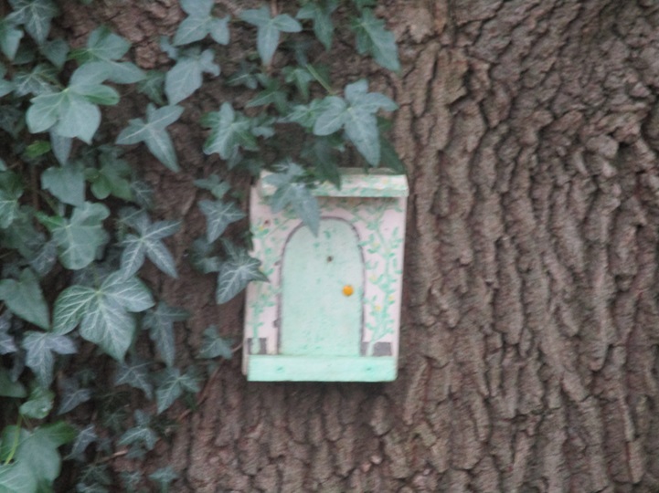
In those intervening years, fairies have visited Clay Lane too. Their tiny houses nestled at the base of trees. We were admiring many of them… and walked by a cache. After walking a few yards, we retraced our steps, and after quite a lengthy search -found the cache. Another old cache as it placed in 2008!

We returned to Buckhurst Meadows and found the last cache snugly hidden behind a lifebuoy post, again near a junction of footpaths – so stealth was needed.

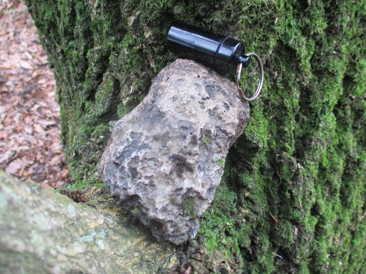
Close to Buckhurst Meadows were 2 more caches – both near the busy A329M. The first in a cul-de-sac that led to a hotel (in Mr Hg137’s time, the hotel was a nunnery!). The GPS wavered here but we soon found the tree the cache had been placed behind.

We crossed the A329 to find a most unusual cache called “It’s a Letterbox”. Letterbox caches, are named, after the ‘letterboxes’ found on Dartmoor. Geocaches of this type tend to have an ink stamp inside. The size of letterbox caches tends to be slightly larger than average, to accommodate the ink stamp, but the size of this cache caught us by surprise!

A highly unusual end, to a fun morning’s caching!

November 13 : Yateley Lakes

A new-ish series had been placed around Yateley Lakes. This is an area we have walked and cached several times. It seems a popular place for a cache owner to place a few caches, leave them in place for a couple of years and then remove them, allowing the space for other caches to be placed.

We had previously found two of the Yateley Lakes caches in 2018 and 2021, but now there were another 10 to find.

The River Blackwater runs parallel to the Lakes, and perhaps it was not a good idea to undertake a series so close to a river and lakes the day after 2/3 of an inch had fallen. Hindsight is wonderful.

Alarm bells started to ring as we drove to the car park near cache 1. Farmers’ fields were awash and the water was flowing from the fields across the road. As we approached the car park we saw a sign saying it would closed the following day, but it was padlocked shut today as well.

One of the drier road sections!

We had one other alternative, to drive back through the flooded roads, to another car park. This one was closer to cache 12.  As we approached the car park the roads were even wetter as  roadside ditches had overspilled their banks. We also noted that 3 caches we were due to find were along this flooded section.

We decided to start the route, and would abandon if the riverside paths were too submerged. We also decided to miss the caches near the flooded road section.

The caches were set by local cachers VR7, who are frequently devious in their choice of containers and hiding place. Given that Yateley Laeks is a popular area for walking, this is no bad thing – it just meant we wouldn’t have any ‘quick finds’. We also had a 5 stage ad lab to complete, though we noted a couple of the sections were closer to the flooded road, so again we decided to move these stages to a subsequent visit.

View from inside a bird hide

Surprisingly the paths around the Lakes were easy to walk around. A couple of large puddles here and there, and one very long muddy section where we had to navigate by and avoid the nearby barbed wire. Otherwise our sturdy walking boots were ideal. 

As we expected the caches were ‘devious’. Sometimes the hints were misleading – “I’m next to a Multi-Trunked Tree” was one such hint. The GPS led us to a large tree where the cache would have been placed by most other owners. VR7 had put the cache next to a much, much smaller tree about a yard away! We spend ages here as we did at several other caches.

The ad lab stages were far simpler, a quick question – sometimes involving counting, other times noting names from a memorial bench.

Lots of information boards – useful for ad lab stages

Soon we were approaching the lowered numbered caches and we saw a couple walking towards us. They had parked in the car park which we thought was locked. It was, but it is generally unlocked from 930… we were there at 920! The approach to the car park from the River Blackwater is along a footpath on one side, a hedge in the middle, and a bridleway on the other. The caches we had to find were invariably on the wrong side of the hedge, so some backtracking was needed.

We were surprised to see a birdbox close to cache 1, and assumed this to be the cache. It wasn’t and a bird flew away as we approached. We are sure many other cachers would make the same mistake, and the cache owner has changed the hint, so that the birdbox is ignored. 

Sadly the route is not totally circular –  and we headed back to cache 12 taking one diversion to cache 7 (the easiest cache of the day) situated partway between 2 lakes.

With hindsight we could have completed the series, but we had mentally said ‘park the rest for when the conditions are drier’, so we drove back, through the slightly dropping water levels back home.

Yateley Lakes – we will be back!

October 21 : Binfield (Home Turf Series)

Binfield is a small village/town, a little like Sandhurst, which is part of Bracknell. A new-ish series had been placed on the footpaths and tracks to the North of the Village. The series owner, GilDean, lives in Binfield, hence the name ‘Home Turf’. But, this was a puzzle series too.

Every cache name was an anagram of a film star, some current, some from former times. Not being film buffs, we had to work hard at each anagram as the brief film role biography was occasionally alien to us. Examples of the anagrams included BARRELED TRUG, YUMA RECALLING and MONKS HAT (Answers at the end of the blog). Having solved the anagram we then had to ascertain a key date in that person’s life, and use the digits from the date to derive coordinates. There were 21 caches in the series, so quite a lot of anagramming and googling before we even found a geocache.

Parking in Binfield is limited, so we parked in a residential street, and were greeted by… Mr Potato Head!

Apparently over the next week, Binfield would host a scarecrow competition/walking trail. Residents were invited to place a decorated scarecrow, near their property. We saw a couple of scarecrows as we left the car, several others as we approached the centre of Binfield, and also when we returned to the car much later. A lot of ingenuity and fun – well done Binfield.

As for the caching we found cache 1, quite easily, though there were several metallic places a ‘magnetic’ item could have been placed. We took a short diversion to the village centre to find our only non-‘Home-Turf cache of the day, before resuming the film star series.

Saturday morning is clearly dog walking time, and the first few caches were placed near a popular dog-walking route. Stealth was definitely needed as we retrieved magnet caches from signs. hanging bison-caches from trees, and one we never did retrieve as it was wedged behind some broken concrete. When we mentioned this to the cache owner he granted us the find, as the cache was impossible to retrieve, mainly due to the over-zealous placing by a previous finder. There was one other cache we couldn’t find, and this was due to a footpath gate being temporarily closed and access to the cache was impossible. Again the cache owner granted us a find. Thank you GilDean!

The dog-walkers became scarcer as we headed further away from the village, climbing slowly up a muddy track. Caches were placed at regular intervals and one was placed near to a seat, exactly half-way round the route. How convenient and thoughtful!

Most of the caches were quite small, but a couple of the caches were big enough for trackables, and we dropped off two, Ezra the Eagle and Polly the Parrot and found another two to replace them.

Most of the caching trail was on footpaths or tracks, but there was a short section of road, with a surprising amount of traffic. There were caches on this section too, and stepping away from the traffic to hunt for a cache behind a tree, provided welcome respite.

As we turned away from the major road, and onto a minor road, two horses went by. We were accused of startling the horses! We still don’t know why ! The minor road was close to Billingbear Polo Club and it was here a polo ball had been used as a cache container. (About a year previously we had undertaken the Oh Balls series, by the same setter, and we suspect this cache container may have been left over from that route). Mr Hg137 jumped over a ditch, collected the cache, and threw the ball to Mrs Hg137 to sign the log.

The hint for this cache had specifically stated ‘Be Stealthy and Careful’. A van was parked opposite, with its engine running but had no-one in the cab, we were in in the clear….except….just as Mr Hg137 threw the ball across the ditch, a group of 8 walkers strode round the nearby bend in the road. We nodded to the first seven of the them, giving the appearance that ditch jumping whilst holding a polo ball is a natural thing to do. But the 8th person, said ‘What are you doing here?’ It was our neighbour from home, and we were standing closer to her, than our houses are! Fortunately her walking group had now pulled away, and we never did explain about the ditch, the polo ball and the tiny sheet of paper inside.

Polo Ball Cache

Our route now took us back towards Binfield, crossing fields, and passing isolated houses. A small smattering of caches to find, as this part of the route coincides with another puzzle series and the minimum distance between caches (1/10th of a mile) was being strictly adhered to.

As we skirted round a field, we approached probably the best cache on the circuit. It required more ditch jumping by Mr Hg137 – a bit wider and far more slippery than the polo ball cache, and then a search. We were advised it should have been visible from the field-side, but we couldn’t see it. Eventually Mrs Hg137 crossed over too, and we wandered between trees, looking for the cache. Then we saw it, one of our favourite types, a ‘pulley’ cache. We had to lower some rope to lower the cache. Sign the log, and return the log to its lofty position. Easily done… we even survived the second ditch crossing too!

Pulley Cache

After a cache hide that we really enjoy, came a cache hide we really hate. In ivy. Normally ivy hides take ages, but Mr Hg137 found the cache in what for us was a record time (less than 2 minutes!).

A short walk led us back to the car, pausing to search for our last caches of the day.

A very good route, a great variety of containers, and a little brain exercise beforehand to balance the 4 mile walk in Berkshire Countryside. Thoroughly recommended. Here are a few of the standard caches we found :

PS Did you work out the film star anagrams ? Here are the answers : GERARD BUTLER, CAREY MULLIGAN, TOM HANKS.

October 1 : The Ridgeway : Wigginton to Ivinghoe Beacon

Our final day’s walk along the Ridgeway started not from home, but from the hotel we stayed in overnight. We were the first into breakfast, and had almost left the restaurant before the next guests arrived. Although the hotel was the ‘nearest’ to the end of the Ridgeway, it was still a 4-5 mile drive through Tring to a large car park. (There are actually 2 car parks near Ivinghoe Beacon – both are a good half mile from the Ridgeway end, so we would have a half-mile walk at the end of the day when the Ridgeway was complete.)

Distant view of Tring from Tring Park

We then drove our second car, back through Tring, and into the village of Wigginton. We opted for a different parking place from the previous day, which saved us partially retracing the route which we had walked in fading half-light 15 hours earlier. As we arrived at the road junction, where we left the Ridgeway previously, we noticed a parked car… we wish we had researched this spot – it would have saved us a mile’s walk! We would see that car, and its occupant twice more as the day progressed.

After a mile’s walk, we are resuming our Ridgeway walk

So, at about 945 we were back on the Ridgeway for the last time, at first a little road walking (sadly no pavement) before we entered Tring Park. Tring Park is about 265 acres of mixed habitats – including chalk grassland, parkland, landscaped views and woodland. The Ridgeway section passed through the woodland section. The estate is now manged by the Woodland Trust, but in 1872 it was bought by Lionel de Rothschild. His grandson, Walter, established Tring Park as a zoo, with giant tortoises, zebras, and cassowaries frequently being seen in the park!

The zoo, is commemorated on a beautifully carved seat, overlooking Tring. This was the site of our first cache of the day, a virtual cache, and all we had to do was count the number of carved trees and animals. Easy! No!

Sitting on the seat were a group of 6-8 girls, all clearly undertaking a Duke of Edinburgh hike. They were laughing, chatting, eating a mid-morning snack. It seemed churlish to evict them. We then remembered there was a physical cache nearby. We searched around a selection of tree roots, pausing periodically to see if the carved bench had become vacant. Eventually the girls walked away, and we scuttled over to the seat. Just as we arrived a family of 4 arrived, so we all had ‘elevenses’ together. We needed them to move for us to complete our count. How long could we eke out our coffee ?

Just as the family moved off, a group of a dozen walkers came by and wanted their group photo taken.

Minutes later, we were free of distractions and counted the various carved objects. It was only when we got home that we realised in all the confusion at the seat, we had counted the number of zebras and NOT the number of trees! Fortunately we accompanied our answers with a timed photo, so we were given the ‘find’.

Mr Hg137 on the seat, admiring the view

We left the seat – some 30 minutes after we had first approached it, and resumed our search of the nearby cache. We gave ourselves a further 5 minutes – and found it within that parameter – just! Phew!

We continued through the straight paths of Tring Park, passing another group of DofE walkers. This group were definitely less cheerful than the first, so we encouraged them with the thought of a ‘lovely bench’ for coffee, just a short way ahead. This raised their spirits considerably.

We left the wood on the outskirts of Wigginton, crossed a couple of roads, and then headed down towards the busy A41. Partway along was a puzzle cache we had solved, and as we had few caches on our route we attempted a find. At Ground Zero, there was a large tree, which most cachers would have used as the hiding place, but no, this cache was wedged into a small, rotting stump nearby. Another cache which took far too long to find!

We crossed the A41 on a pedestrian footbridge and walked a short distance between fields. and another road crossing, the surprisingly fast and dangerous A4251. A traffic island made our crossing easier. On the far side, was a parked car, the same car we saw earlier. A man was setting up a table with drinks. He was a DofE marshal for a group of Scouts and they were due shortly. We chatted about the DofE girls we had seen earlier, and he explained that most DofE exercises finish during October and everyone was trying to use every available weekend!

We walked on, through an enclosed footpath between two fields, to look for another cache. After our poor searching at the previous caches, we wanted a quick find here. We didn’t get it – and after 15 minutes peering unsuccessfully into a bush we gave up.

Another short road walk took us to the outskirts of Tring (the opposite side of Tring from where we had stayed overnight). Here the Grand Union Canal and Railway cut through the Chiltern Hills. Both the canal and railway hosted caches.

The canal cache was one we had attempted way back in 2012 on our second day’s caching. We didn’t find it then, and we almost didn’t find it again. The GPS wobbled and we never got a clear, definitive GZ. We misinterpreted the hint ‘ a couple of steps up the bank, in the ivy at the base of a multi-trunked sapling’. We assumed the ‘couple of steps’ alluded to the steps which took us down from the pavement to the canal-side towpath. Even after 11 years geocaching, we can still misinterpret a hint! The cache was further along the towpath, with a couple of steps up a muddy bank to the now more established, sapling!

Grand Union Canal – somewhere down there is a cache!

It was nearing lunchtime and we decided that stations provide more than adequate seats. As we arrived at the station we had a dilemma, go searching for a nearby cache – or have lunch on the empty seats ? We chose the seats, as they may be taken later. We watched people come and go into the station, a group of 6 Scouts walked by – we suspected they were the Dofe group the marshal had been waiting for, and stared intently at GZ. Would anyone else start looking for the cache while we watched ? Would they save us a precious few minutes ? Of course, no one came looking, and we searched and found the cache relatively quickly.

As it transpired this was our last cache on the Ridgeway, as, soon after, the Ridgeway passes through an Area of Outstanding National Beauty and a couple of Wildlife Areas where caches generally aren’t placed.

As we entered one of the Wildlife Areas, we overtook the 6 DofE scouts who had paused for lunch.

The last 2 miles of so of the Ridgeway was a steady climb, initially through light bushy woodland, giving occasional views of Tring and Tring Park. As the path rose, the woodland gave way to chalky grassland – very reminiscent of the chalky grassland we had experienced on the Ridgeway some 75 miles ago. Sheep were grazing on the grass, and several times we waited for flocks of sheep to cross the path heading for apparently better grazing.

The paths were busy, sometimes splitting, and reconverging, with lots of people heading upwards. We knew we were getting close when we saw the first of the two Ivinghoe Beacon Car Park, but then… the sting in the tail, a very steep uphill final section. The chalk path was quite eroded, slightly damp and slightly slippery, but shortly after mid-afternoon we reached the end of the Ridgeway, the Ivinghoe Beacon trig point.

We didn’t have the top to ourselves – several young families celebrated their walk from the car park, other walkers were talking in the view too. And then another group of adults, chatting.. waiting.. It was our ‘friend’ the Scout Marshal and a couple of other Scout Marshals awaiting their respective parties to arrive. We chatted with them and then descended the half-mile back to the car park, passing the Dofe Scouts on their final ascent.

Ivinghoe Beacon (and a rare photo of Mr and Mrs Hg137)

As we approached the car park, a lady carrying a couple of bags, and an expensive camera approached. ‘Is it far to the top?’ she said. We said about 20 minutes, a bit slippery, but very do-able. She explained he had been hired by a young (we assume) couple who were about to be engaged on Ivinghoe Beacon. They hadn’t told her of the distance from the car park to the top and she was concerned about being late, and the slightly fading light. Clearly the marriage proposal was not going to be spontaneous!

Back in 2012 we walked the Ridgeway for the first time and in its later stages found our first geocaches. We remembered the great views, the interesting experiences – but the weaker pavement sections, the less picturesque sections had slipped from our mind. We were certain of one thing though… the hills had definitely got steeper (and not us being 11 years older!). Here are some of the caches from our final Ridgeway section :

Thank you Ridgeway, in your 50th Birthday year – for a great walk across Southern England.

June 27 : St Ives, Cornwall

We were in Cornwall on a guided walking holiday. We had visited many of the bays, coves and villages that Cornwall is famous for, but not done any geocaching. We have tried over the years to geocache on a guided walk, but it is near-impossible  – so we now don’t try.

Our base for the week was St Ives, and on the ‘rest day’ from guided walking we set about finding some of the caches in St Ives.

We had 3 church micros (all multis), another multi based on the lifeboat station, a virtual cache where we had to email some answers to a couple of questions, a 5 stage adventure lab, an earthcache and two standard caches. We were in for quite a day!

Most of the caches were attempting were close to the seafront and we decided to start at the Eastern end (closer to our hotel) and head West. As it turned out, this was a big mistake as all but one of the muti-caches sent us in an Eastward direction retracing our steps. St Ives has many bays and beaches with the town centre about 20-30 feet higher. We descended from the hotel via some steep pavements, and some granite steps (which we would see a lot of later) and walked Eastwards to our first cache. At the far end of the town beach, the promenade zigzags up and away from the town. Having descended a lot of height from the hotel, we were disappointed we had to climb so quickly afterwards.

First cache of the day

The cache, one of only two standard caches we were to find all day, was tucked in a bush in the tight bend of a zigzag. A fairly easy find, and as we signed the log on a nearby seat  – a robin came and checked what we were doing. The cache was big enough to leave the trackable Muh-Kuh. Good luck on your future journey.

We walked back down the zigzag path, and arrived the beach promenade. We had only been about 15 minutes at the cache site, and in those 15 minutes the beach had ‘woken up’ . There was more hustle and bustle about the beachside emporia, the smell of all-day breakfasts permeated the air. Children were running to the beach.

St Ives Station brings ¾ million people a year to the town and the station was the first part of the adventure lab. All we had to do was find when the station was opened (and it was over 150 years ago!). Part 1 of the ad lab complete we returned to the set of granite steps we walked down earlier.

Can you see the sparkly granite ?

These steps link the beach to the main town centre, and were quite busy. An earthcache had been set based on the granite in the steps and surrounding walls. We had to measure granite stones, compare granularity, and explain any differences in granularity all while families were struggling down the steps with buckets, spades and other beach paraphernalia. 

How many clock faces ?

We walked on to the first of the Church Micro Multis. Like many such caches we had to count objects, write down dates to derive coordinates. One of the more interesting questions was ‘how many faces does the church clock have’. Is the answer four (a face on each side) or one ? Or neither!

We sat in a small garden of remembrance, calculated coordinates and realised we had to head East… back to the Granite Steps. We were looking for a magnetic cache. At GZ there was only one metal object – a rather smelly drippy drainpipe. We both shoved our hands up, in, and around the drainpipe to no avail. Remember this was next to the Granite Steps, where people are busily going up and down.

Then we remembered – geocaching coordinates are great in 2 dimensions, but NOT in 3. If we climbed the steps our coordinates would still be same, just higher. Here indeed there were more metallic objects, and after a few minutes the cache was found. It took us a lot longer to remove the rancid drainpipe smell from our hands.

Dotted along the seafront, are various plaques giving details of various tragedies at sea. On a hot benign day in June, it is hard to imagine – but on a wild winter’s night the sea needs a lot more respect.

St Ives Lifeboat Station – the start point for 3 geocaches!

This was evident at the Lifeboat station – where various plaques told us of previous rescues. It was here, that three geocaches collided. We had another ad lab question, a virtual cache question to answer, and some numbers to collect for another multi. It was possible to stand in one position and find all the answers. Having completed the virtual and ad lab, we calculated the coordinates for the multi. Back in the Easterly direction  – far beyond the Granite Steps we had already spent too much time at. We decided to park this cache, until the end of the day, when we were heading back to the hotel.

We were entering the tourist/working quarter of St  Ives bay.  Holidaymakers were out in force, buying coffees, ice creams. There was a constant throb of diesel engines in the bay. We were grateful we didn’t have a physical cache in this stretch, as it was very busy. It was also very busy outside the Sloop Inn where we answered another ad lab question. The Sloop Inn has a webcam, which rotates between the lifeboat station, its own serving tables, the pavement, the sea front and the town quay (Smeaton’s Quay)

St Leonards Church

Our next ad lab question was at St Leonards Chapel, at the entrance to Smeaton’s Quay. St Leonards is also known as the fisherman’s church. The ad lab question was quickly answered, as was collecting some numbers for our second church micro. Unusually for us, the final was in a westward direction so at least we didn’t have to backtrack along the busy seafront. We did though walk the length of Smeaton’s Quay, as there was a small, standard cache hidden at the far end. This took us a but too long to find, as the coordinates were a little off, and the hint didn’t  provide an obvious clue. The end of the quay was quite busy, so we ambled around, casually looking at potential hosts, as well as admiring the boats in the bay. Eventually we stumbled across the host and discovered the cache wasn’t even hidden – just lying in broad daylight. We decided to replace as per the hint.

We headed West, passing through a maze of old-town houses and cottages. This is where St Ives fishermen lived many years ago (and may do so now).

It is also the artists quarter, and many of the small shops were selling paintings, pottery and the like. St Ives had an artist’s movement in the first part of the 20th Century and today boasts the Tate St Ives gallery. On our walk around town we saw a Barbara Hepworth statue, and artists of tomorrow learning their craft.

After traversing the old town we arrived at a small cove. Above the cove, hidden in the rocks was the St Leonards Church cache. A surprisingly tricky find. We sat on the rocks and had lunch watching swimmers, and snorkellers in the bay below.

Rising beyond the bay is a small hill. Atop the hill is yet another church  – and of course its associate Church micro cache. On the way there, we found our last ‘standard cache’ of the day, well hidden on a slightly-too-steep-a-slope for comfort. One slip of the wet grass… and it needed good shoes to prevent some sliding towards the sea. It was here, as were checking our best means of approach to this cache, we saw one of our walking leaders of the week, we had a chat… and then continued our search. Well hidden, and our reward was a heart-shaped trackable.

The last Church of the Day, high on a hill

Our searching of the last church micro cache was hampered as a couple were ‘canoodling’ right next to where we wanted to search. We found a seat, had a quick coffee, and waited.. The couple had moved on, and we found the cache quite easily.  (It would have been more appropriate if the had found the heart trackable in this cache of course!).

So our westward journey was complete, all we had to do was wander back along the seafront, through the throng of tourists, passing the granite steps, heading almost back to where we found our first cache of the day, to locate the ‘Lifeboat multi’ we had parked from earlier. Hidden in a bush, behind a seat, it didn’t take too much rummaging to find.

An interesting fact… but why did they do it ?

So a great day’s caching several multis, an earth cache, a virtual, some standard caches and a 5 stage ad lab. And given the number of times we passed the Granite Steps… we know that like the back of our hand!

May 20 : The Ridgeway : Foxhill to Ashbury

We had a choice with our next section of the Ridgeway – take 2 cars and undertake a 7 mile walk with nearly 40 caches or split the distance into 2 shorter sections, with about 17-19 caches in each.

We decided to keep the distance short and number of caches to 17. (Our caching record is 34, so we knew how hard 40 would be).

Rather than take 2 cars, we opted for a there-and-back along the Ridgeway.

Foxhill Car Park was much quieter than the previous week (no charity checkpoint this week) and we were soon on our way, climbing up level with Foxhill Transmitter.

Our first cache had a good view of the transmitter, but little did we know that our approach to the cache would be indicative of most caches we were to attempt that day.

The cache was positioned about 6-10 feet from the Ridgeway and to reach it, we had to walk through 5-6 foot high nettles and cow parsley. An easy find, but a painful one!

Many of the caches we were undertaking were part of  a series named, or should that be numbered ‘the first’, ‘the second’… up to ‘the twenty third’. We had found ‘the second’ the week before, and our second cache of the day was in fact‘the ‘third’ !

Before we reached out next cache, we saw something nobody likes seeing in the countryside – fly tipping. Mainly sheets, coushions, mattresses. A few yards further on we saw a sign with a phone number to report fly tipping. We did our duty, and hopefully the rubbish would be cleared in a day or so.

As we walked on, generally upwards we collected more and more caches in the numerical series. The Ridgeway frequently gave views to the North and East, with more intermittent views to the South.

The views were not constant as periodically there were lines of trees or bushes, set 6-10 feet from the Ridgeway, with a protective line of nettles and cow parsley (and occasional thistles and hawthorn) in front. To find the caches, we had to brush through the hawthorn, the thistles, the cow parsley and nettles before we could undertake a search

Every cache we attempted became a struggle through the undergrowth – we tried to take in turns to locate a cache, so that we each had a few minutes respite from the stings.

This wasn’t always possible, as often there were a couple of hosts to search and we needed 2 pairs of eyes.

A warm Saturday in May brings lots of people to the Ridgeway. We saw lots of walkers like ourselves, several runners, many of whom were training for the ‘Race to the Stones’ a 50k (or 100k!) running event in early July.

Most of the fields were arable, but we did see some fields of pigs and nearby a van where the pig products are normally sold. Normally it would do a roaring trade on the Ridgeway on a Saturday, but the owner had another booking at a village fete, so we couldn’t sample the wares.

After about two-thirds of our route, we changed Cache owner, this time to Pebbles and Co who we met caching about 15 months ago in Fifield.

Her caches were split into two different types : letter box caches and ‘unusual’.

The letterbox caches contained in a stamp (a legacy from when geocaching perhaps emulated Dartmoor’s letterboxing). The first cache we found was called ‘two little ducks’. The stamp should have been a picture of two little ducks. Mrs Hg137 tried to use the stamp on spare piece of paper we had with us….what a disaster!

It smudged, badly. The ink from the inkpad went evey where. After a couple of minutes we both had blue hands! We decided after that to not try the stamp in the other letterbox caches.

As for the unusual caches, the container was simple but is was connected to unusual items… a mini bird box, a small skeleton, and a spider (A clever clue ‘8 feet up’…. A spider has 8 feet but it was only 5 feet up in a tree)

We had two failures on our outbound journey at ‘the seventh’ and ‘the thirteenth’. As we walked back to the car, we had another attempt at each. We failed at the thirteenth – a blue bison apparently – and found the seventh after some extensive searching – an old fish pot.

We found 16 out of 17 caches, and obtained some nettle stings in interesting places too.

May 7 : The Ridgeway : Hackpen White Horse to Ogbourne St George (Southend)

Part two of our 2023 Ridgeway walk was from Hackpen White Horse (or more correctly the car park!) to the hamlet of Southend just south of Ogbourne St George.

The day was murky, and low cloud greeted us as we set off. We didn’t have too many caches to find on our 7 mile route and the first was some distance away at Barbury Castle.

On our way to the castle we passed several walkers, including three Duke of Edinburgh groups, each with a varied level of competence.

Barbury Castle,  is an ancient hillfort dating back over 2500 years ago. It is an enormous circle surrounded by steep defensive ditches. Our path took us straight through the centre of the castle (now a grassy area). Many visitors walk above the circumference of the castle on the banks above ditches.

Our first cache was a multi, based on a noticeboard at the top of the slope near the castle entrance. Information extracted, we realised the final coordinates were back down the hill. We had a brief discussion as to whether to descend the hill, find the cache and re-climb the hill or pass the cache by. With only a handful of caches to find on our day’s walk, we opted for the extra exercise of descending and reascending the hill. We found the cache, wedged under a hawthorn bush and beside a stream was an ammo can – a great find and an old cache too – it was placed way back in 2004.

The ammo can also contained two trackables, placed there by a local caching team to us in Sandhurst, EL-JO. We took the trackables, and decided not to take them to Berkshire where EL-JO has brought them from!

Barbury Castle was quite busy, and we soon realised why. About half a mile beyond the castle is a large car park. The car park was so large there was a geocache at either end of it. (And as caches have to be 1/10 th of a mile apart this gives some indication of the car park size)

The first car park cache was exactly what a cache should be (with one notable exception).

Firstly, the reason for placing the cache. There was a great view from GZ. In fact the view was so good, there was even a toposcope telling us what we could see (or rather what we couldn’t see due to the low cloud). (As an aside, the word ‘toposcope’ neither appears in the online dictionary for this blog nor a printed version, so clearly its not called a ‘toposcope’ – wonder what it is called?)

What is this called if it is not a ‘toposcope?’

The second reason we liked the cache was the hint. Rather than ‘behind post’ or ‘behind tree’ , the hint related to the ‘toposcope’. The cache was hidden ‘in the direction of’ a place on the plaque – very clever.

Thirdly the container, Well hidden, dry and well protected.

Too well protected – as it was surrounded by stinging nettles (its only detrimental point). As Mr Hg137 has found the previous cache in hawthorn astride a ditch… Mrs Hg137 took on the stinging nettle challenge… and won!

At the far end of the car park was another cache. We went the wrong side of a fence line initially, but after a few minutes we corrected our error and quickly found the cache.

Finding this second car park cache caused us to lose our bearings a little from the Ridgeway path, and it took some time to realise the path bypassed the car park, and our caching exploits had taken us 100 yards from our intended route. Whoops!

The section of the Ridgway leading away from Barbury Castle to the village of Ogbourne St George is delightful. A gently grassy slope known as Smeathe’s Ridge. Most of the Ridgeway path we had encountered was stony and flinty and the smooth grass was a delight to walk on.

We admired the views as we descended, a point to point course to our right, horse gallops to our left. Indeed we were overtaken by a horse rider, who we saw later as she rode back up the slope.

Eventually the village of Ogbourne St George came into view and we took a detour to find the Church Micro geocache. There were 2 waypoints we had to visit, and because we were entering via the back entrance to the graveyard, we undertook the waypoints in reverse. Some dates extracted from a gravestone, then we went to the front of the churchyard, to find the remaining numbers. A lady sat on a seat near the lych gate. Her dog, Millie, growled and barked as we approached. We sidled around, found our numbers, and sidled back. All under the growling watchful gaze of Millie.

We found a seat and calculated the final coordinates – fortunately for us, back towards the Ridgeway. We stood up, and Millie had one more growling moment before we disappeared.

The cache should have been here!

Sadly our cache locating skills were remiss. The previous ‘finder’ had noted the Ground Zero was being re-fenced, and our hint item (45 degree upright) made no sense with the now vertical posts. We sent a picture of  the groundworks the cache owner, who allowed us a ‘find’ as we were clearly in the correct place, but the area has been redeveloped.

We left the church area, returned to the Ridgeway, and skirted around the village of Ogbourne St George. (The river Og flows through the village, and the church named after St George).

Most of the day’s walk had been on the high Ridgeway, but now we were at the valley floor, nearer the river and the paths were muddier. Fortunately our car was parked in the picturesque hamlet of Southend, a mile of so further on so had only a short ‘mud’ walk!

A delightful 7 mile walk – with only the paucity of caches letting it down!

March 11 : Lily Hill Park, Bracknell

Lily Hill Park is an area of 56 acres of parkland to the East of Bracknell. Formerly a Victorian house and gardens, it passed through several owners (each adding their own features), until it was taken over by Bracknell Development Corporation in 1955. It then became neglected until its restoration in the 2010s.

Mr Hg137 had visited once over 30 years ago, the park was totally new to Mrs Hg137.

What a jewel the park is ! There are many features to admire as you wander around including a ha-ha, an amphitheatre, an Edwardian water garden and a kissing seat.

We had 4 caches to find – two from the counting vowels multi-cache series, a 5 part adventure lab and its bonus, as well as one other cache just outside the park.

We have discovered over the years we get very confused if we are undertaking more than one multi/ad lab at the same time. So to prevent confusion, and to minimise a lot of backtracking, we printed a map and annotated all the waypoint stages. We could walk around with GPS in one hand for the Counting Vowel caches, and a phone for the ad lab cache and just remember which stage was our next destination! It worked well.

The counting vowels waypoints took us, as expected, to many signs, where we wrote down words and counted vowels. The words varied from Latin plant names to words on information boards – and there were many of those!

The ad lab sections were more visual. We had to count the chimneys on the old Lily Hill Park building, (not easy as many of the chimneys blocked the view of others), a couple of fallen trees now made into a major features which we had to explore, as well as a Story Telling Throne which is great for clambering on. (A young child was doing this when we took photos, so we have not included a photo it).

Our first cache find was the first of the Counting Vowels.  The cache owner gives very specific hints and we knew we were in the correct place, but it took several minutes of searching . We were inhibited by a large holly tree, which prevented easy access, and it took us three attempts to locate the cache from the roots of a tree.

Partway round we left the park to find a cache in the ‘Milestone’ series. This was a first for us, as we didn’t know such a series existed. The cache we found was 130 in the series.

The premise of the series is that the caches are near to a milestone. It took us longer to cross the busy A329 than it did to find the cache.

Back to the park and we were half way round the ad lab. We paused at ‘Britain’s longest picnic table’ cut from a single piece of wood. The current table replaces a previous one installed back in 2010.

The Western half of the Lily Hill Park has more interesting features, but our trails took us into the Eastern half. The paths were windier, and there were less people. We paused in the ‘Summer House’ to calculate the final position for our ad lab cache. As we did so, the grassland nearby suddenly filled up with dachshund owners and their dogs! The photo doesn’t do it justice!

Our navigation to the ad lab final cache and the second counting vowels cache could be described, at best, as ‘poor’. The winding paths did the GPS no favours and were ended up bushwhacking through undergrowth for our finds – whoops!  

The geocaches gave us a chance to explore thoroughly somewhere new, and on a early Spring morning, a delight to walk around.

January 13 : Swinley Forest

Swinley Forest is an area of woodland to the South and East of Bracknell.

Today’s caching trip was in a ‘diamond’ shape bounded by 4 major roads (The A329 to the North, the A332 to the East, the A322 to the South and the B3430 to the West).

Our main aim was to visit 4 standard caches broadly close to each of those roads (and appropriately named North, East, South and West). We had solved a couple of puzzle caches which we hoped to find on route, as well as another cache in the centre of the forest diamond.

One of the puzzle caches we had solved was a simple picture identification task once the cache title ‘nice tours, erotic sun’ had been interpreted. The other was more obscurely titled ’30 / 7’. Within the puzzle we had to ascribe numbers to simple words like ‘PANS’, and ‘DANCE’. Once inspiration struck, the puzzle was quickly solved.

One of the puzzle caches was hidden in a holly tree. Deep in a holly tree. There were several at GZ, but one large specimen stood out. We circled it several times, peering into it to no avail. We decided the best way to locate the cache was to scramble into the tree, through lots of prickly leaves and look outwards. Mrs Hg137 volunteered (!), while Mr Hg137 re-read previous finder’s logs. One of the logs made mention of the many dog walkers, which indeed there were, but to find the cache, one had to ‘stand where you cant see the dog walkers’. Mr Hg137 sidled around the tree, hiding himself more and more from the footpath. He looked in… and found the cache. It was easier, just, for Mrs Hg137 to be directed to it..before she left the tree incurring a few more scratches.

Our second puzzle cache find, was in a much quieter location and trusting the GPS implicitly, Mrs Hg137 found the cache in an instant, and in a far less prickly place.

The Northernmost part of our route

Then onto the Compass Series.. North was nearby and we managed to find the cache and leave GZ before a dog walker came by. We even found a trackable too called Travel Toad.

To reach East, we had to cross the centre of the diamond passing another cache ‘Mr Jennison’s Fridge’. An intriguing title .It referred to the ice house of a former grand house in the forest. The cache description provides the following information :

The cache is placed very close to the site of an old ice house belonging to Swinley Lodge. Until the 1820’s (when it was demolished) this was the official residence of the Master of the Royal Buckhounds. It was the location for the monarch and his entourage to meet for breakfast when they were hunting in this area of the forest.

During the reign of George II the hunt’s master was a Mr Jennison. He was a thorough representative of the conviviality of the age, a “five bottle man” who would not allow his friends to walk away from the table.

The ice house was a deep, brick lined pit, surrounded by a circle of trees. In its shady depth food was kept fresh for as long as possible.

Part of a semi-circular entrance to Swinley Lodge

Sadly for us, the ice house has long gone and the cache seems to have disappeared too. After much searching we logged a Did Not Find. Always disappointing to log a DNF, but as there had been a couple of DNFs by other cachers in the weeks before our visit, not unexpected.

Up to now the paths had been dry, sandy heathland paths, but on our way to East the paths got muddier and muddier. Drainage ditches ran parallel to the paths, and we spent some time picking our way between less muddy sections.

East was quite cunningly hidden (well in Mr Hg137’s eyes). In the bole of a tree. A small bole. Mr Hg137 removed the ‘tiny barkoflage’ and found nothing. It was the only tree of note, so Mrs Hg137 had a feel. She discovered the bole had a kink in it, and the cache was hidden beyond the kink. Very clever!

The day was cold, and we were now at the furthest point from our car, with two caches still to find. South’s hint was ‘stickoflage’ and the GPS resolutely pointed to one particular tree  – sadly for us, we couldn’t find the stickoflage or the cache. We did note though the cache had not been found since November, and since then there had been a substantial leafdrop covering the ground. Perhaps after a few more weeks the stickoflage will be visible, but for us, our second DNF of the day.

So we headed another back to our car passing West as we did so. Unlike the other caches, this was clearly visible, but protected by a large tree. It was only as we peered through the lower branches could we see the cache at ground level. An easy find, and another trackable too (The Tourist).

So 5 caches found of 7, but more importantly a great walk in a part of Swinley Forest we have barely explored.

December 20 : Green Hill (Bracknell)

We try to geocache in different areas, walk different paths, see different views.

Occasionally though, we find ourselves walking the same paths. Especially if a path contains geocaches.

Today’s trip around Green Hill achieved an unusual accolade – we would be walking the paths for a third time, and finding a third set of different caches!

It was a December lunchtime, when we received a Christmas card that we felt we ought to reciprocate. But with Christmas fast looming, we decided to head out, card in one hand, and GPS in the other.

We have walked and cached Green Hill on the Bracknell / Ascot borders twice (July 2017 and July 2019). The paths surround, we assume, an old – now filled in – rubbish dump. High fences surround a rectangular piece of land, with monitoring vents at regular intervals. Paths and trees surround the fence.

The two previous times we had cached in this area, the paths had been set by a caching team called JJEF. They specialise in ‘wooden puzzle’ type caches. Sadly they have stepped away from the the caching scene, and many of their caching routes are being reused. As indeed this one was. The cache owner this time was GilDean, who have met on a couple of occasions.

The first cache in this new series was called ‘Resurrected’. And it was indeed a resurrection of an old JJEF cache. We didn’t remember it all – made of wood in JJEF’s style – and after a few minutes of twisting and turning the cache we were able to sign the log.

The paths around the Green Hill are linear, so we had an out and back route. This is quite useful when geocaching, as it gives two opportunities to find a cache especially if the paths are busy. This footpath wasn’t and we didn’t see a soul all afternoon. We walked around Green Hill, pointing at trees, trying to remember…was there a JJEF cache ? Or was it…that tree ?

Cache 2 in this series was attached to a metal fence. Hidden in part by the last remaining leaves of the year, it was quite tricky to remove from the fence, as the bright, low winter sunshine was directly in Hg137’s eyes as he undid the cache.

Previous hides on this route strayed some distance from the footpaths and the fence line, but GilDean hid their caches with only a small step away from each. Cache three – ‘hidden in ivy’ – we groaned. There aren’t many geocachers that love an ivy hide, and we are no different. Fortunately the ivy wasn’t that thick, and we found the cache after only a couple of minutes.

The end of the path hosts the final cache in the series, a cleverly placed cache. Mrs Hg137 walked right by it, as she bent underneath some thick branches, and it was after a few minutes that we realised we didn’t need to go under the branches.

So our third time of caching this route was successful – we wonder if we will be back in 2 years time to find a fourth set of geocaches!

Three of the caches we found :