November 26 : Eversley

We have geocached twice before in Eversley. The first time was during April 2021, when we met another cacher Mikes54. He was out and and about undertaking preliminary work on some new caches he was about to set. We were reminded of these caches when we saw Mikes54 on the ‘Balls’ round (November 19 posting).

Eversley Church

So we headed to Eversley to undertake five caches.

Three of the caches were Counting Vowels multicaches, where we had to visit various waypoints, find a sign, and write down a word or two. Then once we had all the words, we could count each vowel and use the numbers in an equation.

The first Counting Vowels waypoint was at a field boundary, but the second was adjacent to a cache we had DNFed back in April 2021. The cache was hidden in or near a bridge. The bridge led to someone’s back garden, and our reticence to explore on the owner’s side of the bridge last time was why we couldn’t find the cache. This time we came armed with information from Mikes54.

Somewhere on this bridge is a cache

He told us where the cache was (the fact we didn’t quite remember what he exactly told us, is irrelevant) . The bridge seemed to be in a poorer state of repair than we remembered. The iron was rusting, holes were appearing in the bridge, and it looked decidedly unsafe. Mr Hg137 tentatively walked across, and then stood and searched the bridge. The rusty bridge caught his finger, so as he searched he nursed a cut. After changing position so that he was astride the stream, the cache was found, thrown to Mrs Hg137 for signing, before replacing. A tentative walk back over the bridge and we resumed our walk ‘counting vowels’.

We walked along the path arriving at a seat. We now had all the words, and hence vowels, and we quickly did our calculation. (By this time Mr Hg137, had a facemask, bandaged around his cut finger). We walked across a play area to the cache, as we blundered our way across some low lying brambles, Mrs Hg137 realised she didn’t have her geopole. Whoops! Where did she leave it ?

It was decided she would retrace her steps, while Mr Hg137 looked for (and found!) the cache. As he left the cache site, and was walking back through the play area, he met Mrs Hg137 returning. The geopole  was by the ‘bridge cache’ – Mrs Hg137 had put the pole down to receive the ‘thrown cache’!

A big sigh of relief. We were still chattering away as we arrived back at the bridge cache. This time the owner was peering over the fence, just as we were taking a picture of the bridge. Had he seen us last time ? Did he know there was a cache in his bridge ? We made polite conversation and established he doesn’t use the bridge anymore, as it is so rickety and dangerous. Mmm  – maybe he doesn’t know about the cache,

Our next set of caches were at Eversley Church, about half a mile away. We crossed a couple of fields, and were watched by several horses. Some inquisitive, some taking the attitude ‘I know you are there, but I’m going to ignore you’.

“Hello… do you have any food?”

The church was one of the few recommended parking slots for the walk. We were grateful we had opted not to us it, as the car park was full. A couple of horseboxes had parked up, as well as twenty or so cars.

We soon discovered why – it was the Church’s annual clean up. There was gardening work going on the graveyard, there was a myriad of people inside – cleaning, tidying and polishing (the smell of polish was incredible). Decorations were going  up for Advent, and there was a wedding due in the afternoon. Busy, busy busy – we didn’t linger long inside.We were though told about Charles Kingsley’s grave. Charles Kingsley was the author of “The Water Babies” and had been the rector of the church from 1844.

Charles Kingsley’s Grave

Conveniently the grave was next to one of the many waypoints we needed for our next Counting Vowels cache. We quickly collected the vowels and strode away from the church and shortly afterwards arrived in quieter countryside to search for a geocache. A quick find later and we returned to the church to find a standard cache opposite the lych gate (part of the Church Micro series of geocaches). This cache took a bit of careful choreography to find, as the churchyard gardening work was close by – every time the ‘gardener’ bent below the wall, we bent down and searched !

Read the sign…carefully!

Our final cache of the day, was another counting vowels. This time we were led down a partially-tarmacked road, and we collected out names from various objects along the way. This should have been a quiet road, but we stopped on at least three occasions to let a car, a cyclist and a horse rider go by.

A quiet road ….

Having collected the vowels, and found the cache, we returned to the church on our way back to the car.

A man stood overlooking the gate, near to where we had found an earlier cache. Was he a cacher ? No he wasn’t.

He had in his hand a satellite image of the graveyard, and he was marking on that image, where the various War Graves were. We assumed the War Graves Commission would have the exact location of each grave, but they only list the graves in the general graveyard, not an exact location. The man we chatted to, had about 5 or 6 graves to find and mark, so we left him to his work as we completed our work celebrating 5 found caches out of 5.

Here are a couple of the caches we found :

June 25 : : Kennet and Avon Canal : Great Bedwyn to Wootton Rivers – and Crofton

Hello, Mrs Hg137 here.

After a break of four weeks, we returned to our walk along the Kennet and Avon canal.   Our original plan was to walk to Pewsey, but we’d found that today was a “steaming” day at Crofton, so we decided on a shorter walk to Wootton Rivers, plus a visit to the beam engines.

We set off from Great Bedwyn.   Even though there was a rail strike, and NO trains, there was one man waiting forlornly on the platform for a train.   He said he’d checked the website … we didn’t see a single train all day … he might have had a very long wait.

Just before reaching the towpath, we stopped to find a geocache, called ‘What is a Brail anyway?’   (FYI it seems to be an area of woodland as there are two woods called ‘brails’ nearby.)    That done, we set off along the towpath, stopping to look for another four caches as we went (finding three); each of these caches took us away from the canal and onto paths or tracks leading into the countryside – which was very pretty indeed.  Summer had advanced since we were here last, and the vegetation has grown – a lot.   

After a walk of about a mile and three-quarters along the towpath – further for us with all those diversions – we’d reached Crofton.   Across the canal was Crofton Pumping Station, with a gentle wisp of smoke coming from the chimney, and behind us was Wilton Water, not a lake but a long, thin reservoir, the source of water for the pumping station.   Sadly, the canal-side gate to the pumping station is closed (Covid?), the only way in is to go further on and to walk back along the road.

Once there, we had a jolly good look round, climbed the stairs, questioned the volunteers, watched the boilers being stoked, the engines starting, stopping, pumping, and took loads and loads of photos.   After 90 minutes or so, we emerged, and ate our picnic lunch on the seats overlooking the canal, reservoir, and railway line – no, we didn’t see a single train!

Returning to the canal, we had a cache to find, ‘Crofton Beam Engines (Wilts)’ – we’d questioned the volunteers and had all the information we needed.  We worked out some plausible coordinate, passed items that others had mentioned in their logs, and arrived at a place that just ‘had’ to be the location. But we simply couldn’t find the cache, though we looked all around and widened our search too.   What a shame, we’d really wanted to find that one, it tied in with our walk.

We walked on up the remainder of the Crofton lock flight.   We passed bridge number 100; Mr Hg137 felt this to be a milestone moment, got excited, and took a photo.   At the top lock, we’d reached the summit level of the canal.   Water from the pumping station is released here and is used to supply the canal which descends on both sides.  The water arrives at the canal via an insignificant looking inlet just above the top lock. 

Bridge 100
Bridge 100

We were told that the pumping station can supply enough water to fill a lock in 15 minutes (electric pumps are used when the steam engines aren’t working).   We didn’t see many boats (and no trains at all), but it must be quite a task to keep the water level topped up.    FYI: at the time of writing, there are opening restrictions on the locks on either side of the summit because there isn’t enough water, the locks are only available for use between 08:30 and 16:30 each day.   Mr Hg137 asked how the locks could be closed:  I’ve seen it done in the past simply by fixing the lock gates shut with a padlock and chain.

For the next two and a quarter miles we walked along the lockless (and cacheless) summit level, gradually descending into a deep cutting.    About a quarter of a mile of the canal is underground, inside Bruce Tunnel, the only tunnel on the canal.   It was very quiet indeed – no boats, cars or people (and definitely no trains).    We climbed up a track and walked across the top of the tunnel.   And then we started to meet people, in groups: specifically, groups of 6-8 teenagers carrying maps and enormous rucksacks.   It wasn’t so quiet anymore.  Aha – DofE participants!   

Emerging from the cutting and a mile or so further on, we reached the Wootton Rivers flight of locks, where the waterway starts its descent towards Bath.    At the bottom of the flight of four locks we reached the road where our geocar was parked, close to the former lock-keeper’s cottage.   Those with a (very) long memory may remember it as the main location for the BBC series “The River” back in the 1980s.

Wootton Rivers
Wootton Rivers

We found our final cache of the day here, making seven caches found out of nine attempted.   We’ve been surprised that there aren’t more caches in the area, since it’s lovely countryside, well served by footpaths, interesting locations, hidey-holes a-plenty.   It would be a great place for a geocache series (or two, or three).   If only we lived closer – we could place some caches here ourselves!

PS We wonder how long that lone traveller waited for a non-existent train? There were NO trains!

And here are some of the not-so-many caches we found:

June 6 : Skipton and Gargrave

Hello, Mrs Hg137 here.

Today was our ‘day off’, part way through a walking holiday based near Malham at Newfield Hall.    Geocaching doesn’t mix well with being on a guided walk (it holds everyone up when we disappear into bushes!) so we reserved our geocaching for the day when we didn’t have a walk planned for us.

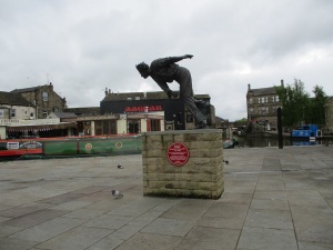
Off we went to Skipton, about six miles away.   It had been a while since we visited, so we had a look round, wandered up the wide High Street to Skipton Castle, visited the market, and reacquainted ourselves.  We also fancied a boat trip on the canal, so took ourselves off to sit canalside and watch the boats go by while we waited for the first trip of the day at 10:30. And, while doing this, we espied the statue of Fiery Fred Trueman and thought ‘aha, there’s a cache hereabouts’!   So we worked out some coordinates, and tootled off to a place not so far away (22 yards?  Not quite, but not so far off!) where we soon found the cache.  (FYI: Fred Trueman lived in the nearby village of Flasby and is buried at Bolton Priory, also close by.)

Fred Trueman statue
Fred Trueman statue

Narrowboat ‘Leo’ was now ready for the first boat trip of the day and we spent 40 minutes or so getting an entirely different view of Skipton on a beautiful, quiet, smooth trip along the Leeds and Liverpool canal, then a short trip along the Springs Branch which runs behind the castle.  It’s a different, calmer view of the world from the water …

Having seen Skipton, we moved on to Gargrave.  We had both visited the village a couple of days before, but were part way through a day’s walk and didn’t have time to stop and look for caches.   Today was different.   We started off with a cache near the Village Hall, then crossed the River Aire and walked up to St Andrews Church.  A Church Micro cache starts here; we spent a little while hunting for the waypoints. They are all there, somewhere, but the grass has been (deliberately) allowed to grow in places and that made some things hard to spot.  We ate our picnic lunch in the sunshine while assembling the coordinates.

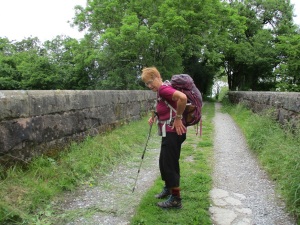
We spent the afternoon wandering around part of the ‘Gargrave South’ geocache series, which heads south-west out of Gargrave along the Pennine Way, then returns along the Leeds and Liverpool canal.    We ascended gently out of the village, finding caches as we went, and crossing over the railway line that leads from Skipton, to Settle, then on to Carlisle.   As we crossed the railway bridge, a lady came walking towards us, wearing walking boots, carrying a large rucksack.  We asked her if she was walking the Pennine Way.   She replied that, no, she was walking from Lands End to John O’Groats (LeJog), doing 18 miles a day, with no rest days, and was about 41 days into an 83 day walk.   Eek!  That is serious walking and put the paltry amount we had been walking daily – 9 to 14 miles – to shame.  Good luck Rachel Douglas from New Zealand, and ‘may the road rise up to meet you’!

LeJog - Rachel Douglas (New Zealand)
LeJog – Rachel Douglas (New Zealand)

After a few miles, and a few caches, we made our way down to the Leeds and Liverpool canal, reaching the towpath by the locks at Bank Newton.   We walked back towards Gargrave, along the most northerly section of the whole canal.   There were a fair few boats, slowly working their way up the locks; there are 91 locks on the 127 miles of the canal, so they get lots of practice!  

Twelve out of thirteen caches from the ‘Gargrave South’ series later, plus six locks, an aqueduct, and several bridges (foot, road, and rail), we were back at our start point.  But first … there was a very new cache hidden close to our geocar.   It would be churlish not to look for it.   The only snag – it was called ‘Across the Beck’ and that was exactly where it was.  Mr Hg137 climbed down and teetered around on stones in the beck while clutching a handy piece of rope, dangling from a tree.  Miraculously, he didn’t get wet … but he didn’t find the cache. Never mind: we’d had a grand day out in and around the edge of the Yorkshire Dales.

And here are a very few of the caches we found:

May 21 : Kennet and Avon Canal : Kintbury to Hungerford

Hello, Mrs Hg137 here.

Just a short section of canal for us today, three miles or so from Kintbury to Hungerford.  That would leave time for a walk around Hungerford afterwards.

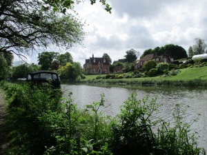
Leaving Kintbury station, we were on the towpath and walking almost immediately.  Some very impressive houses and gardens, including the very large vicarage, overlooked the canal.   While admiring the gardens, we crossed a small footbridge along the path – almost unnoticed, the River Kennet diverged from the canal for the final time – we were onto the canal proper.

Kintbury Vicarage
Kintbury Vicarage

The towpath here was grassy, and much softer underfoot than the gravelled/metalled path we had mostly walked so far.   A little further on, a horse in harness was standing on the towpath; we assumed it was connected with the horse-drawn boat company based in Kintbury.   But no, this horse once drew a gipsy caravan, owned by a lady who now lived on a canal boat, and the horse was to start a second career as a boat horse.

It was about a mile between Kintbury Lock and the next lock, Brunsden (or Brunsdon) Lock.   We hoped to find our first cache of the day here, a very old cache, placed in 2004.   It wasn’t immediately obvious where it was, and there was much furtling around in bushes before one of us emerged, not too badly nettle-stung, clutching an ammo can.   The container is a bit worn, the hinge was broken, the inside damp, and the logbook black and mouldy.  We left a sheet of paper to act as a new logbook.

Our next part of the walk continued along the canal, past Wire Lock and went looking for the three caches in the ‘Brown’s Kintbury K&A’ series.    After varying amounts of searching, we found two : one, we spotted from afar, one had an average amount of looking, and one we simply couldn’t find : we searched up and down over around 25 paces (50 feet) of hedgerow, without success, watched throughout by three muggles and two short-haired German Pointer dogs.   After a bit, we did explain what we were doing, lest we seemed a bit … odd … later on, we met them again, and gave them a little talk on geocaching, lest they still thought we were … odd.

By now, we’d reached Dunham Lock.   A wide-beam canal boat was passing downhill through the lock, with two life-jacketed ladies, of a certain age, operating the gates.  We asked if they were OK, and they replied that they were fine, just waiting for the boat to turn round.   We walked on a little way, found a seat, and ate our picnic lunch.   The two life-jacketed ladies were still there, leaning on the lock gates.   That boat had been turning round for a long time … Mr Hg137 conjectured that they were beginners and that the boat was stuck somewhere.   Umm, wrong.  The boat returned after a little while and passed us.  It was the Rose of Hungerford trip boat, full of passengers.  Just as well we didn’t go and give benefit of our ‘knowledge’ as those ladies were the crew, who knew much better than us what they were doing!

Our final few yards along the towpath brought us to a footbridge over the canal – we’d reached Hungerford.  Had we only known, we would be back on that final stretch of towpath twice more, to collect two caches; if only we had known, we would have assembled all the coordinates first and done them in one go!

Time for some sightseeing (and caching) in Hungerford.  One main road, the High Street, leads uphill away from the valley where the A4 road, the canal, and the railway all run roughly parallel, east to west.  The town centre is full of old buildings, many of them listed, and it’s a pleasant , bustling place to be.

Our ‘town trail’ took us to the bridge over the River Dun, back over the canal on the Diamond Jubilee footbridge by the canal wharf.   And back along that final stretch of towpath, to collect a cache. We then walked up the High Street, with its selection of independent shops, pubs, and antique shops (which often appear on Bargain Hunt on TV), and continued almost to the edge of town.    As we walked, we found geocaches (or saved the coordinates to visit later on).    Among them, we found three Church Micro caches in a row – it seems that the population of Hungerford spend their time in church when they are not eating, drinking, or buying antiques!   

Reaching the top of the hill, we wandered back down to look for the Sidetracked cache near the station (and our geocar, parked in the station car park).   It took us some while to find (and a good few trains passed by) because we simply didn’t understand the hint.   ‘Googie Withers’???   How does that help???   Anyway, we found the cache by sheer persistence and did some research later to understand the hint (we get it now). Then there was just one more cache to find.   Yes, it was back along that final section of towpath for a third time!

April 9 : Kennet and Avon Canal : Kennet mouth to Theale
Hello, Mrs Hg137 here.

Today was the start of our onslaught on the Kennet & Avon Canal, a project that has been on hold for two years.  Finally, there was no lockdown, and spring was here, drying out potentially muddy or flooded waterside paths.  We planned to walk from the mouth of the Kennet, where it meets the Thames, along the length of the waterway, then on to Bristol at the far end.   But we weren’t planning to do it all in one go, today’s section was to be from Thames Valley Park, through Reading and on to Sheffield Bottom Lock at Theale.

As geocachers, of course we also intended to find geocaches along our route.   We had a picnic lunch, a map of the geocaches along our route, our GPS, and a well-used copy of Nicolson’s Guide to the Waterways (South), 1987 edition.   FYI, it’s mine, and the used condition is because it spent a long time out with me, walking the canals back in the day.   I reasoned that, though the book pre-dated the complete restoration of the canal in 1990, the route would be much the same, and both canal and towpath would be in better condition than back then.

Starting at Thames Valley Park, on the eastern edge of Reading, we followed the Thames a short way upstream to reach the mouth of the Kennet.  There’s a cache close to here, and we wanted to find it to ‘mark the start’.   It took us a while, as we got the coordinates wrong and made several fruitless attempts to go to the wrong place before we realised that something was not right. We re-did the sums and came out with a better location that was reachable on foot. Off we went and found the cache at the appointed place. Finally, a cache to set us on our way, and a glorious spring day on which to do it.

The sign said ‘Kennet and Avon Waterway’. A mile upstream, past Blake’s Lock, another sign said ‘Kennet and Avon Canal’.   The bottom mile of the river, which has been a navigation since well before the canal was built, is managed as part of the Thames and the canal proper starts in the middle of Reading.   There’s a good, wide path all the way to the centre of town (only one cache, but never mind) and the waterway is lined with smart new apartment blocks and the occasional sculpture.   It’s all very neat and tidy – I walked along here before, back in the early ‘90s and it was much edgier and down at heel then.  

Reading Piece 1982 - Peter Sainty
Reading Piece 1982 – Peter Sainty

Suddenly we were right in the centre of Reading, at the Oracle, where the riverside is lined with restaurants and there is often a beach bar in summer.

Almost as suddenly, we were away from the centre and walking beside the river by County Lock, the first lock on the canal.  The shops and restaurants turned to houses, with gardens backing onto the river, and we were surrounded by greenery, not concrete.   There was still an impressive range of graffiti, though!  Almost the whole of the Kennet and Avon is part of National Cycle route 4 which runs from London to Fishguard, so both the main route and any connecting cycle paths are very well signed.      

We turned south, then west under the A33 and out into the country, with more caches to find ahead on the route.  For almost all of the rest of our route we would be following the ‘Holybrook Hounds’ series (named after a favourite walk for some local beagles), a range of 12 caches located beside or close to our route.   The first two we found were in, on, or around some of those many signs, then we crossed the canal at Fobney Lock and took a little caching diversion around the nature reserve.

It was a bright spring day, which got steadily warmer.   I was sweating in my thin jumper and waterproof jacket – I might have overdressed, as the previous week there had been snow showers, and I had worn a woolly hat, scarf, gloves, thick jumper and jacket and was still cold!  The weather changes so quickly in spring.

We carried on along the path, stopping every so often to find a cache.   There were a variety of containers, some ‘ordinary’ tins and containers, some fake bolts, and some miscelleneous fake critters.    We weren’t alone; a steady stream of people were walking or cycling towards us, approaching Reading; the clue was that many were wearing blue and white shirts; aha, Reading FC were playing at home!   (FYI, they lost 1-2 to Cardiff City.)

In gaps between passing football supporters, we found caches hidden in trees, in and around locks, behind signs, and by one of the footbridges that cross the canal.   For one cache we were ‘helped’ by an inquisitive young swan, one of last years cygnets (though full adult size, it wasn’t yet completely white and it still had the grey beak of a cygnet, not the orange beak of an adult).   Later on, we were examining a fallen tree, looking for a cache, when we were hailed by a boat-dweller opposite … “it’s in the top of that thing over there”… we’d been spotted! But he was right, it’s there!

Canal and river intertwined: sometimes we were walking along a field edge, by what seemed like a natural river, sometimes along a track by a clearly man-made cut.   Pillboxes hulked beside the water at intervals – we’ve seen this on the Thames, too, the water forms an easily defensible line.

The modern world intruded – briefly – when we walked underneath the M4.  We were nearing the end of this section of our walk and had one more cache to locate; we found it after a painful search in the fast-growing nettles, then turned our attention back to the canal.   Just afterwards, we reached Garston Lock, one of the two remaining turf-sided locks on the canal.   It’s a listed structure, as are both of the two pillboxes defending the lock.  Wasn’t one pillbox enough?    

Garston Lock and pillbox

And, after that, there was one more lock, and we had arrived at the end of the day’s walk at the car park next to Sheffield Bottom Lock.   Great walk, great spring day, and a great start to our quest.   

Here are just a few of the many caches we found:

April 2 : Bentley

Bentley is a small town, or perhaps a large village, a few miles South West of Farnham, just inside the Hampshire border.

Winter was having a final throw of cold weather, and the morning was cold. We could keep warm by walking around, but too much dawdling at a cache, and the cold weather could be felt.

We parked near the village pond and sports field, where some football training for young children was about to start. There was much running around and chasing of footballs.

The Village Pond, Bentley

There was a cache nearby, but we left it – hopefully the sports field would be quieter later, and it gave a waypoint for the car.

The A31 skirts Bentley and one assumes many years ago the road went through the village. Today the A31 is about ½ mile to the South and the village is quiet.

Our first cache though was by the A31. Or at least should have been. The cache was missing. In fairness, we thought it was missing, as the last two cachers hadn’t found it either, but they only had 10 geocaching finds between them so there was a chance they may not have looked everywhere. They had. We did as well . The cache was missing.

We headed back to the centre of Bentley and admired the village history on a large map. Various dates and numbers on the map were needed for the multi – part of the national village hall series of geocaches. A quick calculation later and a short walk and we were at GZ. A very inauspicious sign to check, but Mrs Hg137 found the cache within seconds. As we walked to the cache we noticed the town had a good range of shops – the independent grocers being the most popular- two pubs and a small trading estate.

The caches in Bentley are quite spread out, and we had long uphill walk to our next cache at St Mary’s Church, part of the Church Micro series of caches, Many of the Church Micro caches are multis, this though was a standard cache hanging in a tree. There were of course several trees, and lots of ‘protective branches’ so it was quite a tricky find.

St Mary’s Church, Bentley

We looked inside the church and sat outside for a quick cup of coffee. As we did so, several people came by – they were heading to a choir practice for the village’s jubilee celebrations. Apparently the choir will  be singing a song from every decade of the Queen’s reign, We hope it goes well for them.

Our next three caches were to the North-East of the village, and another long-ish walk.

The first cache, called ‘horses and hawthorns’, had been DNFed recently by a very experienced cacher. We decided to give this cache a quick 5 minutes, but we only needed 5 seconds ! The cache was hidden exactly as hinted, and less than 3 feet from the gps. ! How the previous cacher couldn’t find it, we will never know.

Smugly we continued on, walking around various field boundaries, crossing stiles, admiring the colourful rapeseed crop (surely it’s too early in April, for rape to flower? ), and also rows and rows of grapevines. The chalky soil and south facing slopes should be ideal for grape growing.

Eventually we arrived a large fallen tree (the cache description called it log), and after battling with the early Spring hedgerow growth, we found the large cache quite easily. More fields, and more stiles and we arrived at our next cache. ‘Troll 2’. Yes, it was hidden under a bridge.

A dried up streambed leading to the Troll’s cache hiding place!

Surprisingly it took us some time to see the bridge! The bridge crossed a stream, but surprisingly, for early April, it was dried up and a much simpler footpath, crossed the streambed. As we crossed the streambed we saw the bridge, and walked on the bank to it. The cache was supposed to have been hidden under the ‘West’ side, but it wasn’t there ! Mrs Hg137 retraced her steps, and walked along the streambed, looking upwards. There she saw the cache…. on the East side ! (In fairness there was a good ‘ledge’ for the cache on the East side, but it meant the hint was wrong!).

Our last cache was back near the car. We retraced our steps through the village, much quieter than when we walked through earlier. The playground was quiet too, as was the village pond. Nearby was the cache, we signed the log, and read various signs about the correct food for ducks. Who knew you shouldn’t feed ducks bread, but feed them porridge instead!?

The porridge sign reminded us how cold we were, so we drove home, encountering  a snow shower on the way back. 

A cold morning’s cache with some unexpected finds in Bentley.

March 26 : Effingham and the Lovelace Bridges

Hello, Mrs Hg137 here.

Lovelace Bridge: Stoney Dene

Effingham: a place I’ve never really visited, except when, a few years ago, I mistakenly caught the stopping train to Guildford, not the express, and one of the many, many stations it stopped at was Effingham Junction.   Today, we were there for the ‘Off The Rails!’ geocache series, which starts at the station.  It’s quite a long series, so we had decided to do just the southern part of the series, leaving the rest for another day.

We parked within sight of our first cache, at a post box (a passing lady on horseback asked if we were posting a letter … mmm … not really!), and headed uphill into the woods, where we stopped to explain geocaching to a friendly American man, out with Bella, his beautifully behaved retriever.   Reaching the remains of some gates, we followed an impressive brick and flint wall, the outer edge of the Horsley Towers estate.   We followed the wall downhill to reach and cross the busy A426 by one of the estate lodges.   We met yet more people: cyclists, walkers, runners, more horse riders, and even more dog walkers.   Everyone, like us, was making the most of a warm spring day.

The countryside turned to a mixture of fields and woods, and we began to climb again.   We came to a bridge … umm, a bridge??? why??? … in the middle of nowhere and with no obvious reason for its presence. There was a plaque by the bridge, and we did some research later.  An (optional) history paragraph follows:

Meadow Plat bridge
Meadow Plat bridge

The bridge is one of the Lovelace Bridges,  a series built by the owner of Horsley Towers, Lord Lovelace.  He had tracks and bridges built to help with the transportation of timber.  Fifteen bridges were built, all named, all of different sizes and designs, and ten survive.   They resemble a disused small-gauge railway – except there were never any tracks and the gradients are too steep for trains.   We saw two of the bridges, plus the site of one other, and there is a trail which does a circular tour of many of the sites. (As a footnote, Lord Lovelace’s wife, Ada, Lady Lovelace is considerably more well-known than him!)

We continued through fields, tracks and woods, which will be filled with bluebells soon, and which were probably very muddy a few weeks ago.   After a picnic lunch – no seats but many fallen tree trunks – we worked our way in an anticlockwise loop and began to return north, back to Effingham.  Climbing to the top of a ridge, the views opened out as far as a distant view of central London.  We had reached Effingham Golf Club.  Footpaths zigzagged across the fairways and we were grateful for the handy waypoints included with the cache descriptions to keep us ‘on course’.   There were very few golfers around, which meant we could stop to admire the view and have a coffee without watching out for errant golf balls.  

Descending across the course, the views gradually disappeared.  We carefully crossed back across the A246, then walked across fields to return to Effingham and our start point.   What a great day, in an area we hadn’t explored before.  Varied woods, still being worked, wide views, and unexpected history in the Lovelace bridges. A great little series, and we’ll be back to finish off the remaining caches at some point. And what about the caches?  We found eighteen out of twenty, and we probably didn’t search widely enough for those two we missed.  Unsurpisingly, as it was mostly woodland, most caches were hidden in/around/under trees, but there was also scrambling up banks,  rootling behind fence posts, and the occasional foray into nettles, which have already started growing.  The GPS wasn’t terribly accurate throughout the walk – no idea why – and some caches were a good number of paces from where the GPS said they should be.   The containers were good though not stunning – but the main thing was that the series provided us with a great walk on a cracking spring day.

Here are some of the caches we found:

March 12 : Oxshott Heath

Hello, Mrs Hg137 here.

Oxshott – a most prosperous place, home of the rich and famous

Oxshott Heath – 200 acres of sandy heath and woods – a magnet for dog walkers.

And today – a destination for us, too, as there’s a geocache series around the heath, plus more in the village.

We started at Sandy Lane car park, on the northern edge of the heath, which was busy with dog walkers and runners.   Our first cache was near a Coal Post; about 200 of them survive, in a ring around London, and they are connected with the historical collection of duties and taxes.   We admired the post, then searched around nearby for the nearby geocache.

Oxshott Heath Sand Pit
Oxshott Heath War Memorial

Once on the heath and away from the road, the character of the area changed.  We were walking through woods, interspersed with open areas of grass or sandy heath.   The cache route was mostly arranged around the fringes of the heath, in the woods, with occasional diversions into the centre to visit points of interest.  We passed a huge depression, a Victorian sand pit (reopened in WW2 for filling sandbags) and took a second detour to the war memorial.  It’s in a prominent position on the edge of a ridge, with a marvellous view.   And all around were people, and dogs … so many happy, excited bouncy dogs!  Near one cache, a man with a dog walked past … and paused … and looked at his phone. Was he a geocacher? We waited: he moved on: no, a passing muggle.

Almost all the caches were in good condition, but at one – oh dear – there was a problem. The plastic bag that should have held the log was nearby, and full of water, the cache container was lidless and full of water, with the log inside which was rather wet. Oops. We took the whole assembly off to a nearby seat for some TLC. The plastic bag was dried out (a spare Covid mask makes a good blotter!), and the log was carefully unrolled and blotted till almost dry.  We carry some spare geocaching ‘bits’ so we replaced the lid of the container and supplied a new dry log. We replaced both new and old logs (separately wrapped) back in the container so all is in better order than we found it.

And, while we were doing this, we were visited by dogs four times.   All were more muddy, or less muddy, and all thought we had food with us.   Well, we did, but it wasn’t in a wet geocache container!  All dogs went away disappointed.

At the edge of the heath, two geocache series met: a cache from the Sidetracked series (near railway stations) had been combined with the series we were doing.   We admired the daffodils at the nearby road junction, then dived in quickly to retrieve the cache during a quiet moment; woo-hoo, our fifty-sixth Sidetracked cache! Our route then took us along a track parallel to the railway tracks, and, after a little way we crossed the railway on a footbridge to take us into the village (for those who are into such things, this is the oldest surviving reinforced concrete footbridge over a railway in the UK and was built in 1910).   

Up there?  Really???
Up there? Really???

Close to the railway line is a cache in a tree.  Some way up the tree. We found the place, we spotted the cache guardian (a plastic pigeon), and we considered the climb. And bottled it. It was a long way up on a tree that was well damp from recent rain, so we decided it was a slippery climb too far.

Further into the village, and past some very expensive houses, we came to the locations of two other caches.   The first was a multicache based on the village sign, which was erected in 2019 and which features a selection of items relating to the village, including that railway bridge and a selection of sports, including tennis (lots of sports people live in Oxshott, Sir Andy Murray amongst them).  

And, just across the road, was St Andrew’s Church, the start point for another multicache … it would have been rude not to do them both, they were so close to each other!   We walked around the church in the spring sunshine to gather information for the cache coordinates, then walked some way up the road to find the cache container, our 158th Church Micro cache.

St Andrew's Church, Oxshott
St Andrew’s Church, Oxshott

Returning to the heath, we passed the tree climb again – and decided again not to climb the tree – then went back over the bridge and back onto the heath.   We had a few more caches to find, all placed around the edges of the heath, and we worked our way steadily around them while climbing gently back to the car park.  

Did we see any of the famous residents on our walk?  No-one we recognised, though we weren’t looking very hard.   We were concentrating on the pleasant walk in the spring sunshine, the views, and finding the caches.   It was a great place for a morning’s walking and caching.

Here are just a few of the caches we found:

January 15 : Ruscombe

Hello, Mrs Hg137 here.

It was a freezing, foggy morning as we parked outside the church in Ruscombe, a small village midway between Reading and Maidenhead in northern Berkshire.   We were here for geocaching, more specifically the ‘Ruscombe Byways’ series, plus three caches from the ‘Counting Vowels’ series.

We decided to start with the Counting Vowels caches. They would take more time, as each had multiple waypoints where we needed to gather information and use it to derive coordinates.   Everything we needed to know to find the first cache could be found on the neat green area, dotted with oak trees, just outside the wall of the churchyard.    We walked around; the waypoints were quickly found, the checksum consulted, and some coordinates calculated. They led to a spot in the middle of the road … hmm, something not right here … a recheck and a recalculate came up with a slightly different answer which led to a wooden object with the cache at its base.

Happy at our success (it sets the tone when start well), we left the church, passed the village pond, and walked down a track into some woods.   Google Maps describes this as ‘Ruscombe Wood nature reserve, bluebells mid-April to late May’ but, given the time of year, what we could mostly see was … mud … and more mud.   While visiting waypoints for the next Counting Vowels, cache, we slithered our way to the first cache in the Ruscombe Byways series, taking far too long to find it; we had read – and misunderstood – the hint that accompanies the cache description, so looked at everything left/right, tall/short, up/down before finding the cache.   The Counting Vowels was also nearby, and we found that, too.   

Mud !!!
Mud !!!

Three caches found, and we were doing OK.  But we had taken some while to find each of those caches, and it was still cold and grey, with the temperature around freezing point, and we were now rather colder that we had been when we set off.  We returned to the geocar and had a lovely hot cup of coffee.

Once warm(er), we set off to find the third Counting Vowels cache of the day, collecting words from the house names and other items dotted about. Mr Hg137 has friends in the village, with a suitably unusual house name, and he was ever so slightly disappointed that it hadn’t been chosen!  All clues assembled, we regrouped a little distance from the last waypoint – so we didn’t look suspicious outside a house – and found that we’d chosen our direction wisely and were stood almost on top of the cache. The remaining caches were ‘traditional’ caches so should be simpler, with a single location to visit to find the cache and sign the log. 

We crossed the railway (a main line from London to the west, with frequent trains) and walked out into the countryside, passing hatcheries full of flocks (is that the correct collective noun?) of pheasants.  It was now late morning and lot of other folk were out for a walk: alone, in pairs, in groups, with dogs.    In short spaces between walkers we found two more caches.  

And then we surveyed the path across the field to the last three caches on our list, and our spirits collectively dropped: it was a sea of mud, with puddles, and muggles wading across it in wellies.    We decided we’d had a good morning’s caching and a fine walk in the open air, but we were now muddy and cold, so we finished abruptly and set off for home.    Those remaining caches in and around Ruscombe can wait for a warmer, drier day.

Here are some of the caches we found:

November 1 : Yateley – between the lakes

Hello, Mrs Hg137 here.

November started with a bright, sunny autumn morning and we had a plan – five geocaches on the northern border of Yateley that we hadn’t yet found.  Three of the caches were located along a path running between two disused gravel pits, now flooded and used as fishing lakes, while the remaining two were placed along the road connecting Sandhurst with Yateley.

A short walk along a suburban street brought us to the start of a footpath leading to the lakes. Almost immediately, we reached a thick and bouncy grove of bamboo.   We’d arrived at our first cache: the hint was “Bamboozled!”  We feared a long search, but were lucky, and spotted the cache without having to feel our way through every single cane.

Bamboozled!
Bamboozled!

Beyond the bamboo thicket, views opened out across lakes on both sides.   Roughly halfway along the path was the second cache – or so we thought.  Our GPS said that we were at the correct spot, but no cache.   Hmm.   We walked back about 50 feet.  The GPS said that this, too was the exact spot, and there wasn’t a cache here either.   Hmm again.  We picked a spot in between.  Still nothing, and it was looking less hopeful.  Our gazes went back and forth and a second, third and fourth glance showed something that was not quite ‘right’ – aha, the cache at last!

At the far end of the footpath – it’s only about a quarter of a mile long – we emerged onto Yateley Road (luckily, there is a pavement).  We turned round, as we had just passed our third cache.   We prodded a few likely spots without success, then stopped to read logs written by previous finders.   One of them said something helpful, so we approached from a different direction and a careful feel about brought our fingertips to the correct location.

We walked up the road to the bridge over the River Blackwater, the county boundary between Berkshire and Hampshire.   There’s a cache on the border, and it had been on our ‘to do’ list for a very long time.  Well, that cache has gone, and this is a new incarnation.  We proceeded to the most obvious location and had a look around, soon spotting the cache we wanted to find.

I don't think they want visitors!
I don’t think they want visitors!

We walked back along the road towards our start point, passing the entrance gates to the fisheries we had walked beside.   They were festooned with signs warning of all sorts of dire consequences and dangers, so perhaps we’ll leave those lakes for people, who really, really want to go fishing!  Our final cache was titled ‘Just Outside 30’.  At the spot, we started looking, and, after a short burst of fruitless searching, Mr Hg137 mentioned the cache title and we moved our search area a very few yards – outside, not inside, the 30 sign – doh! An object moved, very slightly, and we knew we were onto something.  Cache found! That was the end of our morning’s caching: a short walk, just under a mile, five inventive caches, and a great little walk beside the lakes: a place we live close to but would have been unlikely to visit without the lure of some geocaches.