January 20 : Weybridge : our 800th blog post

Hello, Mrs Hg137 here.

Weybridge, Oatlands Palace Gate

At last, a few days without rain!   Off we went to Weybridge, on the south-western edge of London, for some geocaching with firm, dry paths underfoot.   After finding some free street parking, we made our way towards the town centre, and the parish church, St James: we needed to count some objects in the churchyard and then to use them to derive coordinates giving us the location of the Church Micro cache nearby.

While in the churchyard, gazing at an impressive tomb, musing, we were approached by a passer-by, who stopped to give an enlightening talk about the town and its history, which gave us information we would use for the rest of the day.    The tomb is that of Princess Frederica Charlotte of Prussia – Duchess of York. A monument was erected to her – we’d visit that later, there’s another cache close by there.

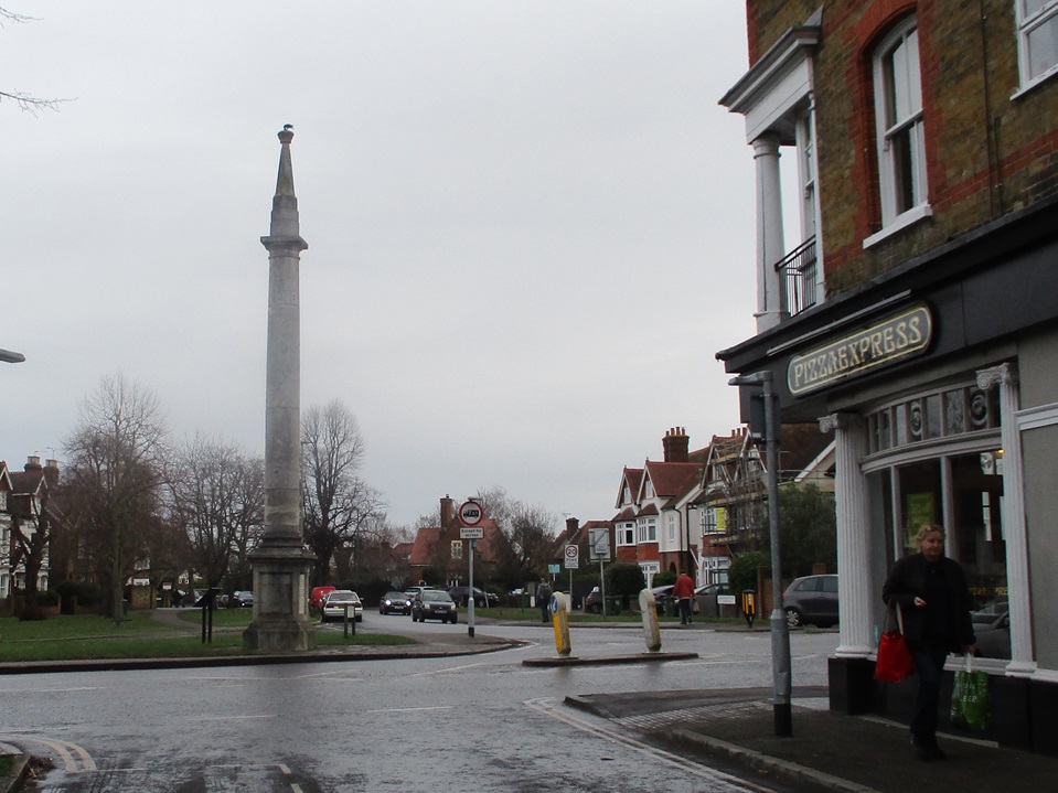
Anyway, we worked out some coordinates for the Church Micro cache, a little way away, and decided to return to them later.    We walked out of the busy town centre and through quiet residential streets, collecting some caches as we went.    Looping back towards the town, we reached Monument Green.  The monument commemorates the Duchess of York, whose grave we’d seen earlier.   It was originally topped by a sundial which came from Seven Dials, in central London.    This proved a bit top heavy, so it was removed and is now on display by the library; we saw it later, and it was waaay too heavy for that slender column.    The adjacent cache was a milestone cache for us – 4500 finds !!! – and it’s a good location, an interesting place we wouldn’t have visited otherwise.

Fancy entrance to Portmore Park

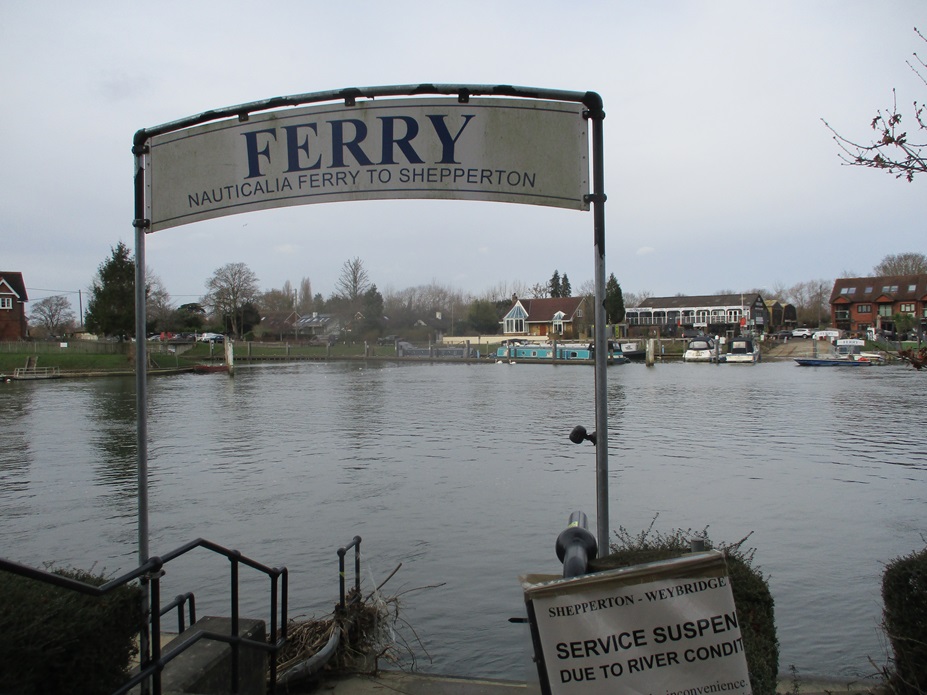
From the green, we headed north, passing some impressive pillars which used to lead to Portmore Park (it’s now a housing estate).  We soon reached the river, at the confluence of the rivers Wey and Thames.  Both rivers were high, just within their banks, and flowing fast.  Just downstream was the Shepperton Ferry.  This place brings back memories – back from 2015 when we walked the Thames Path (it’s the only ferry crossing on the whole, nearly 200-mile path). Actually, our main memory was of hanging around on the far side of the Thames for about 25 minutes, waiting while the ferryman finished his lunch (or whatever he was doing!).  As the river was much, much higher and faster today, the ferry wasn’t running, but still a great spot and much reminiscing.

Passing D’Oyly Carte Island, we turned away from the river and followed wooded paths and fields back into the town.   Once there, we realised we’d missed out one of the caches on our list (doh!), so back we went, to look for ‘Orinoco’s Favourite space’.  We were expecting something to do with litter and Wombles, but, no, it was much-loved by the cache owner’s dog.   While searching, we were hailed by a dog-walking muggle (non-cacher), wanting to know if we were doing ‘a survey’. Sort of, we said, and Mr Hg137 explained geocaching to him while Mrs Hg137 found the cache container.

D’Oyly Carte Island

Also, once here, we realised we were very close to the location of Oatlands Palace, now a housing estate, once home to Princess Frederica.   We asked directions from a passing local and soon found ourselves at the surviving walls and archways of the palace.   Very interesting, we wouldn’t have come here but for the local historian we’d met in the churchyard earlier.

Back to the church, to find the Church Micro we’d calculated the coordinates for at the very start of the day.  Those coordinates (oh dear): we made not one, but two, howling errors, while working out the numbers, and spent some while searching an entirely wrong place, not once, but twice. We eventually started again, read the description properly and came up with some correct numbers which finally, finally led us to the cache.   (One of us has a degree in ‘hard sums’: we should have done better!)

Close to the church is a park and allotments (unusual to have such a big open space so close to a town centre).  while walking across the park towards a geocache, Mr Hg137 suddenly slowed, saying … ‘watch that man’ … he was just ahead of us, heading for a spot oh-so-close to where we were going, too. He bent down and picked something up; we walked up to him. Aha! a cacher caught red-handed! Good to meet you, Flyingfox76 ! Also good to meet you, mummycherub, who appeared very soon to ask to be added to the log. We swapped tales of caching, then went on our separate caching ways.

mummycherub and Flyingfox76

Our caching was nearly done now: we followed peaceful suburban streets to the south of the town centre, finding our last few caches, and returning to the geocar.   We enjoyed Weybridge: it had far more to see than we were expecting, lots of history, attractive corners, rivers, parks, and glimpses of the past.   A good place for a winter walk!

Here are a few of the lots of geocaches we found:

June 6 : Isles of Scilly : St Mary’s part 4 : the way home … stranded …

Hello, Mrs Hg137 here.

Visibility - Not Great
Visibility – Not Great

We were due to leave the Isles of Scilly on June 5th, but our travel plans imploded.  We were due to fly back to Exeter from St Mary’s, but dense fog had descended overnight and there were no planes, none at all.

If the top of the Telegraph Tower isn’t visible, the planes don’t fly … and we couldn’t even see across the runway!  

We sat around for the morning, as more and more hopeful/desperate passengers appeared through the mist and joined those in the airport terminal.  After three hours, visibility was still zero and our flight was cancelled.  The ferry was already fully booked.   At this time of year, there are no planes and no ferries on Sundays.   So we were stranded.  Some hundreds of us were stranded.

About now, the Isles of Scilly emergency procedure swung into action.   (We suspect it is regularly used, though no-one would say so.)   Travellers are advised to return to the place they last stayed and hope that there is still space for them.  That was easy for us, our hotel was only a five-minute minibus ride away, and a phone call established that there would be a room available (but they didn’t yet know which).  But some families faced a trip to the quay, a boat ride to an off island, and a night in a borrowed tent.  And yet others would have no bed for the night, as new visitors would have arrived by boat to take their places.  For them, the sports hall opened up as emergency accommodation, and islanders opened up their homes to offer beds for the night.

Meanwhile, other things had been happening.  By now, an extra sailing of the Scillonian ferry had been arranged for Sunday and we were to be repatriated to the mainland by boat.  And then there would be coaches to transport us back to our airport of departure.  Slick, or what?

Feeling slightly happier, we found seats in a minibus and returned to our hotel.  We dumped our luggage in the store and went for a walk around Hugh Town.  It was grey, gloomy, and misty; a big, big change from the sunny week before.  After an hour or so we went back to our hotel, went to the room we now had, and went to sleep – it had been a stressful day.

By Sunday morning, it was a bright clear day, as if the fog had never happened.  Our ferry was due around lunchtime, so we had one final morning on St. Mary’s.   We decided on another walk around the Garrison.  On a caching trip there two days before, there had been a cache we couldn’t find.   Another cacher had logged the cache not long before, and we messaged them for assistance, but sadly got no reply.  We decided to have another look anyway.  It made no difference – we still couldn’t find it (it has since been temporarily archived).

Scillonian arrives!
Scillonian arrives!

Then it was down to the quay with out luggage to wait for a boat.  A queue of stranded folk turned up, and we were all happy when the Scillonian arrived just after midday.  We were soon on board and the ferry left an hour or so later.   The ferry ride can be notoriously rough, but we were lucky and it was calm, with seagulls and dolphins following the boat.

A row of coaches was waiting for us at Penzance, and we were transported on to Exeter.   Our car park overstay was waived: we were asked if we had travelled from Scilly and the barrier magically lifted.  We arrived home, so tired, a mere 30 hours late – what a journey!

June 4 : Isles of Scilly : St Mary’s part 3 : the Garrison and Peninnis Head

Hello, Mrs Hg137 here.

Porthcressa Beach and the Scillonian

On the last full day of the two extra days we had booked, we decided to explore some parts of St Mary’s that our guided walks hadn’t visited, and do a bit of caching along the way.

We decided to start with a circuit of the Garrison, the westernmost part of St Mary’s.  After a short steep walk up Garrison Hill and through the fortified gate, we set off round the coast path strewn with fortifications. Part way along, there was a cache hidden behind a seat, with a grand view out west over the islands of Samson and St Agnes.  Or there should have been: we looked high and low all around the seat, but there was no sign of a cache.   Oh well…

We gradually climbed a track to the top of the hill, went off a little way to find a cache overlooking tennis courts, then came to a football field.  It is the home of the smallest football league in the world, the Isles of Scilly Football League  which only has two teams, Woolpack Wanderers and Garrison Gunners.  Mr Hg137 couldn’t resist the chance to supply some football coaching to a teenager who was learning how to curve a ball.   Little did he know that others have been there before him (back in 2008 Adidas ran ad campaign, “Dream Big”, when the youth side were coached by some very famous players, among them David Beckham, Steven Gerrard and Patrick Vieira.  There’s a series of one, two, three, and four videos. David Beckham teaches how to curve the ball in the third video; had I known I would have shot some video of Mr Hg137 treading the same turf, kicking the same shots!

Smallest football league in the world
Bend it like ...
Bend it like …

Caches attempted, we walked back down the hill, passed the Star Castle Hotel, along Porthcressa Beach and then out onto Peninnis Head.  We passed the island allotments and were soon out on the coast path overlooking the rocky shore. The allotments have the best view of any I have seen, though the high hedges round each plot suggest they’re battered by the wind; we passed an allotment holder, carrying a huge lettuce and a bag of new potatoes, and he said there had been no frost that winter so the potatoes were planted in February (gulp, it was late April when our potatoes were planted).

Peninnis lighthouse
Peninnis lighthouse
Pulpit Rock
Pulpit Rock

We stopped for lunch, backs to a large rock, looking out to sea past the lighthouse at the end of the point, and then applied ourselves to our next cache, Pulpit Rock, hidden close to one of the named rock formations of jointed granite at the edge of the sea.   The search took a while, there are many crevices and hollows, all on a very steep slope right above the ocean.   The cache was originally placed in August 2001, and it is England’s 12th oldest active cache (and we have found six of them!).   Imagine our puzzlement when we found another cache container hidden under a nearby rock close by. We signed both logs, to be certain, but we are not sure if this other container is a cache … or not?

A little way inland, we came to a millstone.  It seemed an odd place to find one, but there used to be a windmill here … and now there’s a cache.   We sat on the nearby seat to sign the log and watched a tame sparrow and blackbird hoping for a crumb or two from us. Then a gentleman appeared at the millstone and sat down on it. Was he a cacher? No, a locum dentist enjoying his lunchbreak!

Returning to the coast path, we walked round into Old Town, to revisit the church and find the associated Church Micro cache.  We had visited the church earlier in the week and been told about the monuments, the two British politicians buried in the churchyard and much more.  As a result we were a little cocky about using the waypoints, got ourselves in a tangle, and went round the graveyard several times.  Next, we found we had already passed the cache and needed to retracing our steps to find it.  Mr Hg137 delved into the undergrowth and failed to see a low branch. Crunch !

We walked back into Hugh Town and back to the strand, overlooking the harbour.  It was only mid-afternoon, and we decided we had time for one more cache, another Church Micro, starting at Our Lady Star of the Sea Catholic Church, on the strand overlooking the harbour. Earlier in our holiday, we had ambled by this church several times; if only we had researched and calculated the numbers then…  As it was, our walking around Peninnis was not over. The cache took us back where we had been much, much earlier in the day. The day was hot, and our legs were weary..and the water at Porthcressa Beach was so inviting….but we are cachers.  A long trek later, we reached our target and the cache log was signed.

Finally, there was time for a Troytown Farm icecream and a paddle before packing to leave.  Mr Hg137 was all set for a swim – he changed his mind after he saw the jellyfish!

And was that the end of our caching on the islands?   Read the postscript in the next post to find out.

Here are some of the caches we found:

June 2 : Trackable : Czech Republic Flag Tag

Hello, Mrs Hg137 here.

It’s been nine months since we found a trackable!   And we didn’t exactly ‘find’ this one.   Another group of cachers, Beach44Rock, had already found the cache containing the trackable.  They weren’t sure what to do with the trackable so we said we would take it.

Czech Republic Flag Tag

Anyway, here is the (short) life history of the trackable, which has been much interrupted by pandemic lockdowns.    It started off near Braintree in Essex in June 2020, made a short hop to near Stansted in October 2020, then moved to St Mary’s, Isles of Scilly on New Year’s Day 2021, where the cacher who placed it said they were distracted by humpback whales!     

Winter on the Isles of Scilly

Six months passed, and it made an unrecorded journey – likely by boat – from St Mary’s to St Agnes and we picked up there in early June from a cache there.  

And what of the mission for this trackable?   It is:

…”Hello there. I’d like to go to the Czech Republic and travel all around it and then around europe on the way home. Please take plenty of photos of me. Many Thanks” …

So far that hasn’t happened but we’ll move it eastwards and see if we can get it closer to the Czech Republic.

June 2 : Isles of Scilly : (St) Agnes and Gugh

Hello, Mrs Hg137 here.

It was a grey, misty morning as we climbed aboard the boat which would take us to St Agnes, the smallest and quietest of the inhabited islands of the Isles of Scilly.   To the islanders, it is simply “Agnes”, from the Cornish Agenys, and the prefix was added at some point to bring it in line the islands of St Mary’s and St Martin’s. And it’s not one island, but two, as it’s joined to another island, Gugh, by a sandbar which is exposed at low tide.  

The waves were just breaking over the sandbar when we left the quay; not to worry, we would be able to cross it later when the tide was lower.  Our group of fifteen set off clockwise around the island, crossing the bumpy cricket pitch outfield and arriving at the tiny church.  Many victims of shipwrecks are buried close to here (some of those bumps!), and the graveyard includes a victim of the Schiller shipwreck , Germany’s equivalent to the Titanic.   Although there’s a Church Micro here, we decided to take caching opportunities as they arose, so as not to hold up our group.

A little further on, we came to Troytown Farm, the most southwesterly settlement in England.  It’s also known for its icecream, sold all round the islands (of course we tried it, and it’s lovely).  The name comes from the turf and stone labyrinth which is just beyond the farm.   Records mentioning it go back to the 1720s but it may be much older.

It was still misty and quiet, and the island had an entirely different character.  The blue skies and turquoise seas were invisible, and the mist and granite rock formations gave a feeling of Dartmoor.  We worked our way round the coast, stopped for lunch at the Coastguard Café , then returned to the Coast Path, crossing Wingletang Down to reach the southernmost point of the island.   By now, Mr Hg137 had got the GPS out and here is what happened, from our cache log:

… “The GPS was pointing to a large stack of rocks. And a family were there… looking… ‘are they cachers?’  Our walking group ‘marched on’…
Then from some distance away we heard the triumphant ‘Found it !’ Yes, they were cachers. Now the race was on, could we get to the cache before our group climbed the second stile.
Yes !   Sorry our chat was brief Beach44Rock – happy caching!  “…

As we rounded the tip of the island, the weather magic happened, too.   The mist gradually lifted, the sea and the horizon appeared, and the sun gradually broke through.   Passing through the main settlement, Middle Town, with its disused lighthouse, listed phonebox (we simply forgot to look for the cache hidden here!), and post office/shop, we had almost finished our circuit of the island.

Middle Town
Middle Town

The only shop ...
The only shop …

Now the tide was lower, we could see the sandbar (tombolo is the proper word)   and we walked down to the beach and across the bar to Gugh.    Our party forged ahead across the sand as we swiftly gathered the information we needed for ‘The most popular bar in Scilly’ earthcache, then we caught them up on the far side. 


We explored Gugh, too, with its heather, moor, standing stones and nesting birds (there are no rats on either island, and the ground-nesting birds thrive).    

The most south-westerly pub in the UK

Back across the tombolo to Agnes, it was a short walk to another bar, at the most south-westerly pub in the UK, the Turk’s Head   I stopped for a pint, and Mr Hg137 had a cooling J2O.   It had a good view down to the quay, so had a good view of the approaching boat, coming to take us back to St Mary’s, and another good view of the Scillonian, heading back to Penzance.

May 31 : Isles of Scilly : St Mary’s part 2 : Around the Island

Our walking holiday was going well, but our geocaching wasn’t.

We were walking in a group of 15 with a leader stopping at places on route, to point out various items of interest. This makes geocaching difficult, as it is tricky to wander yards away from a path, search for a minute or so, open a cache, sign the log, and re-hide without losing the rest of the group. We had walked around two of the Islands (Bryher and St Martins) without the opportunity to find a cache.

Taylor’s Island – a tidal island just off St Mary’s

Today though, we were circumnavigating (-ish) St Mary’s – the largest of the Scillies. Our route of about 9 miles would visit many of the Island’s places of interest.

There are many beaches to explore, there is an airport runway to cross, Roman ruins to find, and several Iron Age burial chambers to look at. Our walking leader is an expert in such burial chambers, and we had seen a few on our previous walks. So, when she stopped at Innisidgens Burial Chamber we had an opportunity to locate a geocache called ‘Innisidgens View’. The cache location was a few yards on from the chamber, but with a hint of ‘where a seat used to be’, we surmised the location would be close to the footpath.

One of the many Iron Age Burial Chambers on Scilly

Indeed it was, and although the cache was hidden in an unexpected way, we were able to open the cache (a film canister) and attempt to sign the cache before our group walked by. The word ‘attempt’ is key here, as the log was very, very sodden, so we photographed it, and re-hid it. It was a shame that this cache was at the poorer-quality end of caches as a few of our walking group were ‘vaguely interested’, and showing a sodden piece of paper and film canister hardly piqued their interest. Still a cache is a cache – irrespective of container.

Our route took us around the Northern tip of the Island passing several other caches. We thought we had time to attempt another during lunch, but when we combined the distance we would have to walk, and that the cache was a ‘tree-climb’ , we left it.

Memorial stone to
Sir Cloudesley Shovell

As we walked we were told about shipwrecks, and in particular the loss of HMS Association and its fleet of accompanying ships. 2000 sailors lost their lives in November 1707 – one of the worst maritime disasters in the UK. The Admiral of the Fleet, Sir Cloudesley Shovell, and his step-sons all perished in the wreck. A monument to him has been placed to close to where his body was found, he is buried at Westminster Abbey.

From shipwrecks to aircraft, and our route took us by the end of St Mary’s Runway – making sure we could cross the runway by observing a green light on ‘the only traffic lights on the island’.

Old Town, St Mary’s

Heading back to Hugh Town, a much older, small settlement exists called Old Town, The group paused for a refreshment break, and we had another opportunity to go caching. A few yards away, in a raised flower bed, was another cache. It took us some time to locate it, as the hint ‘under a rock’, seemed to apply to every object in the flower bed, except the plants!

Harold Wilson lived here !

Old Town also boasts a Church (a 5 stage Church Micro) and the grave of former Prime Minister Harold Wilson. He loved Scilly and came often and stayed in a cottage near to the Church. The cottage is opposite our final cache of the day ‘Harold Wilson lived near here’. This was an easy spot as the vegetation covering the cache had recently been chopped back, and the cache was very visible. About half the group had extended the day’s walk from Hugh Town around Peninnis Head, we ambled back to the hotel separately enabling us to find the cache with little fuss.

A great 9 mile walk around St Mary’s, but only 3 caches found on route!

September 12 – Seattle Ferry Travel tag

Hello, Mrs Hg137 here again.

Seattle Ferry Travel Tag

Seattle Ferry Travel Tag

In two of the three caches on Cramond island in the Firth of Forth, we found trackables. Both started off in the USA and I surmise that they were dropped off by the same geocacher (they were – I’ve checked).

The second trackable was ‘Seattle Ferry Travel Tag’. This trackable set off from Oregon in 2012 and wants to travel around by ferry. Once again, we haven’t been able to oblige so far – there aren’t many ferries at all near where we live – but at least the trackable has had a memorable time in Scotland.

September 12 – Celeste

Hello, Mrs Hg137 here.

Celeste

Celeste

In two of the three caches on Cramond island in the Firth of Forth, we found trackables. Both started off in the USA and I surmise that they were dropped off by the same geocacher.

The first trackable was ‘Celeste’. Her mission is to visit Hawaii, South America, China and India. Hmm, she’s a little way off course! And here’s the story of how Celeste came to be a trackable on a small island in Scotland:

… “This hitchhiker was found in a cache in Reno, Nevada by our 8 year old daughter, Rachael. The second she laid her hands on it, she said she wanted it to become a Travel Bug.

On the way home, Rachael decided that the dolls name should be Celeste but couldn’t decide where she wanted Celeste to travel to. We talked about ideas for a while but when she got home, she immediately went to her spinning globe in her room. After spinning it, she stopped it randomly with her finger and what she was pointing to was a destination.

There was no waiting to get this done. No sooner had I stepped out of our truck when Rachael asked when the travel tag would go on her. I went straight to the drill press to install a hole. We had several traveling tags to choose from and Rachael thought it would be a good idea to use the Nevada State Flag so that everyone would know where Celeste was from. “ …

I’m not sure we can manage anywhere as exotic as Hawaii, but we’ll try to find somewhere suitable for Celeste’s next adventure.

September 12 – Edinburgh Day 4 (Cramond Island)

Something a bit different to finish our expedition in the Edinburgh Area.

Cramond Island

Cramond Island

Situated a few miles North West of Edinburgh, Cramond Island is accessible twice a day for two hours either side of each low tide. We had researched the tide times before we left home, and low tide was late morning so provided we had left the island by 1pm ish we should be alright.

The island is about a mile offshore reached by a raised concrete causeway. Even at low tide this can be slippery! Concrete pylons run parallel to the causeway path – these were used as a submarine defence boom during WWII.

The Causeway

The Causeway

We were expecting a very ‘natural’ island but scattered about it are the remnants of WWII fortifications built to prevent enemy warships attacking the Firth of Forth.

Island Fortifications

Island Fortifications

When we crossed, we passed two ladies who had clearly camped overnight (i.e at HIGH tide), and for a while we thought we had the 19 acre island to ourselves. But as our visit went on, we were aware of more and more people on the island or indeed crossing the causeway to visit.

Looking back at the mainland.. cracking campsite!

Looking back at the mainland.. cracking campsite!

We would have loved to have seen great views across the Firth, but like our previous day, low mist prevented us from getting a good view. Still the low mist, and a nearby ship’s foghorn, added to the eerie atmosphere that a deserted island brings.

Why were we there ? Because there were 3 standard geocaches, and an Earth cache to find. The Earth Cache was based on the causeway, and focussed not on geology but how tides work.

Two of the three standard caches were hidden in the concrete rubble of the WWII buildings – the other under a rock in relatively plain view of muggles as they stepped onto the island.

What a great log book!

What a great log book!

We walked back from the island in good time, content in finding all 4 caches and 2 trackables! Our next destination would be much, much noisier… Blackpool – to see the Blackpool Illuminations!