February 10 : Swyncombe and the snowdrops

Hello, Mrs Hg137 here.

St Botolph’s Church, Swyncombe

Today’s walk and geocaching adventure took us on a circular route, taking in parts of the Ridgeway and the Chiltern Way and, of course, the snowdrops at St Botolph’s Church. We’d passed the church while walking the Ridgeway back in the summer and had planned to return for the Snowdrop Festival.

There are lots of published snowdrop walks, but we decided to invent our own (similar) version to include some geocaches on our way.   Parking in a large layby on a country road, we set off south across Ewelme Downs.      We were caught up and passed by two lady muggles (non-geocachers) and their excitable spaniel, Banjo, so paused to give them an explanation of geocaching; otherwise, they might have wondered what on earth we were up to, poking around in bushes and behind trees!

We turned east, and climbed gently towards the edge of the Swyncombe Estate, and onto the bridleway known as Ladies Walk.   There were a surprising number of walkers about, and we had snowdrop themed chats with several of them.

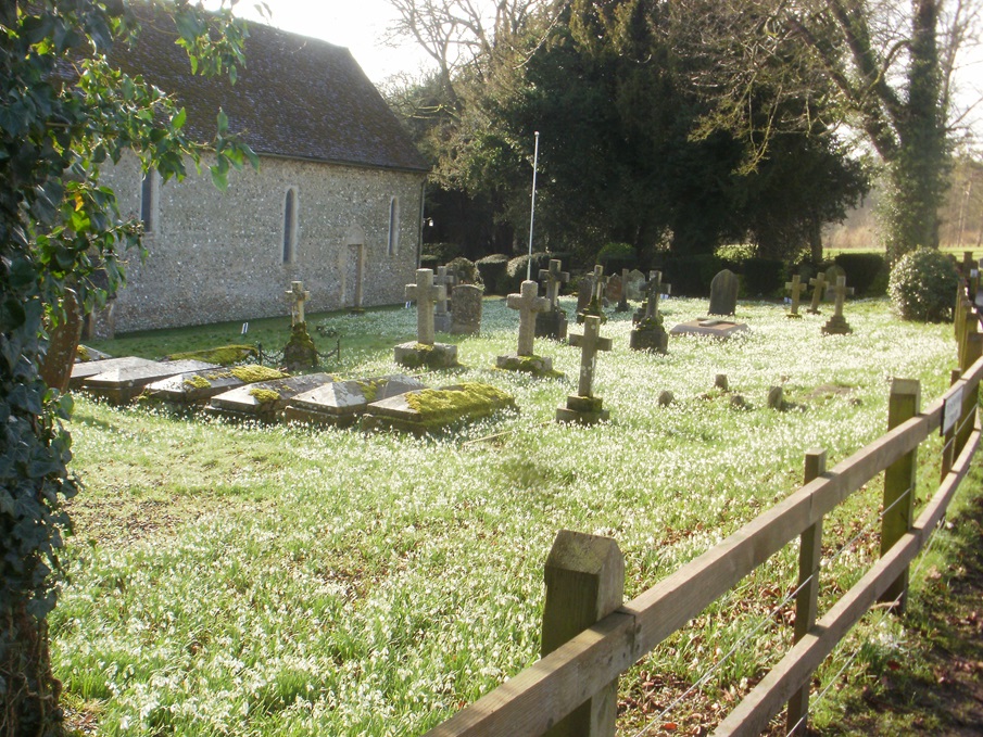
Joining the Ridgeway, we reached Swyncombe Church.   Crikey, it was busy, we were glad we hadn’t tried to park here, there was no space on the narrow lane.    And the people … so many!  

But it was obvious why everyone was here.   The churchyard was carpeted by snowdrops and aconites.   We did several circuits of the churchyard, admiring both the tens of thousands of flowers, and the ginormous pieces of delicious cake on sale by the church.   It was lunchtime and we were tempted, very tempted … but we’d brought a picnic lunch with us, and removed ourselves to a quieter corner of the churchyard for a peaceful break.

After a few more circuits of the churchyard and many more pictures of the snowdrops, we moved off for the return leg of out walk.   Our morning’s caching had been part of the Ridgeway Ramble series of caches, while the afternoon was planned to be a number of puzzle caches that we’d solved over the previous few days.   Puzzle caches tend to be found less often than standard caches, and that also means they are harder to find (less logs to go on, no tell-tale ‘cacher’s path’ to the location).   We found five, distributed along a steep down-and-up section of the Ridgeway and the Chiltern Way

The Ridgeway

We stopped to chat to two walkers: yes, they’d seen the snowdrops (of course!) and they were also checking a route for a Ramblers walk in the next few days, which will, unsurprisingly, pass the snowdrops.    Our route now followed the wooded northern edge of Swyncombe Downs, along the line of a medieval earthwork, with expansive views across Oxfordshire to the north.    The woods gave way to a grassy hilltop, then we plunged down a steep descent through more woodland – skidding to a stop a couple of times to plunge into the undergrowth for a late cache or two – then we emerged back into full daylight at the start point of the walk.

A very old postbox

We’d saved one special cache for last: one from the ‘Victoria’s Post Box’ series, which celebrate the diminishing number of working postboxes from Queen Victoria’s reign.   We’d done copious online research and had come up with some coordinates, not too far from the box itself.   Parking close-ish to the final location, we went for a walk, and then spent a while crashing about in the undergrowth to no avail.  We read some old logs and came up with another location (well, exactly where we’d first looked). This time a more dedicated search and feel (and a torch) located the container. After the 30 minutes of angst locating the cache, this was our favourite for the day … apart from those fantastic snowdrops!

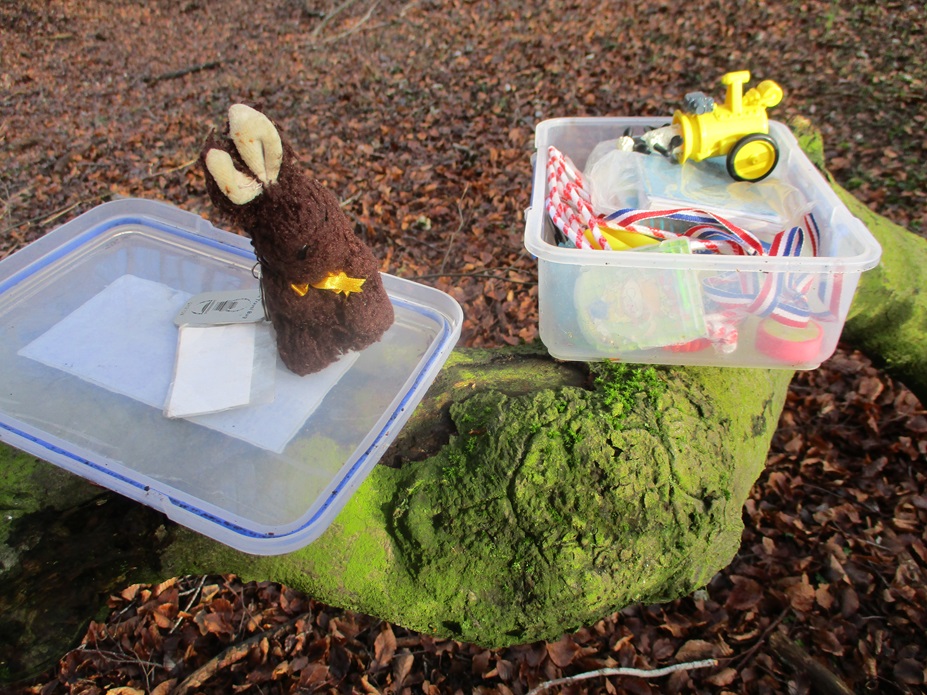
Here are some of the caches we found:

July 28 : The Ridgeway : Nuffield to Kingston Blount

St Botolph’s, Swyncombe

Unlike our previous sections of the Ridgeway, today’s Ridgeway walk would be quite long at approximately 10 miles. We would have liked to have made it shorter, but our research into parking places failed to one before the 10 mile mark, and even then it was a smallish, puddly area just about big enough to turn one car in, and park another.

The weather was a little windy, but dry, unlike the preceding days of apparent non-stop showers.

We had about 10 caches to find, mainly in the first 5 miles or so, and very few caches in the latter half of our walk.

We left Nuffield behind, crossing a couple of fields, and then a golf course. The Huntercombe golf course is not too far away from the National Trust property Nuffield Place, This is where the car designer and philanthropist William Morris (Viscount Nuffield) lived – he enjoyed a round of golf and for many years owned the Huntercombe course.

Huntercombe Golf Club

There was clearly a golf day about to start as many people were congregating in the car park, chatting away. We strode across a couple of fairways taking great care, lest an errant golf ball was being struck in our direction.

Then the fun started, one of several steep climbs (and of course several descents too). Sometimes we climbed through farmland (yielding great views), other times, we climbed through dense woodland, where the views were non-existent, but there were caches to find.

Four of the caches were from a series called the Ridgeway Ramble series. We crossed ‘through’ the series and found numbers 12, 11, 1 and 2. All relatively straightforward hidden behind flint stones or bark.

Being a Friday, there were few people about – we passed an elderly couple out for a 4 mile walk, a group of 3 (possibly American) who were walking about 20 miles but weren’t really sure where they started… or indeed where they would finish. 20 miles seemed a long distance, but one other man we met was going further. He was walking about 40 miles from Tring station to Goring. He had started walking at 3 AM !

Soon we arrived at Ewelme Park Farm. A collection of farmyard buildings surrounding a mock-Elizabethan grand house. We could peer through a couple of the gates and and admire the distant view, but could only marvel at what we later discovered online (8 bedrooms, swimming pool, tennis court, stables etc).

Inside St Botolph’s

We continued into woodland climbing again and arrived at St Botolph’s Church, Swyncombe. The name Botolph’s rang a bell – its a place with a church on the South Downs Way in Sussex. Were these two connected ? Apparently there are over 70 St Botolph’s Churches in England, mainly in the Eastern Side of the country (Lincolnshire to Sussex). St Botolph was the patron saint of travellers and many of the other churches are near ‘gates’ or ‘boundaries’ This St Botolph’s church was clearly meant for travellers on the Ridgeway and built over 1000 years ago. Apparently every February the graveyard is awash with snowdrops – something we must go back and see!

Leaving the church, we descended steeply and then climbed even more steeply on a path adjacent to a field of sheep on one side, and a beautiful flowered hedge on the other. Our puffing and panting uphill, allowed punctuated stops to admire the many butterflies flitting from flower to flower. We saw at least 5 or 6 different species.

Arriving at more woodland was probably the best cache of the day. An ammo can. This ammo can contained about 20 Kinder Egg shells. We’ve met these type of caches before. The paper log, the log you have to sign, is only in one of the shells. You have to open each shell until you find the log. We devised a plan, take from the can, open the shell, if there was no log, place the cache container on a separate pile. Easy to say, but crouched under branches, with nearby brambles, harder to implement. We didn’t need to implement the plan at all! Mr Hg137 took one shell, opened it, and discovered the log! 19 shells we didn’t have to search! Win!

We only a had a couple more caches to find before we dropped down to a flat path. Both were quite reasonable size containers, though not as big as an ammo can. But one had let in so much water the paper log was virtually unsignable.

The flat path we arrived at, felt at first a godsend, after the steepness of the hills we had been climbing, but after a while we grew tired of the hedges either side, and no caches to find. The track took us across a couple a couple of minor roads (with a certain amount of car parking space – how did we miss those in our online research?), until we went underneath the noise M40. This particular bridge is at the base of the Stokenchurch cutting, and traffic is either zooming downhill, or changing gear to for the slog upwards through the chalk cutting.

We still had a mile or two to our parked car, and two genuine caches to find. The first (hint ‘magnetic’) was hidden on a water trough – easy enough … but… a prominent sign stating ‘private land’ put us off searching the trough. Reading several online cachers logs, we discovered the cache was ‘on private land’ (tsk, tsk) – we made a quick sortie, found it, and signed the log very, very quickly. Several finders all say this cache should be removed – but it appears no action has been taken.

The Challenge Cache we didn’t quite qualify for!

Our last cache was by our parked car. It was though a ‘challenge’ cache, and we weren’t quite sure we qualified. We signed the paper log, but couldn’t log the find online until we could verify we could meet the challenge.

The challenge read :

This challenge is to find 21 Church Micro caches with at least 7 denominations, spread across 7 counties. These can be either ceremonial or ‘project-gc’ ones. In each county, you must find 3 caches of different church denomination.

We discovered we had six counties, but not a seventh!

As we drove away we remembered the 10 or so caches we had found that day, and the many hills we had climbed too!